1900s (20th Century) Maps of Lost Creek, Kentucky
Explore 7 historic maps of Lost Creek from the 1900s (20th Century). These maps offer a rare glimpse into what life looked like during the 1900s — showing old roads, neighborhoods, homes, and landmarks that have changed or disappeared over time.
Whether you're researching your family's past, planning a metal detecting trip, or studying how Lost Creek's landscape evolved across the 1900s, these high-resolution maps are a powerful tool for exploring the history of this region.
- Focus on a specific era: All maps on this page are from the 1900s, giving you a focused view of this time period.
- See what’s changed: Compare century-old streets, trails, and buildings to today's modern landscape using overlays and satellite layers.
- Research with precision: Use these maps for genealogy, historical research, land use analysis, or educational projects.
- View, download, or print: Maps are fully viewable online in high resolution, and can be downloaded or printed for your own records.
Start exploring Lost Creek's history through authentic maps from the 1900s. This is your window into the past.
Lost Creek, KY maps
(7)- 1913 Map of Buckhorn
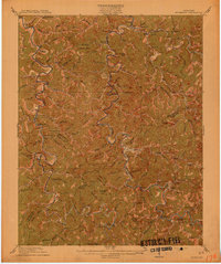 1913 Buckhorn1913 Print · USGSThe North and Middle Forks of the Kentucky River dominate this pre-WWI landscape of steep ridges and deep valleys. Genealogists can locate family homesteads near Witherspoon College or trace ancestors along the Lexington and Eastern Ry through Chavies and Haddix.2 unique versions available
 - 1954 Map of Haddix, 1955 Print
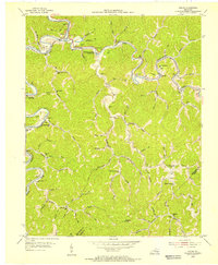 1954 Haddix1955 Print · USGSBreathitt County in the mid-fifties is seen here through its intricate network of river-bottom settlements and remote ridge schools. Researchers can trace family ties through numerous mountain burial grounds and landmarks like Haddix Cem, Whick Sch, and New Bethlehem Ch.
 - 1957 Map of Jenkins, 1974 Print
 1957 Jenkins1974 Print · USGSThe Cumberland Plateau in the mid-twentieth century reveals a complex landscape of winding river valleys and deep-seated industry. Genealogists and historians can trace the development of Hazard, Jenkins, and Pikeville alongside extensive Numerous Oil and Gas Fields and the routes of the Chesapeake & Ohio Railway.
 - 1960 Map of Jenkins
 1960 Jenkins1960 Print · USGSEastern Kentucky and the West Virginia borderlands are captured at a mid-century peak of the coal and rail era. Trace the industrial corridors of the Chesapeake and Ohio RR through mountain hubs like Hazard and Jenkins.
 - 1961 Map of Haddix, 1962 Print
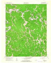 1961 Haddix1962 Print · USGSBreathitt County in the early sixties was a landscape of coal mines and riverside rail depots connected by the winding Troublesome Creek. Genealogists and historians can trace family ties through Haddix Cem, locate the Riverside Christian Training Sch, and find old post offices like Copland (Saldee PO).
 - 1972 Map of Haddix, 1973 Print
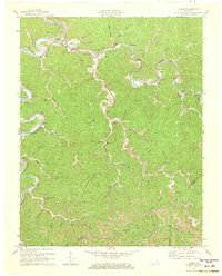 1972 Haddix1973 Print · USGSBreathitt County's intricate river valleys and rail corridors are captured here in the early 1970s. Genealogists and local historians can locate family landmarks such as Haddix Cem, Strong Cem, and the Riverside Christian Training Sch.
 - 1977 Map of Hazard, 1983 Print
 1977 Hazard1983 Print · USGSEastern Kentucky's coal country comes into sharp focus during the late seventies, showing the deep-set river valleys and mountain gaps that shaped regional life. Genealogists can trace family connections through river-bottom settlements like Oneida, Krypton, and Bulan or follow the Seaboard System rail lines.
End of results
Showing maps 1-7 of 7
Top cities near Lost Creek
Frequently asked questions
- What are the different types of historical maps available for Lost Creek?
- What is the oldest map of Lost Creek?
- Where can I purchase historical maps of Lost Creek for my home or office?
- Where can I download high-res historical maps of Lost Creek?
- Are there historical topographic maps available for Lost Creek?
- Is there historical aerial imagery available for Lost Creek?
- Where are historical maps of Lost Creek sourced from?