1910s Maps of Caldwell County, Kentucky
Explore 3 historic maps of Caldwell County from the 1910s. These maps offer a rare glimpse into what life looked like during the 1910s — showing old roads, neighborhoods, homes, and landmarks that have changed or disappeared over time.
Whether you're researching your family's past, planning a metal detecting trip, or studying how Caldwell County's landscape evolved across the 1910s, these high-resolution maps are a powerful tool for exploring the history of this region.
- Focus on a specific era: All maps on this page are from the 1910s, giving you a focused view of this time period.
- See what’s changed: Compare century-old streets, trails, and buildings to today's modern landscape using overlays and satellite layers.
- Research with precision: Use these maps for genealogy, historical research, land use analysis, or educational projects.
- View, download, or print: Maps are fully viewable online in high resolution, and can be downloaded or printed for your own records.
Start exploring Caldwell County's history through authentic maps from the 1910s. This is your window into the past.
Caldwell County, KY maps
(3)- 1910 Map of Princeton
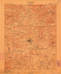 1910 Princeton1910 Print · USGSCaldwell County was a bustling rail hub at the turn of the century, centered on the strategic junction at Princeton. Genealogists can trace rural family roots through a dense network of country schools and churches like Heathen Hill School and Caldwell Chapel.5 unique versions available
 - 1911 Map of Dawson Springs
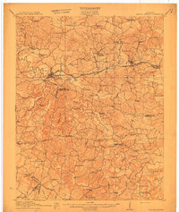 1911 Dawson Springs1911 Print · USGSWestern Kentucky’s coal and rail corridors are captured here just after the turn of the century. Genealogists can trace family footprints through dozens of rural sites like the Daniel Boone School, Franklin's Store, and the Fox Run Mine.2 unique versions available
 - 1916 Map of Fords Ferry
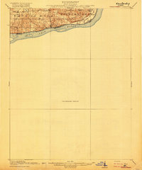 1916 Fords Ferry1916 Print · USGSThe Illinois-Kentucky borderlands along the Ohio River come alive in this survey from the mid-1910s. Genealogists can trace the rural school system through Double Box School and Love School or locate early commerce at Fraileys Store.2 unique versions available
End of results
Showing maps 1-3 of 3
Top cities of Caldwell County
Frequently asked questions
- What are the different types of historical maps available for Caldwell County?
- What is the oldest map of Caldwell County?
- Where can I purchase historical maps of Caldwell County for my home or office?
- Where can I download high-res historical maps of Caldwell County?
- Are there historical topographic maps available for Caldwell County?
- Is there historical aerial imagery available for Caldwell County?
- Where are historical maps of Caldwell County sourced from?