1900s (20th Century) Maps of Calloway County, Kentucky
Explore 39 historic maps of Calloway County from the 1900s (20th Century). These maps offer a rare glimpse into what life looked like during the 1900s — showing old roads, neighborhoods, homes, and landmarks that have changed or disappeared over time.
Whether you're researching your family's past, planning a metal detecting trip, or studying how Calloway County's landscape evolved across the 1900s, these high-resolution maps are a powerful tool for exploring the history of this region.
- Focus on a specific era: All maps on this page are from the 1900s, giving you a focused view of this time period.
- See what’s changed: Compare century-old streets, trails, and buildings to today's modern landscape using overlays and satellite layers.
- Research with precision: Use these maps for genealogy, historical research, land use analysis, or educational projects.
- View, download, or print: Maps are fully viewable online in high resolution, and can be downloaded or printed for your own records.
Start exploring Calloway County's history through authentic maps from the 1900s. This is your window into the past.
Calloway County, KY maps
(39)- 1936 Map of Conyersville
 1936 Conyersville1936 Print · USGSHenry County, Tennessee, and the Kentucky borderlands are shown here in the mid-1930s during a period of infrastructure expansion. Genealogists can trace family names at Bradley Cem, Mandels, and Old Antioch Ch while exploring the rail-industrial landscape of Puryear.
 - 1936 Map of Buchanan
 1936 Buchanan1936 Print · USGSBuchanan and the surrounding Henry County farmlands are captured in the mid-1930s just as the Tennessee Valley Authority began its work. Family historians can locate numerous rural landmarks like Blood River Ch, King Cem, and Delno Sch.
 - 1936 Map of Hazel
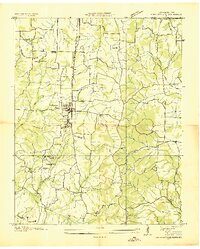
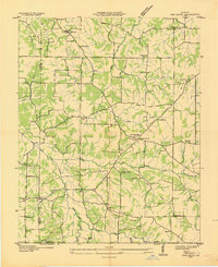
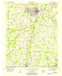
 1936 Hazel1936 Print · USGSCalloway County and the Tennessee borderlands are captured here in the mid-thirties, showing the rail-linked settlements of Murray and Hazel. Genealogists can trace rural family life through dozens of local landmarks like Old Salem Ch, Smotherman Sch, and CCC Camp No 1517.
 - 1936 Map of New Concord
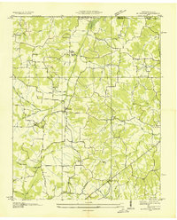
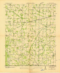
 1936 New Concord1936 Print · USGSCalloway County, Kentucky, is shown here in the mid-1930s as a landscape of small family farms and community hubs. Researchers can locate ancestral sites like Sulphur Springs Ch, Nicks Cem, and schools such as Stone Sch.
 - 1936 Map of Oak Level
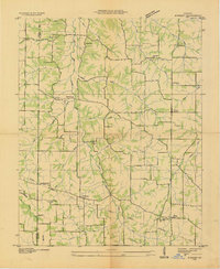
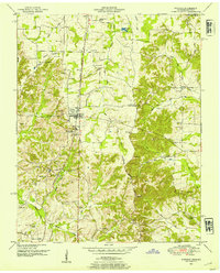
 1936 Oak Level1936 Print · USGSIn the mid-thirties, this corner of Kentucky was a patchwork of family farms and rural schools. Genealogists can trace family names through landmarks like Riley Cem, Hale Spring, and many country schools such as Oak Level Sch.
 - 1936 Map of Lynn Grove
 1936 Lynn Grove1936 Print · USGSSouthern Calloway County in the mid-1930s shows a landscape of small farming communities and country churches before many were consolidated. Researchers can trace family roots through sites like Salem Ch Cem, Paschall Sch, and the crossroads at Lynn Grove.
 - 1936 Map of Hamlin
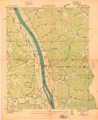
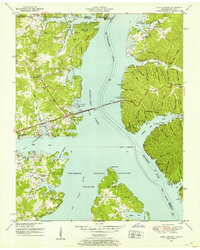
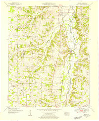
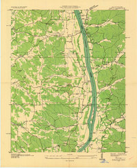 1936 Hamlin1936 Print · USGSThe Tennessee River valley at the Kentucky-Tennessee line appears here in the mid-1930s, prior to the creation of Kentucky Lake. Researchers can trace historic river access points like the Pine Bluff Ferry and ancestral sites such as Elkins Cem or Hickory Grove Ch.
 - 1936 Map of Hardin
 1936 Hardin1936 Print · USGSMarshall County in the mid-1930s shows a landscape of river-crossings and small rural schoolhouses. Genealogists can trace family landmarks like Palmer Cem, the CCC Camp No 508, and the community at Rose Crossroads.
 - 1936 Map of Centerville Landing
 1936 Centerville Landing1936 Print · USGSThe Tennessee and Big Sandy Rivers meet here in the mid-1930s, showing a landscape defined by seasonal landings and rural family settlements. Researchers can trace numerous country schools and churches like Mullins Sch, Hephzibah Ch, and St Mary Ch.2 unique versions available
 - 1936 Map of Benton
 1936 Benton1936 Print · USGSWestern Kentucky's rural Marshall County is captured here in the mid-1930s, showing a landscape defined by river fords and small family settlements. Genealogists can trace hundreds of specific locations, from C C C Camp No 519 to Oak Level and Tatumsville.
 - 1936 Map of Rushing
 1936 Rushing1936 Print · USGSLife along the Tennessee River is documented here just before major dam projects reshaped the border of Kentucky and Tennessee. Genealogists and historians can trace old river access points like Dilday Landing and local landmarks such as Futrell Store or the Hendon Cem.
 - 1936 Map of Dexter
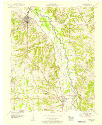
 1936 Dexter1936 Print · USGSCalloway County's agricultural heartland is documented here in the mid-1930s, centered on the Nashville Chattanooga and St Louis Railway. Family historians can trace ancestral roots through numerous local landmarks like Coles Camp Ground Ch, Stewart Cem, and Penny.
 - 1936 Map of Hico
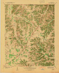
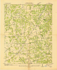 1936 Hico1936 Print · USGSCalloway and Marshall counties are shown here in the mid-thirties during a period of transition under the Tennessee Valley Authority. Researchers can trace deep family roots through numerous cemeteries like Skinner Cem and vanished landmarks such as Vinsons Store or Shady Hill Sch.
 - 1936 Map of Kirksey
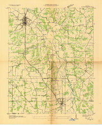
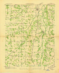
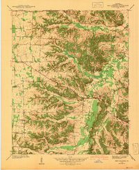
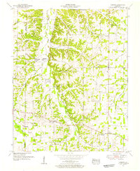
 1936 Kirksey1936 Print · USGSCalloway County is captured here in the mid-1930s as the Tennessee Valley Authority began documenting the river basins. Genealogists can locate family-named landmarks like Wyatt Sch, Mt Hebron Cem, and the crossroads at Coldwater.
 - 1942 Map of New Concord
 1942 New Concord1942 Print · USGSCalloway County is captured here in the early 1940s, showing a landscape of ridge-top farms and winding creek bottoms before major modern development. Genealogists can trace family roots through numerous small burial grounds like Outland Cem and country landmarks such as Sulphur Sprs Ch or Pottertown.
 - 1942 Map of Hico
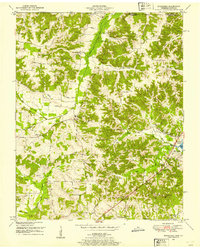
 1942 Hico1942 Print · USGSCalloway and Marshall counties are shown here just before the war, capturing a rural landscape of ridge-top farms and creek-bottom timber. Researchers can locate family landmarks like Tatums Store, Shiloh Ch, and numerous burial sites including Curd Cem.
 - 1950 Map of Rushing Creek, 1953 Print
 1950 Rushing Creek1953 Print · USGSThe Tennessee and Kentucky borderlands appear here just after the filling of the reservoir, capturing a landscape defined by the new shoreline. Researchers can locate family burial grounds like Rushing Creek Cem and landmarks such as the Lookout Tower and Turkey Creek Ch.5 unique versions available
 - 1950 Map of Buchanan, 1953 Print
 1950 Buchanan1953 Print · USGSThe Kentucky-Tennessee line comes alive in the early fifties, showing a rural landscape shaped by the new Kentucky Lake. Genealogists can trace family names at Buchanan Cem, Mt Zion Ch, and the small community of Freeland.2 unique versions available
 - 1950 Map of Paris Landing, 1953 Print
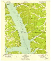
 1950 Paris Landing1953 Print · USGSKentucky Lake and the Tennessee River valley are shown here just as the post-war recreational and conservation landscape began to take shape. Researchers can locate family homesteads near Old Liberty Ch, Bradford Cem, and the Cypress Creek Cabin Area.5 unique versions available
 - 1950 Map of Hamlin, 1954 Print
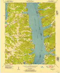 1950 Hamlin1954 Print · USGSThe shorelines of the Tennessee River valley are shown here just after the filling of the reservoir. Researchers can trace the proximity of Fort Henry and Fort Heiman or locate family burial sites like Blood River Cem and Campbell Cem.3 unique versions available
 - 1950 Map of Puryear, 1954 Print
 1950 Puryear1954 Print · USGSHenry County and the Kentucky borderlands are captured here in the early fifties as rural life centered on the railroad. Genealogists can locate numerous family sites like Underwood Cem, Bradley Cem, and the old community at Conyersville.3 unique versions available
 - 1951 Map of Hardin, 1955 Print
 1951 Hardin1955 Print · USGSWestern Kentucky life in the early fifties centered on the river and the rail, long before modern highways bypassed these small communities. Researchers can locate family sites like Starks Cem, the Church Grove Sch, and historic river crossings at Washburn Ford.2 unique versions available
 - 1951 Map of Hazel, 1955 Print
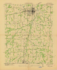
 1951 Hazel1955 Print · USGSCalloway County at the start of the 1950s shows a landscape of growing college towns and quiet rural junctions. Researchers can trace the Nashville Chattanooga and St Louis rail line through Midway and find local landmarks like Old Salem Ch and England Cem.2 unique versions available
 - 1951 Map of Kirksey, 1955 Print
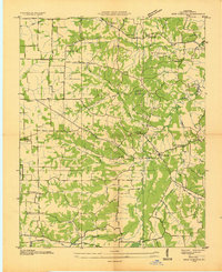
 1951 Kirksey1955 Print · USGSCalloway County and the surrounding river bottoms are documented here in the early fifties, showing a rural Kentucky landscape of crossroads towns and family farms. Researchers can locate early church sites like Mt Hebron Church and vanished features like the Clay Pits near Kirksey.3 unique versions available
 - 1951 Map of Dexter, 1955 Print
 1951 Dexter1955 Print · USGSThe rural corridor between Calloway and Marshall counties is captured here in the early fifties, centered on the Nashville Chattanooga and St Louis rail line. Genealogists can trace family landmarks like Brooks Chapel School, Coles Camp Ground Church, and the Peterson Cem.2 unique versions available
Showing maps 1-25 of 39
Top cities of Calloway County
Frequently asked questions
- What are the different types of historical maps available for Calloway County?
- What is the oldest map of Calloway County?
- Where can I purchase historical maps of Calloway County for my home or office?
- Where can I download high-res historical maps of Calloway County?
- Are there historical topographic maps available for Calloway County?
- Is there historical aerial imagery available for Calloway County?
- Where are historical maps of Calloway County sourced from?