1980s Maps of Campbell County, Kentucky
Explore 11 historic maps of Campbell County from the 1980s. These maps offer a rare glimpse into what life looked like during the 1980s — showing old roads, neighborhoods, homes, and landmarks that have changed or disappeared over time.
Whether you're researching your family's past, planning a metal detecting trip, or studying how Campbell County's landscape evolved across the 1980s, these high-resolution maps are a powerful tool for exploring the history of this region.
- Focus on a specific era: All maps on this page are from the 1980s, giving you a focused view of this time period.
- See what’s changed: Compare century-old streets, trails, and buildings to today's modern landscape using overlays and satellite layers.
- Research with precision: Use these maps for genealogy, historical research, land use analysis, or educational projects.
- View, download, or print: Maps are fully viewable online in high resolution, and can be downloaded or printed for your own records.
Start exploring Campbell County's history through authentic maps from the 1980s. This is your window into the past.
Campbell County, KY maps
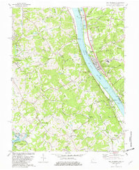
(11)- 1981 Map of Covington
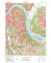
 1981 Covington1981 Print · USGSNorthern Kentucky and Cincinnati meet along the river in the early eighties as suburban communities expand into the hills. Trace the development of Villa Hills and Fort Wright, or locate family sites at Highland Cemetery and Linden Grove Cem.2 unique versions available
 - 1981 Map of Laurel, 1982 Print
 1981 Laurel1982 Print · USGSClermont County's riverfront and rural interior are captured here in the early 1980s, documenting a landscape of small hamlets and family-named landmarks. Genealogists can trace sites like Monroe Cem, Franklin Chapel, and the historic river town of Point Pleasant.2 unique versions available
 - 1981 Map of Alexandria, 1982 Print
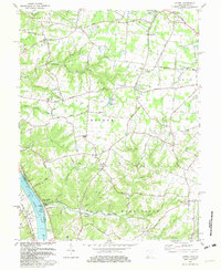
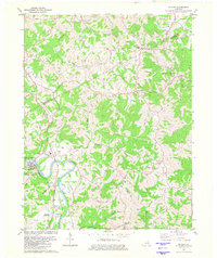
 1981 Alexandria1982 Print · USGSIn the early eighties, this Campbell County corridor shows the winding Licking River and its rural settlements. Genealogists can trace landmarks like St Matthew Ch, Aspen Grove, and the Louisville and Nashville rail line.2 unique versions available
 - 1981 Map of New Richmond, 1982 Print
 1981 New Richmond1982 Print · USGSThe Ohio River valley was a hub of river and rail transport in the early eighties, connecting riverside towns and rural uplands. Genealogists can trace family landmarks at Gubser Mill, Watkins Cem, and the historic Clermont Academy.2 unique versions available
 - 1981 Map of Butler, 1982 Print
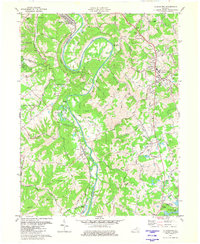
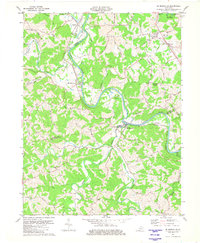
 1981 Butler1982 Print · USGSThe Licking River valley in northern Kentucky was a landscape of small river towns and family farms in the early eighties. Genealogists can trace family roots through sites like Butler Cem, Plum Creek Ch, and the historic Louisville and Nashville rail corridor.
 - 1981 Map of De Mossville, 1982 Print
 1981 De Mossville1982 Print · USGSIn the early eighties, this Northern Kentucky hill country remained a landscape of winding river valleys and ridge-top roads. Genealogists can trace family roots at Caldwell Cem or Smith Cem and locate historic community centers like Morning View and St Marys Ch.
 - 1981 Map of Moscow, 1982 Print
 1981 Moscow1982 Print · USGSThe Ohio River valley near Moscow, Ohio, shows a landscape of heavy river infrastructure and ridge-top farming in the early eighties. Researchers can trace rural lineages through family-named landmarks like Fruit Ridge, McKendree Cem, and the old Flat Rock Ch.2 unique versions available
 - 1983 Map of Withamsville, 1984 Print
 1983 Withamsville1984 Print · USGSClermont and Hamilton counties are shown in the early eighties as suburban growth expands near the river. Researchers can trace family history at Asbury Cem, explore the old Newtown area, or follow the CHESAPEAKE AND OHIO line.4 unique versions available
 - 1983 Map of Newport, 1984 Print
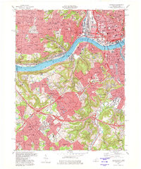
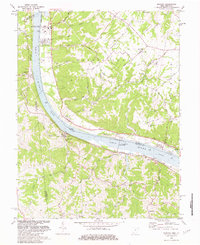
 1983 Newport1984 Print · USGSGreater Cincinnati and Northern Kentucky come alive in this early 1980s survey of the riverfront and its surrounding hilltops. Genealogists and local historians can map out long-standing landmarks like Evergreen Cemetery, CINCINNATI MUNICIPAL AIRPORT (LUNKEN FIELD), and the St Ursula Convent and Academy.2 unique versions available
 - 1986 Map of Cincinnati
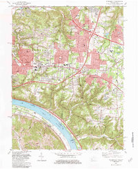
 1986 Cincinnati1986 Print · USGSGreater Cincinnati and its tri-state surrounds are captured here in the mid-eighties as suburban growth reached into the neighboring hills and river valleys. Researchers can trace the development of transit hubs like Greater Cincinnati International Airport and historic sites such as Spring Grove Cemetery.3 unique versions available
 - 1986 Map of Falmouth
 1986 Falmouth1986 Print · USGSNorthern Kentucky and the Ohio River valley are shown here in the mid-1980s, highlighting the region's complex river-and-rail geography. Genealogists and researchers can trace the roads connecting Big Bone Lick, Zion Church, and river towns like Falmouth and Augusta.2 unique versions available
End of results
Showing maps 1-11 of 11
Top cities of Campbell County
- Newport historical maps
- Fort Thomas historical maps
- Alexandria historical maps
- Highland Heights historical maps
- Bellevue historical maps
- Cold Spring historical maps
See more
Frequently asked questions
- What are the different types of historical maps available for Campbell County?
- What is the oldest map of Campbell County?
- Where can I purchase historical maps of Campbell County for my home or office?
- Where can I download high-res historical maps of Campbell County?
- Are there historical topographic maps available for Campbell County?
- Is there historical aerial imagery available for Campbell County?
- Where are historical maps of Campbell County sourced from?