1970s Maps of Carroll County, Kentucky
Explore 2 historic maps of Carroll County from the 1970s. These maps offer a rare glimpse into what life looked like during the 1970s — showing old roads, neighborhoods, homes, and landmarks that have changed or disappeared over time.
Whether you're researching your family's past, planning a metal detecting trip, or studying how Carroll County's landscape evolved across the 1970s, these high-resolution maps are a powerful tool for exploring the history of this region.
- Focus on a specific era: All maps on this page are from the 1970s, giving you a focused view of this time period.
- See what’s changed: Compare century-old streets, trails, and buildings to today's modern landscape using overlays and satellite layers.
- Research with precision: Use these maps for genealogy, historical research, land use analysis, or educational projects.
- View, download, or print: Maps are fully viewable online in high resolution, and can be downloaded or printed for your own records.
Start exploring Carroll County's history through authentic maps from the 1970s. This is your window into the past.
Carroll County, KY maps
(2)- 1971 Map of Madison East, 1973 Print
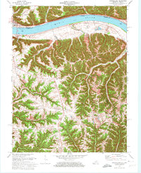 1971 Madison East1973 Print · USGSThe Ohio River corridor at the Indiana-Kentucky border is shown here in the early seventies, featuring the riverfront hub of Madison. Researchers can trace old ridge-top settlements and rural landmarks like St Peters Ch, Monitor, and Mt Carmel Ch.4 unique versions available
 - 1971 Map of Vevay North, 1973 Print
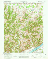 1971 Vevay North1973 Print · USGSThe river town of Vevay and its rural hinterlands are captured in the early 1970s, showcasing a landscape of ridge-top roads and winding creek valleys. Genealogists can trace family landmarks like Fredonia Ch, Popcorn Ridge, and the early layout of Mt Sterling.3 unique versions available
End of results
Showing maps 1-2 of 2
Top cities of Carroll County
- Carrollton historical maps
- Ghent historical maps
- Sanders historical maps
- Worthville historical maps
- Prestonville historical maps
Frequently asked questions
- What are the different types of historical maps available for Carroll County?
- What is the oldest map of Carroll County?
- Where can I purchase historical maps of Carroll County for my home or office?
- Where can I download high-res historical maps of Carroll County?
- Are there historical topographic maps available for Carroll County?
- Is there historical aerial imagery available for Carroll County?
- Where are historical maps of Carroll County sourced from?