1970s Maps of Casey County, Kentucky
Explore 3 historic maps of Casey County from the 1970s. These maps offer a rare glimpse into what life looked like during the 1970s — showing old roads, neighborhoods, homes, and landmarks that have changed or disappeared over time.
Whether you're researching your family's past, planning a metal detecting trip, or studying how Casey County's landscape evolved across the 1970s, these high-resolution maps are a powerful tool for exploring the history of this region.
- Focus on a specific era: All maps on this page are from the 1970s, giving you a focused view of this time period.
- See what’s changed: Compare century-old streets, trails, and buildings to today's modern landscape using overlays and satellite layers.
- Research with precision: Use these maps for genealogy, historical research, land use analysis, or educational projects.
- View, download, or print: Maps are fully viewable online in high resolution, and can be downloaded or printed for your own records.
Start exploring Casey County's history through authentic maps from the 1970s. This is your window into the past.
Casey County, KY maps
(3)- 1970 Map of Dunnville, 1972 Print
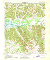 1970 Dunnville1972 Print · USGSAdair and Casey counties appear during the early 1970s as the Green River Lake reservoir reshapes the valley. Researchers can find numerous family burial grounds and country churches like Williams Cem, Shady Grove Ch, and the Mt Calvary Cem Ch.
 - 1970 Map of Mannsville, 1972 Print
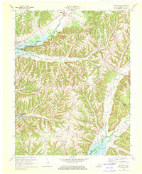 1970 Mannsville1972 Print · USGSTaylor County settlement meets the rising waters of the Green River reservoir in the 1970s. Genealogists can trace family connections at Christie Chapel, Eastridge Cem, and the small community of Feathersburg tucked between the ridges.
 - 1973 Map of Eli, 1974 Print
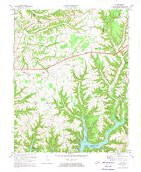 1973 Eli1974 Print · USGSRussell and Pulaski counties are shown here in the early seventies as the region balanced its agrarian roots with modern infrastructure. Genealogists and historians can trace family locations near Irvins Store, Old Friendship Cem, and Locust Grove Ch.
End of results
Showing maps 1-3 of 3
Top cities of Casey County
Frequently asked questions
- What are the different types of historical maps available for Casey County?
- What is the oldest map of Casey County?
- Where can I purchase historical maps of Casey County for my home or office?
- Where can I download high-res historical maps of Casey County?
- Are there historical topographic maps available for Casey County?
- Is there historical aerial imagery available for Casey County?
- Where are historical maps of Casey County sourced from?