1970s Maps of Christian County, Kentucky
Explore 7 historic maps of Christian County from the 1970s. These maps offer a rare glimpse into what life looked like during the 1970s — showing old roads, neighborhoods, homes, and landmarks that have changed or disappeared over time.
Whether you're researching your family's past, planning a metal detecting trip, or studying how Christian County's landscape evolved across the 1970s, these high-resolution maps are a powerful tool for exploring the history of this region.
- Focus on a specific era: All maps on this page are from the 1970s, giving you a focused view of this time period.
- See what’s changed: Compare century-old streets, trails, and buildings to today's modern landscape using overlays and satellite layers.
- Research with precision: Use these maps for genealogy, historical research, land use analysis, or educational projects.
- View, download, or print: Maps are fully viewable online in high resolution, and can be downloaded or printed for your own records.
Start exploring Christian County's history through authentic maps from the 1970s. This is your window into the past.
Christian County, KY maps
(7)- 1972 Map of Haleys Mill, 1973 Print
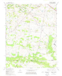
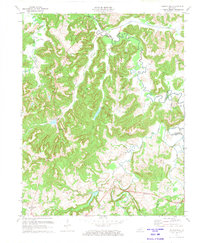 1972 Haleys Mill1973 Print · USGSNorthern Christian County was a landscape of small farming communities and growing oil fields in the early 1970s. Genealogists can locate family landmarks like Atkinson Cem and Johnston Cem or trace early roads near Haleys Mill and Apex.2 unique versions available
 - 1974 Map of Trenton, 1976 Print
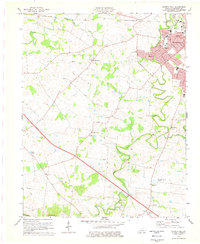
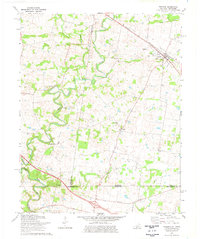 1974 Trenton1976 Print · USGSThe Kentucky-Tennessee borderlands in the mid-1970s reveal a landscape of river-bend farms and rail-dependent towns. Researchers can locate family landmarks such as Woodward Cem, the community of Barkers Mill, and rural sites like Pisgah Ch and Trenton.
 - 1974 Map of Gracey, 1976 Print
 1974 Gracey1976 Print · USGSAcross the rolling borderlands of Trigg and Christian counties in the mid-1970s, this survey documents a network of small rail-side settlements and rural family cemeteries. Genealogists can locate family landmarks such as Ladd Cem and Montgomery Ch alongside the Illinois Central Gulf tracks.
 - 1974 Map of Caledonia, 1977 Print
 1974 Caledonia1977 Print · USGSTrigg and Christian counties in the mid-1970s reveal a landscape of rural hamlets and family farmsteads along the Little River. Genealogists can trace family names at the Old Presbyterian Cem and Bacon Cem, or locate historic sites like Binns Mill.2 unique versions available
 - 1978 Map of Herndon
 1978 Herndon1978 Print · USGSThe Kentucky-Tennessee borderlands south of Hopkinsville are captured here in the late seventies as military activity and rural life converged. Genealogists can locate family names at Major Cem or Garrott Cem and trace the defunct Old Railroad Grade near Howel.2 unique versions available
 - 1978 Map of Church Hill, 1979 Print
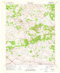
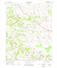
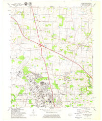
 1978 Church Hill1979 Print · USGSChristian County in the late seventies reveals the suburban growth of Hopkinsville alongside its enduring rural character. Genealogists and local historians can locate specific landmarks like South Union Ch, Merrittstown, and the State Fairgrounds.2 unique versions available
 - 1979 Map of Oak Grove
 1979 Oak Grove1979 Print · USGSThe Kentucky-Tennessee state line divides this 1970s landscape, centered on the strategic presence of Fort Campbell. Researchers can trace the development of Oak Grove and Hensleytown near landmarks like Salem Ch and the Drive-in Theater.2 unique versions available
End of results
Showing maps 1-7 of 7
Top cities of Christian County
- Hopkinsville historical maps
- Oak Grove historical maps
- Crofton historical maps
- Pembroke historical maps
- LaFayette historical maps
Frequently asked questions
- What are the different types of historical maps available for Christian County?
- What is the oldest map of Christian County?
- Where can I purchase historical maps of Christian County for my home or office?
- Where can I download high-res historical maps of Christian County?
- Are there historical topographic maps available for Christian County?
- Is there historical aerial imagery available for Christian County?
- Where are historical maps of Christian County sourced from?