1970s Maps of Cumberland County, Kentucky
Explore 4 historic maps of Cumberland County from the 1970s. These maps offer a rare glimpse into what life looked like during the 1970s — showing old roads, neighborhoods, homes, and landmarks that have changed or disappeared over time.
Whether you're researching your family's past, planning a metal detecting trip, or studying how Cumberland County's landscape evolved across the 1970s, these high-resolution maps are a powerful tool for exploring the history of this region.
- Focus on a specific era: All maps on this page are from the 1970s, giving you a focused view of this time period.
- See what’s changed: Compare century-old streets, trails, and buildings to today's modern landscape using overlays and satellite layers.
- Research with precision: Use these maps for genealogy, historical research, land use analysis, or educational projects.
- View, download, or print: Maps are fully viewable online in high resolution, and can be downloaded or printed for your own records.
Start exploring Cumberland County's history through authentic maps from the 1970s. This is your window into the past.
Cumberland County, KY maps
(4)- 1978 Map of Albany
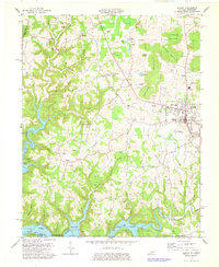 1978 Albany1978 Print · USGSClinton County, Kentucky, is captured in the late 1970s as a landscape of highland ridges and modern reservoirs. Researchers can trace family sites like Bayles Cem, rural centers like Green Grove Ch, and the lakeside infrastructure at Wisdom Dock.2 unique versions available
 - 1978 Map of Wolf Creek Dam
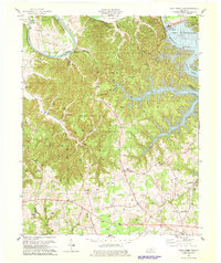 1978 Wolf Creek Dam1978 Print · USGSThe Lake Cumberland shoreline and the Cumberland River valley are captured in the late seventies as the region balanced local industry and recreation. Trace family roots and old landmarks from Winfreys Ferry to the community of Seventy Six and the Seventy Six Falls.3 unique versions available
 - 1978 Map of Frogue, 1979 Print
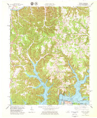 1978 Frogue1979 Print · USGSCumberland and Clinton Counties appear here in the late seventies as the terrain transitions from the Cumberland River to the inlets of Dale Hollow Lake. Researchers can trace rural landmarks from Sexton Park Ch to the many Oil Wells marking the local hillsides.2 unique versions available
 - 1978 Map of Burkesville, 1979 Print
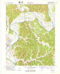 1978 Burkesville1979 Print · USGSCumberland County during the late seventies reveals a landscape of river-bottom farms and active oil extraction. Genealogists can locate family names and burial sites at the Burkesville Cem or trace community roots at Terry Chapel and Bakerton Ch.2 unique versions available
End of results
Showing maps 1-4 of 4
Top cities of Cumberland County
Frequently asked questions
- What are the different types of historical maps available for Cumberland County?
- What is the oldest map of Cumberland County?
- Where can I purchase historical maps of Cumberland County for my home or office?
- Where can I download high-res historical maps of Cumberland County?
- Are there historical topographic maps available for Cumberland County?
- Is there historical aerial imagery available for Cumberland County?
- Where are historical maps of Cumberland County sourced from?