1950s Maps of Cumberland County, Kentucky
Explore 13 historic maps of Cumberland County from the 1950s. These maps offer a rare glimpse into what life looked like during the 1950s — showing old roads, neighborhoods, homes, and landmarks that have changed or disappeared over time.
Whether you're researching your family's past, planning a metal detecting trip, or studying how Cumberland County's landscape evolved across the 1950s, these high-resolution maps are a powerful tool for exploring the history of this region.
- Focus on a specific era: All maps on this page are from the 1950s, giving you a focused view of this time period.
- See what’s changed: Compare century-old streets, trails, and buildings to today's modern landscape using overlays and satellite layers.
- Research with precision: Use these maps for genealogy, historical research, land use analysis, or educational projects.
- View, download, or print: Maps are fully viewable online in high resolution, and can be downloaded or printed for your own records.
Start exploring Cumberland County's history through authentic maps from the 1950s. This is your window into the past.
Cumberland County, KY maps
(13)- 1953 Map of Breeding, 1954 Print
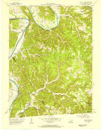
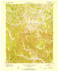 1953 Breeding1954 Print · USGSThe hill country of south-central Kentucky is captured here in the early fifties, showing the rural communities along the Adair and Cumberland county lines. Researchers can trace the locations of old schoolhouses and country churches like Rowetown Sch, Chestnut Grove Ch, and Saltpeter Cave.3 unique versions available
 - 1953 Map of Waterview, 1954 Print
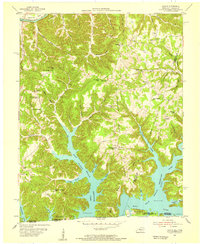
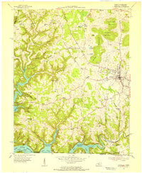
 1953 Waterview1954 Print · USGSCumberland County at the mid-century remains a landscape of river-centered life and small rural school districts. Genealogists can locate Cloyds Landing, the Oliver Ferry crossing, and numerous local landmarks like Baise Chapel and Beech Grove Sch.2 unique versions available
 - 1953 Map of Amandaville, 1954 Print
 1953 Amandaville1954 Print · USGSAdair and Cumberland counties appear here in the early fifties, showing a rural landscape of ridges and creek-bottom settlements. Genealogists can trace family footprints across McGinnis Cem, Inroad, and schools like Walnut Grove Sch or Elliott Sch.4 unique versions available
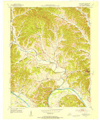
 - 1953 Map of Burkesville, 1955 Print
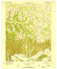
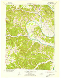
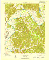 1953 Burkesville1955 Print · USGSThe Cumberland River loops through southern Kentucky in the early fifties, carving out fertile lowlands and providing a lifelines for riverside settlements. Genealogists can trace family names and local landmarks like Parrish Chapel, Dougan Town, and the Seminary Sch.2 unique versions available
 - 1953 Map of Wolf Creek Dam, 1955 Print
 1953 Wolf Creek Dam1955 Print · USGSThe creation of Lake Cumberland in the early fifties fundamentally altered this portion of Clinton and Russell Counties. Researchers can trace submerged shorelines and landforms like Winfreys Rocks or locate vanished landmarks like Seventy Six Falls and Willow Grove Sch.2 unique versions available
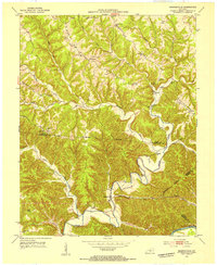
 - 1953 Map of Creelsboro, 1955 Print
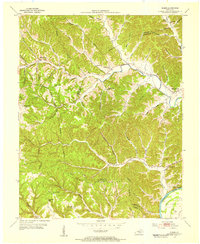
 1953 Creelsboro1955 Print · USGSSouthern Kentucky's river valleys and high ridges are captured here in the early fifties, centering on the winding Cumberland River. Researchers can locate vanished rural landmarks like Old Olga, the Highway Mission, and the Cherry Grove Sch.3 unique versions available
 - 1953 Map of Dubre, 1955 Print
 1953 Dubre1955 Print · USGSThe rural uplands of Cumberland and Metcalfe counties are captured here in the early fifties, showing a landscape defined by creek-side settlements and ridge-top schools. Genealogists can trace family footprints at Mud Camp, Temple Hill Ch, and the many hollows near Marrowbone Creek.2 unique versions available
 - 1954 Map of Frogue, 1955 Print
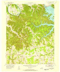
 1954 Frogue1955 Print · USGSCumberland County and the Tennessee borderlands are shown here in the mid-fifties, just as the rising waters of Dale Hollow Reservoir reshaped the valley. Researchers can locate vanished landmarks like Neeleys Fy on the river and rural centers like Spears Chapel and Hegira.2 unique versions available
 - 1954 Map of Blacks Ferry, 1955 Print
 1954 Blacks Ferry1955 Print · USGSThe Kentucky-Tennessee borderlands in the mid-1950s reveal a landscape of deep river bends and ridge-top hamlets. Genealogists can locate family-named sites such as Zeketown and Peytonsburg, or trace historic schools like Bearwallow Sch and Elbow Sch.3 unique versions available
 - 1954 Map of Albany, 1955 Print
 1954 Albany1955 Print · USGSClinton County and the borderlands of the Cumberland Plateau are captured here in the mid-fifties as the local landscape adjusted to the presence of the reservoir. Genealogists can trace family names across dozens of rural landmarks, from Palestine Ch and Evans Sch to the remote crossings at Shipley and Huntersville.2 unique versions available
 - 1954 Map of Vernon, 1955 Print
 1954 Vernon1955 Print · USGSThe Cumberland River loops through Monroe County during the mid-1950s, revealing a landscape of ridge-top schools and river-bottom farms. Researchers can locate family landmarks like Stephens Cem and McMillans Ferry, or trace the rural communities of Vernon and Meshack.2 unique versions available
 - 1956 Map of Corbin, 1966 Print
 1956 Corbin1966 Print · USGSThe Kentucky and Tennessee borderlands are captured here in the mid-fifties, showing the region's shift toward modern interstate travel and reservoir development. Genealogists and historians can trace old community lines near Albany and Monticello or locate early rail junctions along the Southern and Tennessee Central lines.3 unique versions available
 - 1958 Map of Corbin
 1958 Corbin1958 Print · USGSThe Upper Cumberland borderlands appear in the late 1950s as massive reservoirs and early atomic-era growth reshape the region. Trace family roots and vanished landmarks near Lake Cumberland, Oak Ridge, and the Cumberland National Forest.
End of results
Showing maps 1-13 of 13
Top cities of Cumberland County
Frequently asked questions
- What are the different types of historical maps available for Cumberland County?
- What is the oldest map of Cumberland County?
- Where can I purchase historical maps of Cumberland County for my home or office?
- Where can I download high-res historical maps of Cumberland County?
- Are there historical topographic maps available for Cumberland County?
- Is there historical aerial imagery available for Cumberland County?
- Where are historical maps of Cumberland County sourced from?