1900s (20th Century) Maps of Dermont, Kentucky
Explore 9 historic maps of Dermont from the 1900s (20th Century). These maps offer a rare glimpse into what life looked like during the 1900s — showing old roads, neighborhoods, homes, and landmarks that have changed or disappeared over time.
Whether you're researching your family's past, planning a metal detecting trip, or studying how Dermont's landscape evolved across the 1900s, these high-resolution maps are a powerful tool for exploring the history of this region.
- Focus on a specific era: All maps on this page are from the 1900s, giving you a focused view of this time period.
- See what’s changed: Compare century-old streets, trails, and buildings to today's modern landscape using overlays and satellite layers.
- Research with precision: Use these maps for genealogy, historical research, land use analysis, or educational projects.
- View, download, or print: Maps are fully viewable online in high resolution, and can be downloaded or printed for your own records.
Start exploring Dermont's history through authentic maps from the 1900s. This is your window into the past.
Dermont, KY maps
(9)- 1906 Map of Sutherland
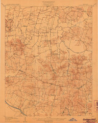 1906 Sutherland1906 Print · USGSDaviess and McLean counties come into focus at the start of the twentieth century, when the rail lines and river forks dictated the pace of rural life. Genealogists and local historians can trace early homes and landmarks near Utica, St Martins Church, and the distinctive Backbone Ridge.3 unique versions available
 - 1953 Map of Sutherland, 1954 Print
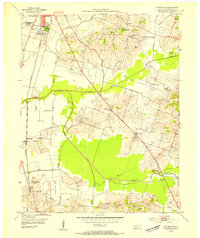 1953 Sutherland1954 Print · USGSDaviess County in the early fifties shows the expansion of Owensboro alongside established rural settlements. Genealogists and historians can trace family locations near Sutherland, Browns Valley, and the campus of Kentucky Wesleyan College.
 - 1954 Map of Evansville
 1954 Evansville1954 Print · USGSThe Ohio River borderlands between Indiana and Kentucky appear here during a period of robust industrial and military growth. Genealogists and researchers can trace the rail corridors of the Illinois Central and find landmarks like US Lock and Dam No 48 or Camp Breckinridge.
 - 1956 Map of Sutherland, 1957 Print
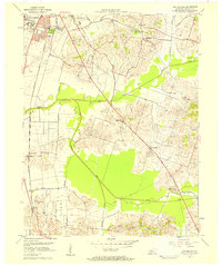 1956 Sutherland1957 Print · USGSDaviess County in the mid-fifties shows the southern growth of Owensboro toward rural farming communities. Genealogists and historians can trace local landmarks like Kentucky Wesleyan College, Masonville, and the Illinois Central rail lines.2 unique versions available
 - 1957 Map of Evansville, 1969 Print
 1957 Evansville1969 Print · USGSIndiana and Kentucky meet along the Ohio River in this mid-century survey of a vital industrial and transport corridor. Genealogists and historians can trace the development of river towns like Owensboro and Newburgh or locate old rail lines like the Southern Ry.3 unique versions available
 - 1961 Map of Evansville
 1961 Evansville1961 Print · USGSThe Ohio River valley and its surrounding coalfields are captured here during the late fifties and early sixties. Trace the industrial rail networks of the Illinois Central RR and explore regional landmarks like Mammoth Cave National Park and Angel Mounds State Memorial.2 unique versions available
 - 1968 Map of Sutherland, 1969 Print
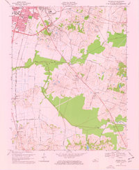 1968 Sutherland1969 Print · USGSOwensboro and the surrounding Daviess County countryside are captured here in the late sixties during a period of steady southward growth. Genealogists and researchers can trace the historic Louisville and Nashville line past Sutherland to find rural landmarks like St Anthonys Cem and the schools of Masonville.3 unique versions available
 - 1986 Map of Evansville
 1986 Evansville1986 Print · USGSThe Ohio River valley thrives in the mid-1980s as a hub of river commerce, industry, and natural preservation spanning the Indiana-Kentucky border. Genealogists and historians can locate remote landmarks like Dead Mans Cem, Lippe Church, and the riverside community of Scuffletown.
 - 1991 Map of Evansville
 1991 Evansville1991 Print · USGSThe tri-state region of Indiana and Kentucky was a hub of river commerce and rail transport in the early nineties. Researchers can trace the industrial corridor between Evansville and Owensboro, locating landmarks like Angel Mounds State Memorial and the Seaboard System railroad.
End of results
Showing maps 1-9 of 9
Top cities near Dermont
- Owensboro historical maps
- Rockport historical maps
- Lewisport historical maps
- Calhoun historical maps
- Grandview historical maps
- Whitesville historical maps
Frequently asked questions
- What are the different types of historical maps available for Dermont?
- What is the oldest map of Dermont?
- Where can I purchase historical maps of Dermont for my home or office?
- Where can I download high-res historical maps of Dermont?
- Are there historical topographic maps available for Dermont?
- Is there historical aerial imagery available for Dermont?
- Where are historical maps of Dermont sourced from?