1900s (20th Century) Maps of Brownsville, Kentucky
Explore 12 historic maps of Brownsville from the 1900s (20th Century). These maps offer a rare glimpse into what life looked like during the 1900s — showing old roads, neighborhoods, homes, and landmarks that have changed or disappeared over time.
Whether you're researching your family's past, planning a metal detecting trip, or studying how Brownsville's landscape evolved across the 1900s, these high-resolution maps are a powerful tool for exploring the history of this region.
- Focus on a specific era: All maps on this page are from the 1900s, giving you a focused view of this time period.
- See what’s changed: Compare century-old streets, trails, and buildings to today's modern landscape using overlays and satellite layers.
- Research with precision: Use these maps for genealogy, historical research, land use analysis, or educational projects.
- View, download, or print: Maps are fully viewable online in high resolution, and can be downloaded or printed for your own records.
Start exploring Brownsville's history through authentic maps from the 1900s. This is your window into the past.
Brownsville, KY maps
(12)- 1922 Map of Brownsville
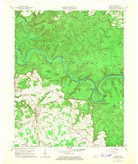
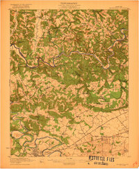 1922 Brownsville1922 Print · USGSEdmonson and Warren Counties are mapped here in the early 1920s, showing a river-centered economy still reliant on ferries and landings. Genealogists can trace family footprints across dozens of country school sites like Poplar Spring School and historic crossings like Sadler Ford.
 - 1922 Map of Mammoth Cave, 1957 Print
 1922 Mammoth Cave1957 Print · USGSThe Green River valley and the Kentucky karst country are captured here in the early 1920s, before the full development of the national park. Researchers can trace family-named landmarks and long-established crossings like Fishtrap Ferry, Good Spring Church, and the world-renowned Mammoth Cave.7 unique versions available
 - 1923 Map of Mammoth Cave
 1923 Mammoth Cave1923 Print · USGSThe subterranean wonders of Edmonson County are mapped in the early 1920s alongside the river ferries and rail towns of the Kentucky karst. Family historians can trace ancestral roots through dozens of local landmarks like Good Spring Church, Ollie School, and Houchins Ferry.6 unique versions available
 - 1923 Map of Brownsville
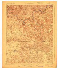
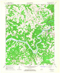
 1923 Brownsville1923 Print · USGSThe river-driven economies of Edmonson and Warren counties are preserved here in the early twentieth century. Researchers can trace ancestral locations through dozens of named sites like Bethlehem Church, Dalton Ferry, and rural schoolhouses including Poplar Spring School.3 unique versions available
 - 1954 Map of Evansville
 1954 Evansville1954 Print · USGSThe Ohio River borderlands between Indiana and Kentucky appear here during a period of robust industrial and military growth. Genealogists and researchers can trace the rail corridors of the Illinois Central and find landmarks like US Lock and Dam No 48 or Camp Breckinridge.
 - 1954 Map of Brownsville, 1955 Print
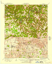
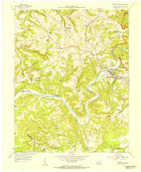 1954 Brownsville1955 Print · USGSCentral Kentucky in the mid-1950s is defined by the winding Green River and the rural communities of Edmonson County. Genealogists and historians can trace family locations near Asphalt Sch, New Home Ch, and the rugged slopes of Shipley Knob.
 - 1954 Map of Rhoda, 1955 Print
 1954 Rhoda1955 Print · USGSThe Green River valley at the edge of the national park comes to life in the mid-fifties, showing the intersection of rural life and protected wilderness. Researchers can trace family sites at Rhoda and Arthur or locate historic congregation points like Beaver Dam Ch and Temple Hill Ch.
 - 1957 Map of Evansville, 1969 Print
 1957 Evansville1969 Print · USGSIndiana and Kentucky meet along the Ohio River in this mid-century survey of a vital industrial and transport corridor. Genealogists and historians can trace the development of river towns like Owensboro and Newburgh or locate old rail lines like the Southern Ry.3 unique versions available
 - 1961 Map of Evansville
 1961 Evansville1961 Print · USGSThe Ohio River valley and its surrounding coalfields are captured here during the late fifties and early sixties. Trace the industrial rail networks of the Illinois Central RR and explore regional landmarks like Mammoth Cave National Park and Angel Mounds State Memorial.2 unique versions available
 - 1965 Map of Brownsville, 1967 Print
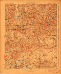
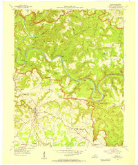
 1965 Brownsville1967 Print · USGSEdmonson County is documented in the mid-1960s as the GREEN RIVER winds through its center near Brownsville. Researchers can trace old family sites and rural landmarks like the Holly Springs Cem, Asphalt, and Gaging Station Lock No 6.
 - 1965 Map of Rhoda, 1967 Print
 1965 Rhoda1967 Print · USGSEdmonson County’s karst landscape is captured here in the mid-sixties, showing the intersection of parkland and rural life. Researchers can trace family history through Silent Grove Ch, Joppa Ch, and the crossing at Houchins Ferry.2 unique versions available
 - 1981 Map of Beaver Dam, 1984 Print
 1981 Beaver Dam1984 Print · USGSThe Western Kentucky coal and river country comes into focus in the early 1980s as industry and recreation reshape the land. Researchers can trace family roots and old routes through Morgantown, Beaver Dam, and the early footprints of Mammoth Cave National Park.
End of results
Showing maps 1-12 of 12
Top cities near Brownsville
- Bowling Green historical maps
- Smiths Grove historical maps
- Caneyville historical maps
- Park City historical maps
- Plum Springs historical maps
- Oakland historical maps
Frequently asked questions
- What are the different types of historical maps available for Brownsville?
- What is the oldest map of Brownsville?
- Where can I purchase historical maps of Brownsville for my home or office?
- Where can I download high-res historical maps of Brownsville?
- Are there historical topographic maps available for Brownsville?
- Is there historical aerial imagery available for Brownsville?
- Where are historical maps of Brownsville sourced from?