Old Maps of Fleming County, Kentucky for Academic Research
Study the evolution of Fleming County with 96 high-resolution historic maps. Whether you're teaching, researching, or modeling changes in land use, these maps provide essential visual documentation of urban, environmental, and geographic change.
- Analyze long-term change: Track patterns in development, transportation, and natural features.
- Ideal for environmental or urban studies: Support academic projects with primary historical map data.
- Use in the classroom or lab: Educators and researchers rely on these maps to bring historical context to life.
These maps are a powerful tool for teaching, research, and visualizing how Fleming County has changed over the decades.
Fleming County, KY maps
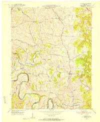
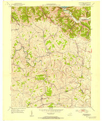
(96)- 1929 Map of Springdale
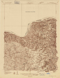 1929 Springdale1929 Print · USGSThe Ohio River valley and Kentucky's northern hills are captured here in the late twenties, showing a landscape defined by the Chesapeake and Ohio railroad. Genealogists can trace early homesteads and landmarks near Tollesboro, Ruggles Camp, and the many rural sites like Ebenezer Ch.2 unique versions available
 - 1929 Map of Salt Lick, 1961 Print
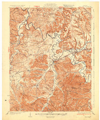
 1929 Salt Lick1961 Print · USGSBath and Fleming counties are shown here as the Licking River valley was transitioning into a modern rail corridor. Genealogists and historians can trace numerous rural schoolhouses and river crossings like Moores Ferry, Arnold Chapel, and the historic Olympia Springs.
 - 1934 Map of Salt Lick
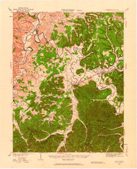
 1934 Salt Lick1934 Print · USGSNortheastern Kentucky’s river valleys and ridgelines are captured here in the 1930s, centered on the vital rail corridor through Salt Lick. Genealogists and historians can trace dozens of rural schoolhouses and churches, including Arnold Chapel Sch, Olympia Springs, and Moores Ferry on the Licking River.
 - 1935 Map of Springdale
 1935 Springdale1935 Print · USGSThe Ohio River valley at the height of the mid-1930s reveals a landscape shaped by river commerce and the Chesapeake and Ohio railroad. Researchers can locate numerous vanished country schools like Hamilton School, the infrastructure of Dam 33, and rural centers such as Tollesboro.
 - 1951 Map of Cranston, 1953 Print
 1951 Cranston1953 Print · USGSRowan County in the early fifties shows a landscape of deep hollows and rural outposts within the Cumberland National Forest. Genealogists can trace family lines through sites like McRoberts Cem and schools such as Rock Fork Sch.2 unique versions available
 - 1951 Map of Hillsboro, 1953 Print
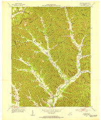
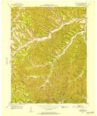
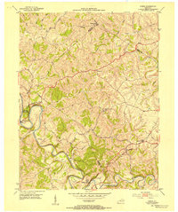
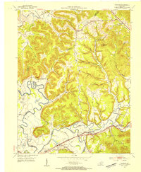
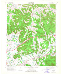
 1951 Hillsboro1953 Print · USGSFleming and Bath counties are surveyed here in the early fifties, showcasing the intricate bends of the Licking River. Genealogists and local historians can trace rural roots through the Hillsboro Cem, the settlement of Poplar Plains, and the grounds of Mt Hope Camp.5 unique versions available
 - 1951 Map of Stricklett, 1953 Print
 1951 Stricklett1953 Print · USGSLewis County in the early fifties is mapped here as a network of creek-side communities and upland lookouts. Researchers can find old schools and churches like Kinniconick Sch, Thackers Chapel, and Union Ch along the winding Kinniconick Creek.4 unique versions available
 - 1951 Map of Plummers Landing, 1953 Print
 1951 Plummers Landing1953 Print · USGSFleming and Rowan counties are captured in the early fifties, showing a rural Kentucky landscape of mill towns and winding creeks. Genealogists can trace family names through landmarks like Daulton Sch, Goddard, and the mill sites at Ringos Mills.3 unique versions available
 - 1951 Map of Burtonville, 1953 Print
 1951 Burtonville1953 Print · USGSThe Fleming and Lewis County borderlands in the early fifties were a network of ridge-top farms and deep creek-bottom settlements. Genealogists and local historians can trace family locations through Mays Cem, Pleasant Valley Ch, and the many hollows branching off Kinniconick Creek.3 unique versions available
 - 1951 Map of Flemingsburg, 1953 Print
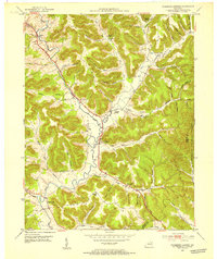
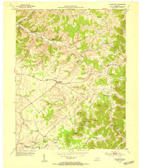
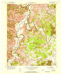
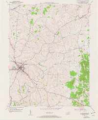 1951 Flemingsburg1953 Print · USGSThe county seat of Flemingsburg and its surrounding Kentucky farmland are captured here in the early fifties, showing a landscape defined by rail lines and rural junctions. Genealogists can trace family locations through Fitche Chapel Cem, Arnold Cem, and the path of the Flemingsburg and Northern railroad.3 unique versions available
 - 1952 Map of Cowan, 1953 Print
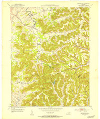
 1952 Cowan1953 Print · USGSThe rural landscapes of Fleming and Nicholas counties are captured here in the early fifties, centered on the winding Licking River. Genealogists and historians can locate family landmarks such as Cowan, Blue Licks Spr, and Furman Chapel Ch.3 unique versions available
 - 1952 Map of Sherburne, 1953 Print
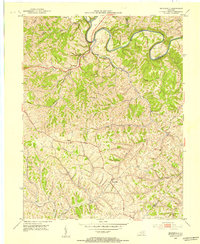
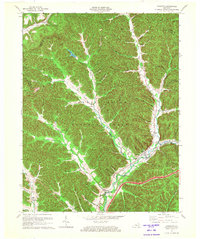
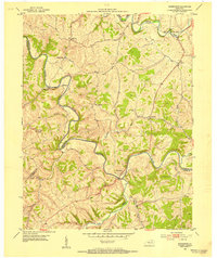 1952 Sherburne1953 Print · USGSThe Licking River valley at the border of Fleming, Bath, and Nicholas counties is captured here in the early 1950s. Family historians can trace rural roots through numerous burial sites like Gilead Cem and Porter Cem, or locate old river settlements like Sherburne and Marthas Mills.
 - 1952 Map of Elizaville, 1953 Print
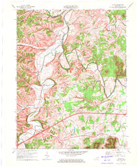
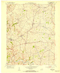 1952 Elizaville1953 Print · USGSFleming and Mason counties appear here in the early fifties, showing the rural Kentucky landscape before the era of modern highway expansion. Genealogists and local historians can trace family ties at Clover Hill Ch or locate old rail stops like Flemingsburg Junction and Nepton.3 unique versions available
 - 1952 Map of Orangeburg, 1954 Print
 1952 Orangeburg1954 Print · USGSMason County hill country in the early fifties is mapped here, showing the rural life centered on the North Fork Licking River. Genealogists can locate family landmarks like Stone Lick Ch, Antioch Ch, and the hamlet of Orangeburg.3 unique versions available
 - 1953 Map of Farmers, 1954 Print
 1953 Farmers1954 Print · USGSThe borderlands of Rowan, Bath, and Fleming counties are captured here in the early fifties, centered on the rail-and-river hub of Farmers. Local researchers can trace family roots through sites like Jones Cemetery, Moores Ferry, and the Three Lick School.2 unique versions available
 - 1953 Map of Moorefield, 1954 Print
 1953 Moorefield1954 Print · USGSNicholas County and its borderlands in the early fifties show a rural landscape defined by the deep bends of the Licking River. Researchers can trace old family sites and rural landmarks like Parrish Chapel Cemetery and the settlement of Moorefield.2 unique versions available
 - 1953 Map of Tollesboro, 1954 Print
 1953 Tollesboro1954 Print · USGSLewis County hills and hollows are captured in the early fifties, showing a rural landscape defined by ridge-top farms and creek-side hamlets. Researchers can trace family roots through Tollesboro and locate landmarks like Canaan Sch and Eskalapia Mountain.2 unique versions available
 - 1953 Map of Colfax, 1955 Print
 1953 Colfax1955 Print · USGSBath and Fleming Counties during the early fifties show a landscape of winding river valleys and ridge-top schools. Genealogists can trace family names at the Atchison Cem or locate community centers like Slate Valley and Baileys Chapel.
 - 1957 Map of Huntington, 1966 Print
 1957 Huntington1966 Print · USGSThe industrial heart of the Ohio River valley is captured here in the mid-sixties, showing the growth of Huntington and Ashland. Researchers can trace the extensive rail networks of the Chesapeake and Ohio RR and locate sites like the Chief Cornstalk Hunting Ground.3 unique versions available
 - 1960 Map of Huntington
 1960 Huntington1960 Print · USGSThe tri-state river valley thrived in the late fifties as a hub of heavy industry and Appalachian rail transit. Genealogists and historians can trace the connection between river towns like Ashland and Portsmouth or locate family homesteads near Coleman Ridge.
 - 1970 Map of Farmers, 1972 Print
 1970 Farmers1972 Print · USGSRowan and Bath counties in the early seventies reveal a landscape of river-bend settlements and deep forest ridges. Genealogists and locals can trace family sites like Eldridge Cem, find the old crossing at Moores Ferry, and follow the Chesapeake and Ohio rail line.2 unique versions available
 - 1970 Map of Colfax, 1972 Print
 1970 Colfax1972 Print · USGSBath and Fleming Counties appear here in the early seventies, as rural life moved along the high ridges and deep hollows of the Licking River. Genealogists and historians can trace local family lineages through remote sites like Old Virginia Cem, Grange City, and Atchison Cem.2 unique versions available
 - 1970 Map of Cranston, 1972 Print
 1970 Cranston1972 Print · USGSThe Daniel Boone National Forest in the 1970s reveals a landscape of isolated hollows and ridge-top lookouts. Genealogists can locate family landmarks like Evans Cem and rural centers such as Cranston, Smile, and the Hickory Flats Lookout Tower.
 - 1982 Map of Morehead, 1983 Print
 1982 Morehead1983 Print · USGSThe foothills of northeastern Kentucky come alive in the early eighties, showcasing a landscape defined by timber, limestone caves, and major reservoirs. Local researchers can trace the development of Morehead State University or locate old crossings at Plummers Mill and Salt Lick.
 - 1986 Map of Maysville
 1986 Maysville1986 Print · USGSThe Ohio River valley in the mid-eighties reveals a landscape of industrial river towns and sprawling public lands spanning the Kentucky and Ohio border. Researchers can trace the rail corridors of the Chesapeake and Ohio Railway or locate landmarks like Confidence Cemetery and the Fleming-Mason Airport.
Showing maps 1-25 of 96
Top cities of Fleming County
Frequently asked questions
- What are the different types of historical maps available for Fleming County?
- What is the oldest map of Fleming County?
- Where can I purchase historical maps of Fleming County for my home or office?
- Where can I download high-res historical maps of Fleming County?
- Are there historical topographic maps available for Fleming County?
- Is there historical aerial imagery available for Fleming County?
- Where are historical maps of Fleming County sourced from?