
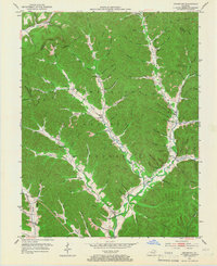
1951 Map of Cranston
USGS Topo · Published 1953About this map
Cumberland National Forest dominates this 1951 topographic study of the Rowan County landscape, revealing a dense network of mountain hollows and ridge-top lookouts like Hickory Flats Lookout. The terrain is characterized by winding drainages and narrow valley floors where small farming communities and educational centers took root. Local genealogy is well-preserved through numerous named burial grounds and rural institutions, including McRoberts Cem, Whisman Cem, and the Adams-Davis Sch.
Find a feature on this map
107 named features on this map. Tap any name to fly to it.
Don’t see what you’re looking for? This feature index may not catch every label — zoom into the map to look around manually.
Map Details
Editions of this 1951 Cranston Map
2 editions found
Other maps of this area

1929 · Morehead
USGS Topo · 1:48,000

1929 · Salt Lick
USGS Topo · 1:62,500

1934 · Salt Lick
USGS Topo · 1:62,500

1935 · Morehead
USGS Topo · 1:62,500

1950 · Head Of Grassy
USGS Topo · 1:24,000

1951 · Soldier
USGS Topo · 1:24,000

1951 · Stricklett
USGS Topo · 1:24,000

1951 · Plummers Landing
USGS Topo · 1:24,000

1951 · Burtonville
USGS Topo · 1:24,000

1953 · Haldeman
USGS Topo · 1:24,000