
1950 Map of Head Of Grassy
USGS Topo · Published 1952About this map
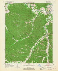
Kinniconick Creek winds through the northern portion of this 1950 Lewis County landscape, providing the primary drainage for a network of hollows and lick branches. The settlement of Camp Dix serves as a local hub near the creek, while smaller communities like Blankenship and Brighton are nestled along the valley floor. The map illustrates a rural society deeply connected to its local institutions, evidenced by the high density of neighborhood-specific facilities such as Blankenship Sch, Mosby Sch, and Tar Fork Sch.
Find a feature on this map
94 named features on this map. Tap any name to fly to it.
Don’t see what you’re looking for? This feature index may not catch every label — zoom into the map to look around manually.
Map Details
Editions of this 1950 Head Of Grassy Map
3 editions found
Other maps of this area

1915 · Garrison
USGS Topo · 1:62,500

1918 · Garrison
USGS Topo · 1:62,500

1919 · Vanceburg
USGS Topo · 1:62,500

1949 · Vanceburg
USGS Topo · 1:62,500

1949 · Garrison
USGS Topo · 1:24,000

1949 · Vanceburg
USGS Topo · 1:24,000

1949 · Charters
USGS Topo · 1:24,000

1950 · Charters
USGS Topo · 1:24,000

1950 · Wesleyville
USGS Topo · 1:24,000

1950 · Olive Hill
USGS Topo · 1:24,000