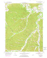
1950 Map of Head of Grassy
USGS Topo · Published 1978About this map
Kinniconick Creek and its many winding tributaries define the landscape of Lewis County during the mid-20th century. The settlement of Camp Dix serves as a northern anchor point, while the eponymous Head of Grassy marks the southern reach, illustrating the dispersed rural community structure of the era. The mapping of numerous hollows and branches, such as Mosby Hollow and Pigeon Roost Hollow, provides a fine-grained look at the local topography and naming conventions.
Find a feature on this map
92 named features on this map. Tap any name to fly to it.
Don’t see what you’re looking for? This feature index may not catch every label — zoom into the map to look around manually.
Map Details
Editions of this 1950 Head of Grassy Map
3 editions found
Other maps of this area

1915 · Garrison
USGS Topo · 1:62,500

1918 · Garrison
USGS Topo · 1:62,500

1919 · Vanceburg
USGS Topo · 1:62,500

1949 · Vanceburg
USGS Topo · 1:62,500

1949 · Garrison
USGS Topo · 1:24,000

1949 · Vanceburg
USGS Topo · 1:24,000

1949 · Charters
USGS Topo · 1:24,000

1950 · Charters
USGS Topo · 1:24,000

1950 · Head Of Grassy
USGS Topo · 1:24,000

1950 · Wesleyville
USGS Topo · 1:24,000