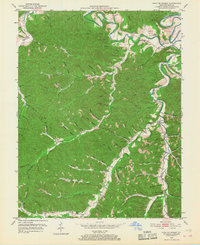
1950 Map of Head Of Grassy
USGS Topo · Published 1968About this map
Kinniconick Creek and its many winding tributaries dictate the life and layout of this Lewis County landscape in 1950. The terrain is deeply incised by countless hollows and branches, such as Pell Hollow, Mill Hollow, and Buckner Hol, where small settlements and homesteads found level ground. Local community life is anchored by a network of rural institutions, including Blankenship Ch, Saylor Branch Ch, and several mountain schools like Mosby Sch and Raccoon Sch. The survey shows the area during a period of transition, where the Huckleberry Tower stands as a sentinel over the wooded ridges, while small hamlets like Camp Dix and the namesake Head of Grassy serve as the primary crossroads for the region's residents.
Find a feature on this map
97 named features on this map. Tap any name to fly to it.
Don’t see what you’re looking for? This feature index may not catch every label — zoom into the map to look around manually.
Map Details
Editions of this 1950 Head Of Grassy Map
3 editions found
Other maps of this area

1915 · Garrison
USGS Topo · 1:62,500

1918 · Garrison
USGS Topo · 1:62,500

1919 · Vanceburg
USGS Topo · 1:62,500

1949 · Vanceburg
USGS Topo · 1:62,500

1949 · Garrison
USGS Topo · 1:24,000

1949 · Vanceburg
USGS Topo · 1:24,000

1949 · Charters
USGS Topo · 1:24,000

1950 · Charters
USGS Topo · 1:24,000

1950 · Head Of Grassy
USGS Topo · 1:24,000

1950 · Wesleyville
USGS Topo · 1:24,000