1920s Maps of Farmdale, Kentucky
Explore 2 historic maps of Farmdale from the 1920s. These maps offer a rare glimpse into what life looked like during the 1920s — showing old roads, neighborhoods, homes, and landmarks that have changed or disappeared over time.
Whether you're researching your family's past, planning a metal detecting trip, or studying how Farmdale's landscape evolved across the 1920s, these high-resolution maps are a powerful tool for exploring the history of this region.
- Focus on a specific era: All maps on this page are from the 1920s, giving you a focused view of this time period.
- See what’s changed: Compare century-old streets, trails, and buildings to today's modern landscape using overlays and satellite layers.
- Research with precision: Use these maps for genealogy, historical research, land use analysis, or educational projects.
- View, download, or print: Maps are fully viewable online in high resolution, and can be downloaded or printed for your own records.
Start exploring Farmdale's history through authentic maps from the 1920s. This is your window into the past.
Farmdale, KY maps
(2)- 1922 Map of Frankfort
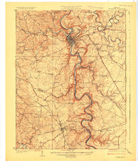
 1922 Frankfort1922 Print · USGSCentral Kentucky's river valleys and rolling uplands are captured here in the early twenties, showing a landscape defined by water and rail. Trace family history at Lanes Mill Fox Gap School or follow the river to Youngs High Bridge and Shryocks Ferry.
 - 1924 Map of Frankfort
 1924 Frankfort1924 Print · USGSThe Kentucky River valley and surrounding Bluegrass uplands are documented here during the mid-1920s. Genealogists and researchers can trace rural life through dozens of named district schools and river landmarks like Youngs High Bridge, Lanes Mill, and Shryocks Ferry.2 unique versions available
End of results
Showing maps 1-2 of 2
Top cities near Farmdale
- Frankfort historical maps
- Lawrenceburg historical maps
- Versailles historical maps
- Midway historical maps
- Stamping Ground historical maps
Frequently asked questions
- What are the different types of historical maps available for Farmdale?
- What is the oldest map of Farmdale?
- Where can I purchase historical maps of Farmdale for my home or office?
- Where can I download high-res historical maps of Farmdale?
- Are there historical topographic maps available for Farmdale?
- Is there historical aerial imagery available for Farmdale?
- Where are historical maps of Farmdale sourced from?