2020s Maps of Frankfort, Kentucky
Explore 2 historic maps of Frankfort from the 2020s. These maps offer a rare glimpse into what life looked like during the 2020s — showing old roads, neighborhoods, homes, and landmarks that have changed or disappeared over time.
Whether you're researching your family's past, planning a metal detecting trip, or studying how Frankfort's landscape evolved across the 2020s, these high-resolution maps are a powerful tool for exploring the history of this region.
- Focus on a specific era: All maps on this page are from the 2020s, giving you a focused view of this time period.
- See what’s changed: Compare century-old streets, trails, and buildings to today's modern landscape using overlays and satellite layers.
- Research with precision: Use these maps for genealogy, historical research, land use analysis, or educational projects.
- View, download, or print: Maps are fully viewable online in high resolution, and can be downloaded or printed for your own records.
Start exploring Frankfort's history through authentic maps from the 2020s. This is your window into the past.
Frankfort, KY maps
(2)- 2022 Map of Frankfort West, 2022 Print
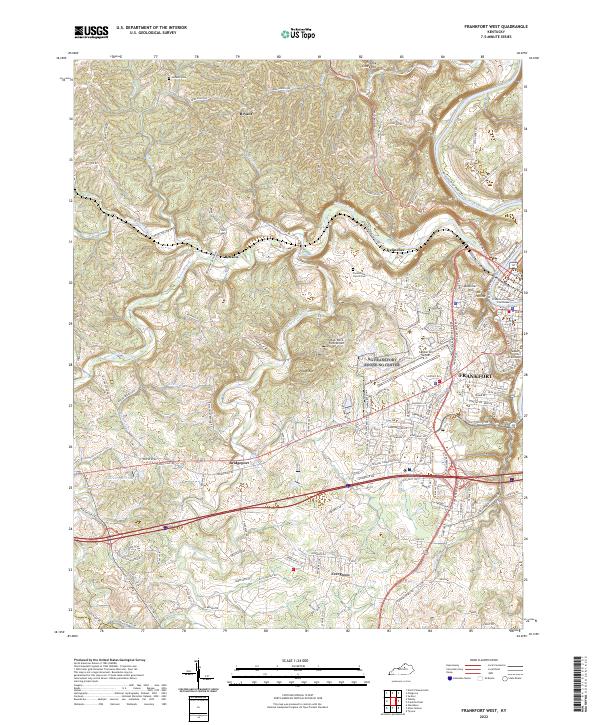 2022 Frankfort West2022 Print · USGSFrankfort and the Kentucky River valley are shown here in the 2020s, highlighting the state capital alongside rural Franklin County. Researchers can locate the Franklin County Courthouse, trace family ties at Choateville Church Cem, and explore old routes near Bridgeport.
 - 2022 Map of Frankfort East, 2022 Print
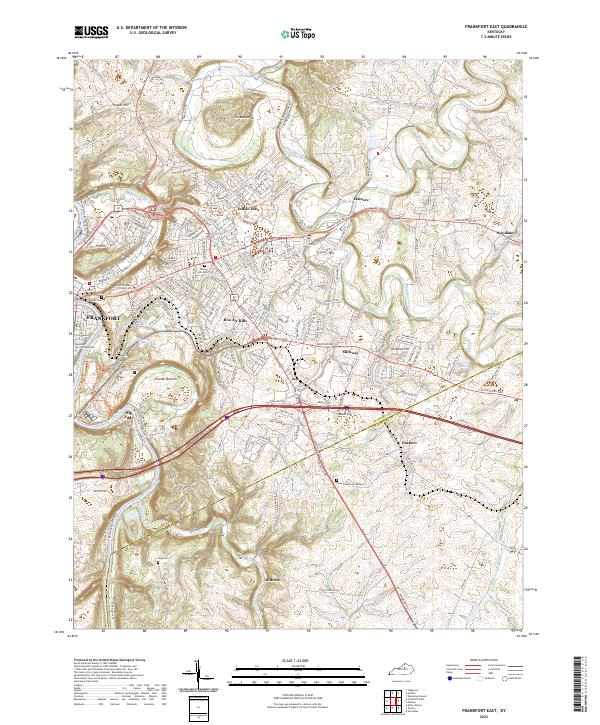 2022 Frankfort East2022 Print · USGSThe state capital and its surrounding Bluegrass hills are captured here in the early 2020s as the riverfront and suburbs continue to evolve. Researchers can locate the historic Frankfort Cem, trace the bends of Elkhorn Creek, and find smaller settlements like Duckers and Millville.
End of results
Showing maps 1-2 of 2
Top cities near Frankfort
- Lexington historical maps
- Lawrenceburg historical maps
- Versailles historical maps
- Midway historical maps
- Stamping Ground historical maps
- Monterey historical maps
Top neighborhoods of Frankfort
Frequently asked questions
- What are the different types of historical maps available for Frankfort?
- What is the oldest map of Frankfort?
- Where can I purchase historical maps of Frankfort for my home or office?
- Where can I download high-res historical maps of Frankfort?
- Are there historical topographic maps available for Frankfort?
- Is there historical aerial imagery available for Frankfort?
- Where are historical maps of Frankfort sourced from?