1950s Maps of Gallatin County, Kentucky
Explore 8 historic maps of Gallatin County from the 1950s. These maps offer a rare glimpse into what life looked like during the 1950s — showing old roads, neighborhoods, homes, and landmarks that have changed or disappeared over time.
Whether you're researching your family's past, planning a metal detecting trip, or studying how Gallatin County's landscape evolved across the 1950s, these high-resolution maps are a powerful tool for exploring the history of this region.
- Focus on a specific era: All maps on this page are from the 1950s, giving you a focused view of this time period.
- See what’s changed: Compare century-old streets, trails, and buildings to today's modern landscape using overlays and satellite layers.
- Research with precision: Use these maps for genealogy, historical research, land use analysis, or educational projects.
- View, download, or print: Maps are fully viewable online in high resolution, and can be downloaded or printed for your own records.
Start exploring Gallatin County's history through authentic maps from the 1950s. This is your window into the past.
Gallatin County, KY maps
(8)- 1950 Map of Glencoe, 1952 Print
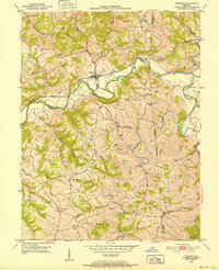 1950 Glencoe1952 Print · USGSThe rural borders of Gallatin, Owen, and Grant Counties come alive in the early fifties, centered on the railroad hub of Glencoe. Genealogists can trace family roots through numerous local sites like the I O O F Cem, Slab Lick Sch, and Pleasant Home Ch.2 unique versions available
 - 1950 Map of Verona, 1952 Print
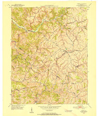 1950 Verona1952 Print · USGSNorthern Kentucky’s rolling hills come alive in this mid-century survey, showcasing the rural intersections where Boone, Gallatin, and Grant Counties meet. Genealogists can trace family names at St Patricks Cem or locate the old rail-stop at Zion Station.
 - 1951 Map of Florence, 1953 Print
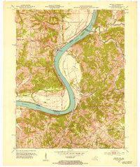
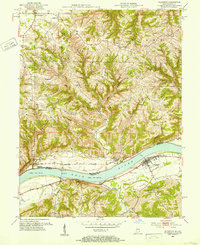 1951 Florence1953 Print · USGSThe Ohio River valley at mid-century reveals a landscape of ridge-top farms and riverfront commerce between Indiana and Kentucky. Researchers can trace historic ferry crossings at Florence, family burial sites like Gridley Cem, and early aviation at Warsaw Airfield.
 - 1951 Map of Sanders, 1953 Print
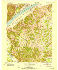
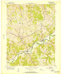 1951 Sanders1953 Print · USGSNorthern Kentucky in the early fifties was defined by the steam and steel of the Louisville and Nashville railroad as it wound through the Eagle Creek valley. Genealogists can locate family landmarks like Furnish Cem, Drury Chapel, and the remote Park Ridge Sch.
 - 1951 Map of Patriot, 1953 Print
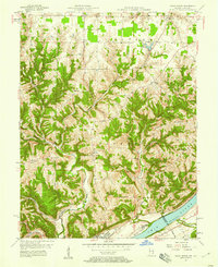
 1951 Patriot1953 Print · USGSThe Indiana-Kentucky border along the Ohio River is captured here in the early fifties, showing a landscape of fertile river bottoms and upland farms. Genealogists can trace family roots at Patriot or locate rural landmarks like Searcy Crossroads, Concord Ch, and McNutt Cem.
 - 1952 Map of Vevay South, 1954 Print
 1952 Vevay South1954 Print · USGSThe Ohio River valley at the Indiana-Kentucky border was a landscape of riverfront hubs and isolated hill settlements in the early fifties. Genealogists and historians can trace family plots at O'Neal Cem or Stafford Cem and locate rural landmarks like Marvin Chapel and the Easterday settlement.2 unique versions available
 - 1956 Map of Louisville, 1971 Print
 1956 Louisville1971 Print · USGSThe Ohio River valley and the Kentucky Bluegrass are captured here during a period of rapid mid-century growth and industrial activity. Genealogists and historians can trace rail-centered towns and military land use at Fort Knox and the Jefferson Proving Ground.2 unique versions available
 - 1957 Map of Vevay North, 1958 Print
 1957 Vevay North1958 Print · USGSThe Ohio River hills of Switzerland County come alive in the late 1950s, showing the intricate landscape of ridges and creek beds. Researchers can find old rural landmarks like Plum Creek Ch, the river town of Vevay, and the aptly named Popcorn Ridge.2 unique versions available
End of results
Showing maps 1-8 of 8
Top cities of Gallatin County
Frequently asked questions
- What are the different types of historical maps available for Gallatin County?
- What is the oldest map of Gallatin County?
- Where can I purchase historical maps of Gallatin County for my home or office?
- Where can I download high-res historical maps of Gallatin County?
- Are there historical topographic maps available for Gallatin County?
- Is there historical aerial imagery available for Gallatin County?
- Where are historical maps of Gallatin County sourced from?