1950s Maps of Mayfield, Kentucky
Explore 7 historic maps of Mayfield from the 1950s. These maps offer a rare glimpse into what life looked like during the 1950s — showing old roads, neighborhoods, homes, and landmarks that have changed or disappeared over time.
Whether you're researching your family's past, planning a metal detecting trip, or studying how Mayfield's landscape evolved across the 1950s, these high-resolution maps are a powerful tool for exploring the history of this region.
- Focus on a specific era: All maps on this page are from the 1950s, giving you a focused view of this time period.
- See what’s changed: Compare century-old streets, trails, and buildings to today's modern landscape using overlays and satellite layers.
- Research with precision: Use these maps for genealogy, historical research, land use analysis, or educational projects.
- View, download, or print: Maps are fully viewable online in high resolution, and can be downloaded or printed for your own records.
Start exploring Mayfield's history through authentic maps from the 1950s. This is your window into the past.
Mayfield, KY maps
(7)- 1951 Map of Farmington, 1955 Print
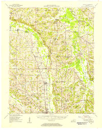
 1951 Farmington1955 Print · USGSGraves County, Kentucky, is shown in detail during the early fifties, following the ridge of the Tennessee Valley Divide. Researchers can trace family roots through numerous local landmarks, including Sedalia Sch, Bethlehem Church, and Swann Cem.3 unique versions available
 - 1951 Map of Hickory, 1956 Print
 1951 Hickory1956 Print · USGSGraves County at mid-century centers on the busy Illinois Central Railroad and the rural communities north of Mayfield. Researchers can trace dozens of family burial sites like Albritton Cem or visit local landmarks like the County War Memorial Fairgrounds.2 unique versions available
 - 1951 Map of Westplains, 1956 Print
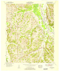 1951 Westplains1956 Print · USGSGraves County in the early 1950s is a landscape of high ridges and winding river bottoms divided by the Tennessee Valley Divide. Researchers can locate numerous family landmarks and rural hubs, including Spence Chapel, the Hardeman Sch, and the Old Casey Bridge.2 unique versions available
 - 1951 Map of Hickory, 1957 Print
 1951 Hickory1957 Print · USGSIn the early 1950s, this area of Graves and McCracken County was a patchwork of small tobacco farms and rail-stop towns. Researchers can locate hundreds of family sites, from the Clay Pits near Hickory to remote landmarks like Neece Chapel and Old Casey Bridge.
 - 1952 Map of Mayfield, 1953 Print
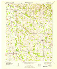
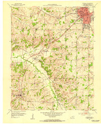 1952 Mayfield1953 Print · USGSMid-century Graves County is centered on the industrial and rail hub of Mayfield, where the railroad connects the town to its rural southern neighbors. Genealogists can locate family names and burial sites at Maplewood Cem, Bethel Cem, and the small settlement of Pryorsburg.
 - 1952 Map of Mayfield, 1957 Print
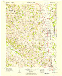
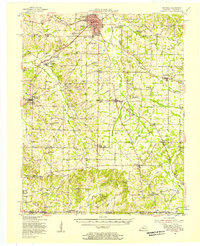 1952 Mayfield1957 Print · USGSGraves County, Kentucky, was a bustling network of rail-side towns and rural parishes at the mid-century. Researchers can trace family history through dozens of landmarks like Rozzell Cem, follow the Illinois Central Railroad, or locate the County Farm.
 - 1956 Map of Dyersburg, 1960 Print
 1956 Dyersburg1960 Print · USGSThe Four Rivers region comes alive in the mid-fifties, capturing the intricate borderlands of Tennessee, Kentucky, and Missouri. Genealogists and historians can trace the rail-and-river networks connecting Dyersburg, Caruthersville, and the shoreline of Reelfoot Lake.4 unique versions available
End of results
Showing maps 1-7 of 7
Top cities near Mayfield
Frequently asked questions
- What are the different types of historical maps available for Mayfield?
- What is the oldest map of Mayfield?
- Where can I purchase historical maps of Mayfield for my home or office?
- Where can I download high-res historical maps of Mayfield?
- Are there historical topographic maps available for Mayfield?
- Is there historical aerial imagery available for Mayfield?
- Where are historical maps of Mayfield sourced from?