1900s (20th Century) Maps of Wingo, Kentucky
Explore 9 historic maps of Wingo from the 1900s (20th Century). These maps offer a rare glimpse into what life looked like during the 1900s — showing old roads, neighborhoods, homes, and landmarks that have changed or disappeared over time.
Whether you're researching your family's past, planning a metal detecting trip, or studying how Wingo's landscape evolved across the 1900s, these high-resolution maps are a powerful tool for exploring the history of this region.
- Focus on a specific era: All maps on this page are from the 1900s, giving you a focused view of this time period.
- See what’s changed: Compare century-old streets, trails, and buildings to today's modern landscape using overlays and satellite layers.
- Research with precision: Use these maps for genealogy, historical research, land use analysis, or educational projects.
- View, download, or print: Maps are fully viewable online in high resolution, and can be downloaded or printed for your own records.
Start exploring Wingo's history through authentic maps from the 1900s. This is your window into the past.
Wingo, KY maps
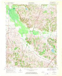
(9)- 1952 Map of Mayfield, 1953 Print
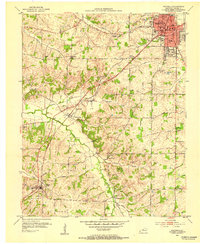 1952 Mayfield1953 Print · USGSMid-century Graves County is centered on the industrial and rail hub of Mayfield, where the railroad connects the town to its rural southern neighbors. Genealogists can locate family names and burial sites at Maplewood Cem, Bethel Cem, and the small settlement of Pryorsburg.
 - 1952 Map of Dublin, 1953 Print
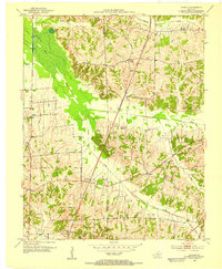 1952 Dublin1953 Print · USGSGraves and Hickman counties come together in this early 1950s survey of the Jackson Purchase. Genealogists can trace family names and rural hubs including Dublin, the Illinois Central rail line, and numerous landmarks like McClure Chapel and Mason Cem.
 - 1952 Map of Mayfield, 1957 Print
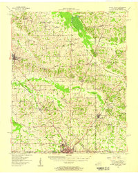
 1952 Mayfield1957 Print · USGSGraves County, Kentucky, was a bustling network of rail-side towns and rural parishes at the mid-century. Researchers can trace family history through dozens of landmarks like Rozzell Cem, follow the Illinois Central Railroad, or locate the County Farm.
 - 1952 Map of Water Valley, 1957 Print
 1952 Water Valley1957 Print · USGSWestern Kentucky and northern Tennessee are captured here in the early fifties as the Illinois Central railroad linked farming hubs and small towns. Genealogists can trace family names through dozens of landmarks like Camp Beauregard Cem, McWhort Cem, and Shiloh Sch Ch.
 - 1956 Map of Dyersburg, 1960 Print
 1956 Dyersburg1960 Print · USGSThe Four Rivers region comes alive in the mid-fifties, capturing the intricate borderlands of Tennessee, Kentucky, and Missouri. Genealogists and historians can trace the rail-and-river networks connecting Dyersburg, Caruthersville, and the shoreline of Reelfoot Lake.4 unique versions available
 - 1969 Map of Dublin, 1970 Print
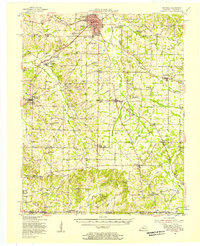
 1969 Dublin1970 Print · USGSWestern Kentucky farming life near the border of Hickman and Graves counties is captured here in the late sixties. Genealogists and local historians can trace family locations near Watts Station, find the Salem Ch Cem, or follow the Illinois Central Railroad.2 unique versions available
 - 1969 Map of Mayfield, 1971 Print
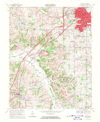 1969 Mayfield1971 Print · USGSGraves County during the late sixties shows the expansion of MAYFIELD alongside traditional rural life. Genealogists can trace family names at St Josephs Cem or Dodson Cem and locate rural landmarks like Pryorsburg and Shady Grove Ch.2 unique versions available
 - 1986 Map of Murray
 1986 Murray1986 Print · USGSWestern Kentucky in the mid-1980s reveals a landscape defined by the Tennessee and Cumberland rivers. Genealogists and historians can trace rail-town development along the Illinois Central Gulf RR and find family-named locations like Dukedom and Water Valley.2 unique versions available
 - 1994 Map of Mayfield, 1996 Print
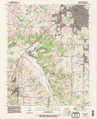 1994 Mayfield1996 Print · USGSIn the mid-1990s, Graves County remained a hub of rail transport and clay mining around the city of Mayfield. Trace family roots and old property lines near Pryorsburg, Rozzelle Church, and the Illinois Central Railroad.
End of results
Showing maps 1-9 of 9
Top cities near Wingo
- Mayfield historical maps
- Fulton historical maps
- South Fulton historical maps
- Water Valley historical maps
Frequently asked questions
- What are the different types of historical maps available for Wingo?
- What is the oldest map of Wingo?
- Where can I purchase historical maps of Wingo for my home or office?
- Where can I download high-res historical maps of Wingo?
- Are there historical topographic maps available for Wingo?
- Is there historical aerial imagery available for Wingo?
- Where are historical maps of Wingo sourced from?