1960s Maps of Grayson County, Kentucky
Explore 13 historic maps of Grayson County from the 1960s. These maps offer a rare glimpse into what life looked like during the 1960s — showing old roads, neighborhoods, homes, and landmarks that have changed or disappeared over time.
Whether you're researching your family's past, planning a metal detecting trip, or studying how Grayson County's landscape evolved across the 1960s, these high-resolution maps are a powerful tool for exploring the history of this region.
- Focus on a specific era: All maps on this page are from the 1960s, giving you a focused view of this time period.
- See what’s changed: Compare century-old streets, trails, and buildings to today's modern landscape using overlays and satellite layers.
- Research with precision: Use these maps for genealogy, historical research, land use analysis, or educational projects.
- View, download, or print: Maps are fully viewable online in high resolution, and can be downloaded or printed for your own records.
Start exploring Grayson County's history through authentic maps from the 1960s. This is your window into the past.
Grayson County, KY maps
(13)- 1960 Map of Big Clifty, 1961 Print
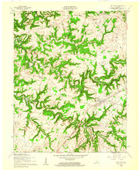 1960 Big Clifty1961 Print · USGSGrayson and Hardin counties are shown in the early sixties as the railroad and river define the local pace of life. Researchers can trace family sites like St Pauls Ch, the Johnson School, and small rail stops from Big Clifty to West Clifty.
 - 1960 Map of Summit, 1962 Print
 1960 Summit1962 Print · USGSHardin County is captured in the early sixties as a rural landscape shaped by the Illinois Central railroad and the twisting Nolin River. Researchers can trace ancestral roots through the Duncan Cem or locate community centers like White Mills and Antioch Ch.
 - 1961 Map of Evansville
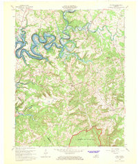
 1961 Evansville1961 Print · USGSThe Ohio River valley and its surrounding coalfields are captured here during the late fifties and early sixties. Trace the industrial rail networks of the Illinois Central RR and explore regional landmarks like Mammoth Cave National Park and Angel Mounds State Memorial.2 unique versions available
 - 1963 Map of Mc Daniels, 1964 Print
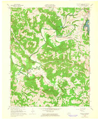
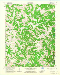
 1963 Mc Daniels1964 Print · USGSBreckinridge and Grayson Counties are shown here during the mid-twentieth century as the newly formed Rough River Reservoir transformed the local valleys. Researchers can locate vanished rural landmarks and family-named sites like Horn Back Mill, Johnson Sch, and Poole Cem.3 unique versions available
 - 1963 Map of Falls of Rough, 1965 Print
 1963 Falls of Rough1965 Print · USGSThe Rough River region in the early sixties shows a landscape undergoing change as the new reservoir and Rough River Dam State Park take shape. Researchers can trace ancestral roots through remote sites like Iron Ore Hill Cem and Lone Hill Ch.
 - 1963 Map of Madrid, 1976 Print
 1963 Madrid1976 Print · USGSGrayson and Breckinridge Counties are captured here in the early sixties as the reservoir waters of Rough River Lake reshaped the valley. Trace local roots at sites like Antioch Ch, Mullins Cem, and the old Conklin Sch.2 unique versions available
 - 1966 Map of Cub Run, 1968 Print
 1966 Cub Run1968 Print · USGSCentral Kentucky's rural landscape is captured here in the mid-1960s as the Nolin River Reservoir reshaped the valley. Researchers can trace old family sites near Cub Run, Big Windy, and rural pulpits like St Benedicts Ch.
 - 1966 Map of Bee Spring, 1968 Print
 1966 Bee Spring1968 Print · USGSThe Edmonson County ridge country is captured in the mid-sixties as the Nolin Reservoir alters the landscape. Trace old home sites and family roots near Bee Spring, Sweeden, and Kyrock Sch, or locate rural landmarks like Dismal Rock.2 unique versions available
 - 1966 Map of Nolin Reservoir, 1968 Print
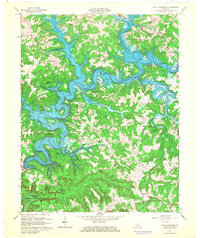 1966 Nolin Reservoir1968 Print · USGSEdmonson County landscape changed forever in the mid-1960s as the reservoir waters filled the deep valleys of the Nolin River. Genealogists and hikers can locate the Lincoln Sch, trace the Mammoth Cave National Park boundary near Ollie, and find the remote Demunbruns Store.3 unique versions available
 - 1967 Map of Leitchfield, 1968 Print
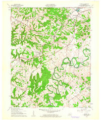
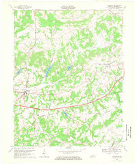
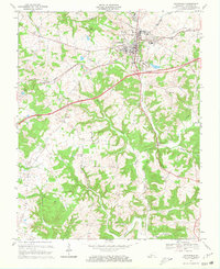 1967 Leitchfield1968 Print · USGSGrayson County's landscape undergoes a transformation in the late sixties as modern highways reach the outskirts of Leitchfield. Genealogists can trace family names at Kefauver Cem and William Cem, or locate rural landmarks like Black Rock and Liberty Ch.2 unique versions available
 - 1967 Map of Caneyville, 1969 Print
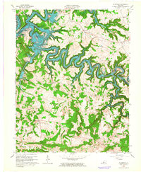
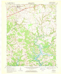
 1967 Caneyville1969 Print · USGSGrayson County in the late sixties shows a landscape where the new toll road and the established Illinois Central Railroad meet. Researchers can trace rural life through sites like New Hope Ch, Millwood, and the Caneyville Reservoir.
 - 1967 Map of Clarkson, 1969 Print
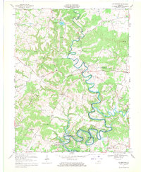
 1967 Clarkson1969 Print · USGSGrayson County's landscape is caught between its rail-era roots and modern highway expansion during the late sixties. Genealogists and local historians can trace family locations near Grayson Springs, Peonia, and St Augustines Ch or explore the newly flooded banks of the Nolin Reservoir.
 - 1967 Map of Millerstown, 1971 Print
 1967 Millerstown1971 Print · USGSKentucky's Nolin River valley is captured here in the late sixties as the new reservoir began to alter the local landscape. Researchers can trace ancestral locations across three counties, locating old landmarks like Riders Mill, Broad Ford Ch, and Mt Zion Cem.3 unique versions available
End of results
Showing maps 1-13 of 13
Top cities of Grayson County
Frequently asked questions
- What are the different types of historical maps available for Grayson County?
- What is the oldest map of Grayson County?
- Where can I purchase historical maps of Grayson County for my home or office?
- Where can I download high-res historical maps of Grayson County?
- Are there historical topographic maps available for Grayson County?
- Is there historical aerial imagery available for Grayson County?
- Where are historical maps of Grayson County sourced from?