Old Maps of Grayson County, Kentucky for Genealogy
Trace your family roots with 132 historic maps of Grayson County. These high-res maps reveal old neighborhoods, homesites, landmarks, and streets — helping you uncover where your ancestors lived and how the area evolved over time.
- Explore historic neighborhoods: Identify where your relatives may have lived in the 1800s or 1900s.
- Compare maps over time: Trace the changes in streets, buildings, and landmarks for multi-generational research.
- Perfect for genealogy & ancestry research: Used by family historians and researchers to map out lineage and migration.
These maps are an incredible resource for exploring your personal connection to Grayson County's past.
Grayson County, KY maps
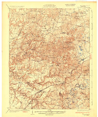
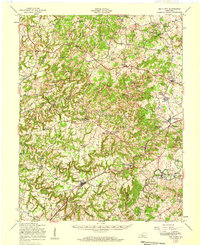
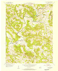
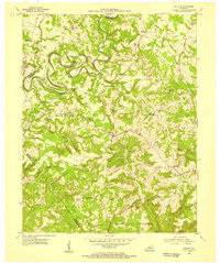
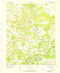
(132)- 1922 Map of Leitchfield
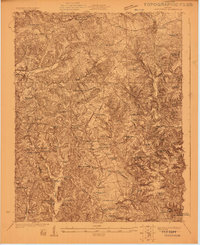 1922 Leitchfield1922 Print · USGSGrayson and Edmonson counties in the early twenties were defined by a robust network of small schools and local industry. Genealogists can trace family connections through landmarks like Duvall Cemetery, the Kentucky Rock Asphalt Co Mine, and the Rogers Springs School.
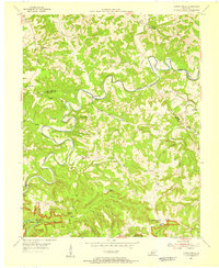
 - 1925 Map of Spring Lick
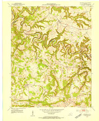
 1925 Spring Lick1925 Print · USGSButler and Ohio counties are shown here in the mid-1920s, featuring a landscape of rural schoolhouses and river bends. Genealogists can trace family connections through sites like Flener Chapel, Whiteoak School, and the Illinois Central rail stops.2 unique versions available
 - 1925 Map of Cub Run
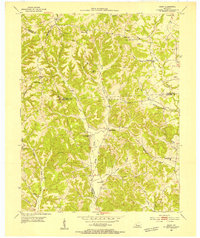
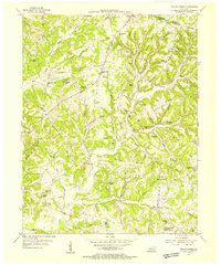
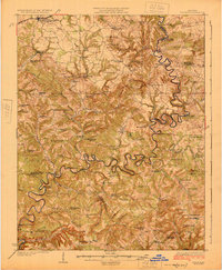 1925 Cub Run1925 Print · USGSCentral Kentucky's rural landscape is captured here in the mid-1920s, dominated by the intricate loops of the Nolin River. Genealogists and historians can locate numerous family-named landmarks like Dickeys Mills, Sanders Store, and Hester School.3 unique versions available
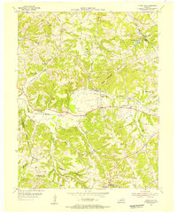
 - 1925 Map of Leitchfield
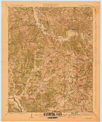
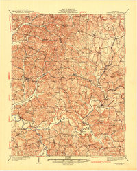
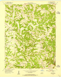
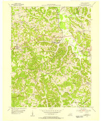
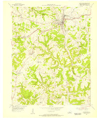
 1925 Leitchfield1925 Print · USGSGrayson and Edmonson counties are mapped in the mid-twenties as rural farming and coal communities. Genealogists can locate family landmarks like Rogers Springs School, the Meredith Coal Bank, and Beech Grove Church.2 unique versions available
 - 1932 Map of Big Clifty
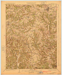
 1932 Big Clifty1932 Print · USGSGrayson and Hardin Counties are captured here between the World Wars, showing a rural landscape defined by the Illinois Central Railroad and the Dixie Highway. Genealogists and historians can locate dozens of small community centers like Big Clifty, White Mills, and the Asphalt Mine.5 unique versions available
 - 1932 Map of Fordsville
 1932 Fordsville1932 Print · USGSThe hill country of Ohio and Breckinridge Counties is captured here in the early thirties as the railroad age peaked. Researchers can trace family sites at Barretts Ferry PO Davidson Sta, Glen Dean, and the many schools like Fallen Rock Sch.
 - 1949 Map of Summit, 1952 Print
 1949 Summit1952 Print · USGSHardin and Grayson Counties are seen here in the late Forties, defined by the winding Nolin River and the rural railroad corridor. Genealogists and local historians can trace family-named sites like Horns Place, the Duncan Cem, and Webb Mills.
 - 1949 Map of Big Clifty, 1952 Print
 1949 Big Clifty1952 Print · USGSMid-century Grayson County comes to life in this detailed survey of the central Kentucky uplands during the postwar years. Local historians can trace the Illinois Central line through Big Clifty or locate ancestral sites like Smith Chapel and the Ford Sch.
 - 1949 Map of Big Clifty, 1959 Print
 1949 Big Clifty1959 Print · USGSThe rural communities of Grayson and Hardin counties are captured in the late 1940s, a time when small schoolhouses and country churches still anchored local life. Researchers can trace family roots at St Elizabeth Cem or locate long-standing landmarks like Pierce Mill and the Needham Chapel Ch along the Rough River.
 - 1953 Map of Mc Daniels, 1954 Print
 1953 Mc Daniels1954 Print · USGSBreckinridge and Grayson Counties are shown in the early fifties as the rural economy revolved around the winding Rough River. Researchers can trace the locations of family cemeteries like Poole Cem and vanished landmarks such as Johnson Sch and Stones Chapel Sch.
 - 1953 Map of Ready, 1954 Print
 1953 Ready1954 Print · USGSEdmonson and Grayson Counties are captured here in the early fifties, showing a rural landscape defined by close-knit crossroads communities. Researchers can trace the locations of family landmarks and local institutions like Rabbit Flat Ch, Sunfish Sch, and the Woosley Cem.3 unique versions available
 - 1953 Map of Bee Spring, 1955 Print
 1953 Bee Spring1955 Print · USGSEdmonson and Grayson Counties come alive in this mid-century survey of the rugged ridges above the Nolin River. Genealogists and local historians can trace family locations near Sweeden, identify historic burial sites like Gibson Cem, and locate long-gone schoolhouses such as Decker Sch and St Johns Sch.
 - 1953 Map of Falls Of Rough, 1955 Print
 1953 Falls Of Rough1955 Print · USGSThe Rough River valley in the early fifties shows a landscape of ridge-top schools and secluded family cemeteries. Researchers can trace ancestral locations at Yeaman or Tousey and find rural landmarks like Lone Hill Sch and Shady Grove Ch.
 - 1954 Map of Evansville
 1954 Evansville1954 Print · USGSThe Ohio River borderlands between Indiana and Kentucky appear here during a period of robust industrial and military growth. Genealogists and researchers can trace the rail corridors of the Illinois Central and find landmarks like US Lock and Dam No 48 or Camp Breckinridge.
 - 1954 Map of Dickeys Mills, 1955 Print
 1954 Dickeys Mills1955 Print · USGSThe Nolin River loops through the Kentucky karst country in the mid-fifties, just north of the legendary cave system. Trace family roots at Demunbruns Store, Temple Hill Ch, and cemeteries like Washington Meredith Cem.2 unique versions available
 - 1954 Map of Spring Lick, 1955 Print
 1954 Spring Lick1955 Print · USGSGrayson and Butler counties are captured here in the mid-fifties, showing a rural landscape of small rail-side settlements and ridge-top farms. Local historians can trace family roots through numerous country landmarks like Goffs (Steff P.O.), Do Stop, and Smalls Grove Ch.
 - 1954 Map of Welchs Creek, 1955 Print
 1954 Welchs Creek1955 Print · USGSButler County ridge country was a network of small schoolhouses and family-named cemeteries during the mid-fifties. Genealogists and hikers can trace old landmarks like Skullbone Rockhouse, the Lumbustown Cem, and Indian Camp Sch.2 unique versions available
 - 1954 Map of Clarkson, 1955 Print
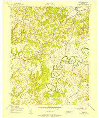
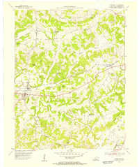
 1954 Clarkson1955 Print · USGSGrayson County's hilly heartland in the early fifties shows a landscape of small crossroads and parochial centers. Trace family sites and former schools like St Anthony Sch, the Illinois Central line, and communities from Peonia to Grayson Springs.
 - 1954 Map of Cub Run, 1955 Print
 1954 Cub Run1955 Print · USGSHart County and the surrounding Kentucky hills appear here in the mid-1950s, centered on the tight meanders of the Nolin River. Genealogists and local historians can trace rural family landmarks like Lines Mill, Broad Ford Sch, and Macedonia Ch.2 unique versions available
 - 1954 Map of Rosine, 1955 Print
 1954 Rosine1955 Print · USGSThe hill country of Ohio County in the mid-1950s is recorded here as the Illinois Central railroad connected rural hubs. Genealogists can trace family names at Boyd Cem or locate the old Leach Sch and settlements like Dogwalk.
 - 1954 Map of Caneyville, 1955 Print
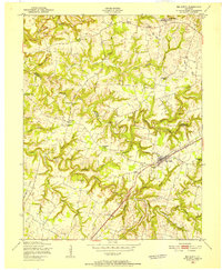
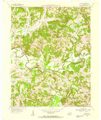
 1954 Caneyville1955 Print · USGSGrayson County in the mid-fifties is captured here during a time of bustling rural life and rail-side commerce. Researchers can trace the Illinois Central corridor or locate local landmarks like Ned Springs Sch and Macedonia Ch.
 - 1954 Map of Olaton, 1955 Print
 1954 Olaton1955 Print · USGSOhio County, Kentucky, in the mid-1950s is a landscape of creek-bottom farms and rural rail stops. You can trace the Illinois Central line to Davidson Sta or locate family sites like the Fallen Rock Sch and Huff Creek Ch.3 unique versions available
 - 1954 Map of Millerstown, 1955 Print
 1954 Millerstown1955 Print · USGSThe Nolin River meanders through the central Kentucky highlands during the mid-fifties, bordering Hardin and Grayson counties. Researchers can trace old river crossings at Broad Ford or locate rural landmarks like Wheelers Mill and Little Clifty Ch.
 - 1954 Map of Leitchfield, 1956 Print
 1954 Leitchfield1956 Print · USGSGrayson County's rural communities and the town of Leitchfield are captured here in the mid-1950s. Researchers can locate dozens of country schools and churches, from Burtle Grove Sch to Taylor Chapel Church, alongside the winding path of Bear Creek.
 - 1957 Map of Evansville, 1969 Print
 1957 Evansville1969 Print · USGSIndiana and Kentucky meet along the Ohio River in this mid-century survey of a vital industrial and transport corridor. Genealogists and historians can trace the development of river towns like Owensboro and Newburgh or locate old rail lines like the Southern Ry.3 unique versions available
Showing maps 1-25 of 132
Top cities of Grayson County
Frequently asked questions
- What are the different types of historical maps available for Grayson County?
- What is the oldest map of Grayson County?
- Where can I purchase historical maps of Grayson County for my home or office?
- Where can I download high-res historical maps of Grayson County?
- Are there historical topographic maps available for Grayson County?
- Is there historical aerial imagery available for Grayson County?
- Where are historical maps of Grayson County sourced from?