1950s Maps of Greenup County, Kentucky
Explore 17 historic maps of Greenup County from the 1950s. These maps offer a rare glimpse into what life looked like during the 1950s — showing old roads, neighborhoods, homes, and landmarks that have changed or disappeared over time.
Whether you're researching your family's past, planning a metal detecting trip, or studying how Greenup County's landscape evolved across the 1950s, these high-resolution maps are a powerful tool for exploring the history of this region.
- Focus on a specific era: All maps on this page are from the 1950s, giving you a focused view of this time period.
- See what’s changed: Compare century-old streets, trails, and buildings to today's modern landscape using overlays and satellite layers.
- Research with precision: Use these maps for genealogy, historical research, land use analysis, or educational projects.
- View, download, or print: Maps are fully viewable online in high resolution, and can be downloaded or printed for your own records.
Start exploring Greenup County's history through authentic maps from the 1950s. This is your window into the past.
Greenup County, KY maps
(17)- 1950 Map of Brushart
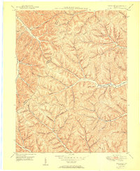 1950 Brushart1950 Print · USGSThe rural borderlands of Lewis and Greenup counties appear in the late 1940s as a landscape of isolated hollows and ridge-top crossings. Researchers can locate numerous local landmarks like Kenton-Furnace Sch, the Allen Cem, and the settlement of Whiteoak.
 - 1950 Map of Wesleyville, 1952 Print
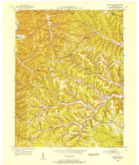 1950 Wesleyville1952 Print · USGSNortheastern Kentucky hill country at the start of the fifties reveals a landscape of isolated hollows and tightly-knit rural communities. Genealogists and hikers can trace old family burial grounds like Jordan Cem or locate the historic Wesleyville Post Office and Smith Creek Sch.
 - 1950 Map of Tygarts Valley, 1952 Print
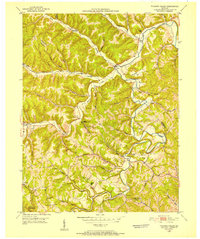 1950 Tygarts Valley1952 Print · USGSNortheastern Kentucky’s rugged iron-making and coal-mining history is preserved here just as the mid-century landscape was maturing. Researchers can trace rural family roots at Wolf P O, Lower Grassy Ch, and the historic Charlotte Furnace site.
 - 1951 Map of Garrison
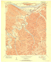 1951 Garrison1951 Print · USGSThe riverfront and rugged hollows of Lewis County are captured here just after the war, when the railroad still dominated the shoreline. Genealogists can locate family-named sites like Skidmore Cemetery and Tannery School along the winding Kinniconick Creek.
 - 1951 Map of Friendship
 1951 Friendship1951 Print · USGSThe Ohio River valley at the turn of the 1950s shows a landscape of river-dependent industry and hill-country settlements. Researchers can trace the legacy of family homesteads through features like Morris Hill Cem, Bethel Ch, and Upper Carey Run Sch.2 unique versions available
 - 1953 Map of Oldtown, 1954 Print
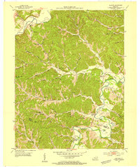 1953 Oldtown1954 Print · USGSSettled along the river and creek valleys of Greenup and Carter counties in the early fifties, this area shows a landscape of small farms and emerging energy extraction. Genealogists can locate family landmarks such as the Warnock Cem, Salem Ch, and several rural schoolhouses like Lost Creek Sch.3 unique versions available
 - 1953 Map of Rush, 1955 Print
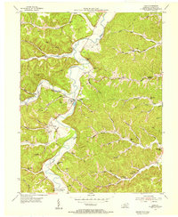
 1953 Rush1955 Print · USGSEastern Kentucky's coal and gas country comes into focus during the early fifties along the Chesapeake and Ohio line. Genealogists can locate family landmarks such as Gravel Lick Cemetery and Geigersville School among the active Strip Mines.2 unique versions available
 - 1953 Map of Load, 1955 Print
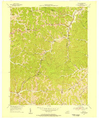
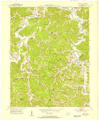
 1953 Load1955 Print · USGSGreenup County's rural creek valleys and upland ridges are captured here in the mid-1950s, showing a landscape shaped by coal and clay extraction. Researchers can trace the heritage of small communities through landmarks like the Old Raccoon Furnace, Nonchalanta Sch, and Load PO.2 unique versions available
 - 1953 Map of Ashland, 1955 Print
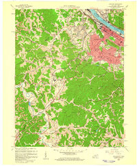
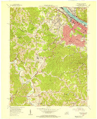 1953 Ashland1955 Print · USGSAshland was a thriving river and rail hub during the mid-fifties, dominated by its industrial waterfront and expanding hillside suburbs. Local researchers can trace family roots through the Rose Hill Burial Park, Summit settlement, and the grounds of the Federal Correctional Institution.
 - 1953 Map of Greenup, 1955 Print
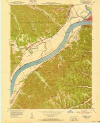
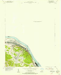
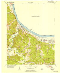 1953 Greenup1955 Print · USGSThe riverfront of Greenup County is captured here in the early fifties, showing the busy industrial corridor along the Ohio River. Researchers can trace old family burials at Cochran Cem, locate Biggs Sch, or follow the Chesapeake and Ohio rail line through Wurtland.
 - 1953 Map of Argillite, 1955 Print
 1953 Argillite1955 Print · USGSGreenup and Boyd County during the early fifties show a rural landscape transitioning between the old iron furnace era and modern coal mining. Genealogists can trace family landmarks like Reeves Cem and Howard Cem alongside numerous country schools such as Palmyra Sch and Montgomery Sch.
 - 1953 Map of Portsmouth, 1955 Print
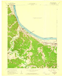
 1953 Portsmouth1955 Print · USGSThe industrial hub of the Ohio River valley is captured here in the early 1950s, showing the dense rail networks and river towns of Ohio and Kentucky. Researchers can trace family sites from Portsmouth to rural hill schools like Black Oak Sch and Valley View Sch.2 unique versions available
 - 1953 Map of Ironton, 1955 Print
 1953 Ironton1955 Print · USGSThe Ohio River bank was a hive of industrial and residential growth in the early fifties as the railroad and river trade intersected. Trace the development of communities like Flatwoods and Russell or locate family burial sites at Rude Cem and Baldridge Cem.
 - 1957 Map of Huntington, 1966 Print
 1957 Huntington1966 Print · USGSThe industrial heart of the Ohio River valley is captured here in the mid-sixties, showing the growth of Huntington and Ashland. Researchers can trace the extensive rail networks of the Chesapeake and Ohio RR and locate sites like the Chief Cornstalk Hunting Ground.3 unique versions available
 - 1958 Map of Ashland, 1959 Print
 1958 Ashland1959 Print · USGSAshland and the Ohio River valley are shown here during a mid-century period of heavy rail traffic and institutional growth. Researchers can locate the Federal Correctional Institution, numerous hillside Strip Mines, and local landmarks like Rose Hill Burial Park.
 - 1958 Map of Greenup, 1959 Print
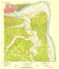
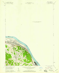
 1958 Greenup1959 Print · USGSGreenup County at the close of the 1950s shows a landscape of busy riverfront rail towns and deep interior hollows. Genealogists can locate family burial grounds like Heaberlin Cem or trace the early paths of the Chesapeake and Ohio and its impact on Wurtland and Riverton.
 - 1958 Map of Ironton, 1959 Print
 1958 Ironton1959 Print · USGSThe Ohio River valley was undergoing a mid-century industrial and residential shift in the late fifties. Genealogists and historians can trace family roots through sites like Indian Run Ch, the Bellefonte Memorial Cem, and Caroline Sch.
End of results
Showing maps 1-17 of 17
Top cities of Greenup County
- Flatwoods historical maps
- Russell historical maps
- Raceland historical maps
- Worthington historical maps
- Greenup historical maps
- Wurtland historical maps
See more
Frequently asked questions
- What are the different types of historical maps available for Greenup County?
- What is the oldest map of Greenup County?
- Where can I purchase historical maps of Greenup County for my home or office?
- Where can I download high-res historical maps of Greenup County?
- Are there historical topographic maps available for Greenup County?
- Is there historical aerial imagery available for Greenup County?
- Where are historical maps of Greenup County sourced from?