1900s (20th Century) Maps of Jackson County, Kentucky
Explore 23 historic maps of Jackson County from the 1900s (20th Century). These maps offer a rare glimpse into what life looked like during the 1900s — showing old roads, neighborhoods, homes, and landmarks that have changed or disappeared over time.
Whether you're researching your family's past, planning a metal detecting trip, or studying how Jackson County's landscape evolved across the 1900s, these high-resolution maps are a powerful tool for exploring the history of this region.
- Focus on a specific era: All maps on this page are from the 1900s, giving you a focused view of this time period.
- See what’s changed: Compare century-old streets, trails, and buildings to today's modern landscape using overlays and satellite layers.
- Research with precision: Use these maps for genealogy, historical research, land use analysis, or educational projects.
- View, download, or print: Maps are fully viewable online in high resolution, and can be downloaded or printed for your own records.
Start exploring Jackson County's history through authentic maps from the 1900s. This is your window into the past.
Jackson County, KY maps
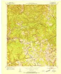
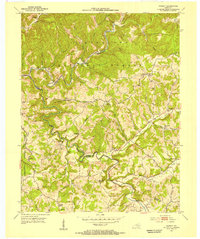
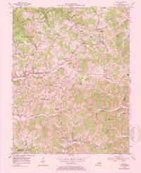
(23)- 1952 Map of Alcorn
 1952 Alcorn1952 Print · USGSThe valleys and hollows of eastern Kentucky appear here in the early fifties, showing a network of small settlements and family farms. Researchers can locate family roots at Hade Rose Cem or trace the early paths through Sinking Valley and Alcorn.3 unique versions available
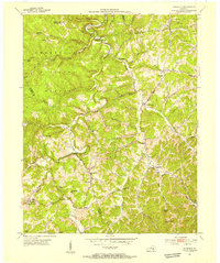
 - 1952 Map of Leighton
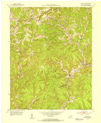
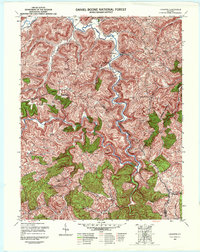 1952 Leighton1952 Print · USGSJackson and Estill counties are shown in the early fifties during a period of mountain isolation and quiet industrial change. Genealogists can locate remote family burial sites like Sommer Cem and early landmarks such as the Drip Rock Lookout Tower.4 unique versions available
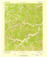
 - 1952 Map of Bighill, 1954 Print
 1952 Bighill1954 Print · USGSMadison and Jackson counties are captured in the early fifties, showing a rural landscape organized around deep hollows and high knobs. Local historians can trace family locations near New Liberty Ch, Hardin Cem, and vanished schools like Log Cabin Sch.4 unique versions available
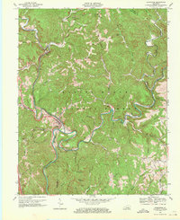
 - 1953 Map of Johnetta, 1954 Print
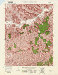
 1953 Johnetta1954 Print · USGSThe Rockcastle and Jackson County border comes alive in this early 1950s record of rural Kentucky life. Researchers can trace the footprints of community institutions like Owen Allen Sch, New Hope Ch, and the high vantage point of New Hope Lookout Tower.4 unique versions available
 - 1953 Map of Mc Kee, 1954 Print
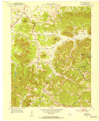
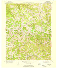
 1953 Mc Kee1954 Print · USGSJackson County life in the early fifties is etched into this survey of the Cumberland Plateau, where mountain hollows define the social landscape. Researchers can locate remote community hubs like Mc Kee, Gray Hawk, and the Pilgrims Rest Ch.3 unique versions available
 - 1953 Map of Sandgap, 1954 Print
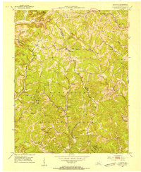
 1953 Sandgap1954 Print · USGSJackson County ridge-top life and deep forest hollows are captured here in the early fifties. Genealogists can trace family footprints through several local schoolhouses and country churches, including School No 1, Lettered Rock Ch, and the settlement at Waneta.3 unique versions available
 - 1953 Map of Livingston, 1954 Print
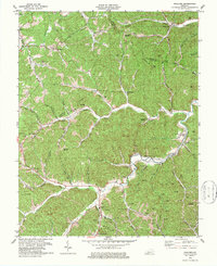
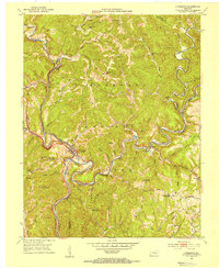 1953 Livingston1954 Print · USGSThe Rockcastle River valley and Cumberland National Forest appear here during the early fifties, showing a landscape shaped by the Louisville and Nashville railroad. Researchers can trace the historic Wilderness Road past Livingston and locate landmarks like the Camp Wildcat Battle Monument or the Sand Hill Lookout Tower.2 unique versions available
 - 1953 Map of Tyner, 1955 Print
 1953 Tyner1955 Print · USGSJackson County hill country is shown here in the early fifties as the regional road network around Tyner and Annville was maturing. Researchers can locate numerous rural landmarks like the Tyner High Sch, the Terrell Creek Tabernacle, and the Collier Sch.2 unique versions available
 - 1953 Map of Parrot, 1955 Print
 1953 Parrot1955 Print · USGSJackson and Laurel counties appear in the early fifties as a landscape of ridge-top settlements and isolated hollows within the Cumberland National Forest. Researchers can trace old family names and community centers like Parrot (Letter Box), Seven Pines, and the Carpenter Sch.3 unique versions available
 - 1953 Map of Sturgeon, 1955 Print
 1953 Sturgeon1955 Print · USGSOwsley and Lee counties in the early fifties reveal a landscape of mountain hollows and tight-knit ridge communities. Researchers can trace family sites near Travellers Rest, Green Hall, and the numerous local schoolhouses like Royal Oak Sch and Moores Sch.4 unique versions available
 - 1954 Map of Maulden, 1955 Print
 1954 Maulden1955 Print · USGSThe hills of Clay, Jackson, and Owsley Counties show a world of remote hollows and creek-side settlements during the mid-fifties. Genealogists can trace family names at Cradlebow Cem and locate community landmarks like Maulden PO and Silvermine Sch.2 unique versions available
 - 1957 Map of Winchester, 1968 Print
 1957 Winchester1968 Print · USGSCentral Kentucky's landscape in the mid-twentieth century features the sprawling Fort Knox and the early parkway system. Genealogists and historians can trace rail lines like the Southern Railway and find landmarks from Bernheim Forest to Pilot Knob.3 unique versions available
 - 1957 Map of Jenkins, 1974 Print
 1957 Jenkins1974 Print · USGSThe Cumberland Plateau in the mid-twentieth century reveals a complex landscape of winding river valleys and deep-seated industry. Genealogists and historians can trace the development of Hazard, Jenkins, and Pikeville alongside extensive Numerous Oil and Gas Fields and the routes of the Chesapeake & Ohio Railway.
 - 1960 Map of Jenkins
 1960 Jenkins1960 Print · USGSEastern Kentucky and the West Virginia borderlands are captured at a mid-century peak of the coal and rail era. Trace the industrial corridors of the Chesapeake and Ohio RR through mountain hubs like Hazard and Jenkins.
 - 1960 Map of Winchester
 1960 Winchester1960 Print · USGSCentral Kentucky's diverse landscape is shown here at mid-century, from the bluegrass plains to the rugged Pottsville Escarpment. Genealogists and historians can trace the rail-and-river network connecting towns like Bardstown and Stanford alongside landmarks like Lake Cumberland.
 - 1969 Map of Livingston, 1971 Print
 1969 Livingston1971 Print · USGSThe Rockcastle River corridor in the late sixties shows a landscape where historic transit routes and coal extraction meet. Local historians can trace the Wilderness Road and rail spurs near Livingston, or locate sites like Great Saltpetre Cave and Red Hill Sch.2 unique versions available
 - 1976 Map of Tyner, 1984 Print
 1976 Tyner1984 Print · USGSJackson County and the borders of Clay and Laurel Counties are captured here in the early 1950s. Genealogists can trace family roots through numerous remote burial sites like Walnut Hill Cem and old schoolhouses including Welchburg Sch.
 - 1977 Map of Hazard, 1983 Print
 1977 Hazard1983 Print · USGSEastern Kentucky's coal country comes into sharp focus during the late seventies, showing the deep-set river valleys and mountain gaps that shaped regional life. Genealogists can trace family connections through river-bottom settlements like Oneida, Krypton, and Bulan or follow the Seaboard System rail lines.
 - 1979 Map of Maulden
 1979 Maulden1979 Print · USGSClay County and the surrounding ridges are shown in the late seventies as the coal and gas industries reshaped the traditional landscape. Genealogists can locate family burial sites like McDaniel Cem and rural centers like Burning Springs and Little.
 - 1982 Map of Somerset, 1983 Print
 1982 Somerset1983 Print · USGSThe Lake Cumberland region and the Daniel Boone National Forest appear here in the early eighties. Researchers can trace rural lineages through Broughtontown, Science Hill, and Sinking Valley Church while exploring the rail lines of the Southern Railway.
 - 1982 Map of Irvine, 1983 Print
 1982 Irvine1983 Print · USGSEastern Kentucky's hill country is mapped here in the early eighties, showcasing the complex river valleys and ridge-top settlements of the Cumberland Plateau. Researchers can trace historic rail lines like the Louisville & Nashville RR or locate rural communities such as Beattyville and Slade.
 - 1986 Map of Harrodsburg
 1986 Harrodsburg1986 Print · USGSCentral Kentucky in the mid-eighties reveals a landscape defined by the winding Kentucky River and the bustling county seats of the Bluegrass. Genealogists and historians can trace the evolution of Harrodsburg, Danville, and Nicholasville alongside the Lexington Blue Grass Army Depot.
 - 1991 Map of Harrodsburg
 1991 Harrodsburg1991 Print · USGSThe heart of the Bluegrass region comes alive in the late twentieth century, showing the deep river gorges and limestone uplands of central Kentucky. Genealogists and local historians can locate Shakertown, the sprawling Lexington Blue Grass Army Depot, and Berea College.
End of results
Showing maps 1-23 of 23
Top cities of Jackson County
Frequently asked questions
- What are the different types of historical maps available for Jackson County?
- What is the oldest map of Jackson County?
- Where can I purchase historical maps of Jackson County for my home or office?
- Where can I download high-res historical maps of Jackson County?
- Are there historical topographic maps available for Jackson County?
- Is there historical aerial imagery available for Jackson County?
- Where are historical maps of Jackson County sourced from?