1900s (20th Century) Maps of McKee, Kentucky
Explore 8 historic maps of McKee from the 1900s (20th Century). These maps offer a rare glimpse into what life looked like during the 1900s — showing old roads, neighborhoods, homes, and landmarks that have changed or disappeared over time.
Whether you're researching your family's past, planning a metal detecting trip, or studying how McKee's landscape evolved across the 1900s, these high-resolution maps are a powerful tool for exploring the history of this region.
- Focus on a specific era: All maps on this page are from the 1900s, giving you a focused view of this time period.
- See what’s changed: Compare century-old streets, trails, and buildings to today's modern landscape using overlays and satellite layers.
- Research with precision: Use these maps for genealogy, historical research, land use analysis, or educational projects.
- View, download, or print: Maps are fully viewable online in high resolution, and can be downloaded or printed for your own records.
Start exploring McKee's history through authentic maps from the 1900s. This is your window into the past.
McKee, KY maps
(8)- 1953 Map of Mc Kee, 1954 Print
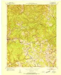 1953 Mc Kee1954 Print · USGSJackson County life in the early fifties is etched into this survey of the Cumberland Plateau, where mountain hollows define the social landscape. Researchers can locate remote community hubs like Mc Kee, Gray Hawk, and the Pilgrims Rest Ch.3 unique versions available
 - 1953 Map of Sandgap, 1954 Print
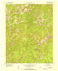 1953 Sandgap1954 Print · USGSJackson County ridge-top life and deep forest hollows are captured here in the early fifties. Genealogists can trace family footprints through several local schoolhouses and country churches, including School No 1, Lettered Rock Ch, and the settlement at Waneta.3 unique versions available
 - 1957 Map of Winchester, 1968 Print
 1957 Winchester1968 Print · USGSCentral Kentucky's landscape in the mid-twentieth century features the sprawling Fort Knox and the early parkway system. Genealogists and historians can trace rail lines like the Southern Railway and find landmarks from Bernheim Forest to Pilot Knob.3 unique versions available
 - 1957 Map of Jenkins, 1974 Print
 1957 Jenkins1974 Print · USGSThe Cumberland Plateau in the mid-twentieth century reveals a complex landscape of winding river valleys and deep-seated industry. Genealogists and historians can trace the development of Hazard, Jenkins, and Pikeville alongside extensive Numerous Oil and Gas Fields and the routes of the Chesapeake & Ohio Railway.
 - 1960 Map of Jenkins
 1960 Jenkins1960 Print · USGSEastern Kentucky and the West Virginia borderlands are captured at a mid-century peak of the coal and rail era. Trace the industrial corridors of the Chesapeake and Ohio RR through mountain hubs like Hazard and Jenkins.
 - 1960 Map of Winchester
 1960 Winchester1960 Print · USGSCentral Kentucky's diverse landscape is shown here at mid-century, from the bluegrass plains to the rugged Pottsville Escarpment. Genealogists and historians can trace the rail-and-river network connecting towns like Bardstown and Stanford alongside landmarks like Lake Cumberland.
 - 1977 Map of Hazard, 1983 Print
 1977 Hazard1983 Print · USGSEastern Kentucky's coal country comes into sharp focus during the late seventies, showing the deep-set river valleys and mountain gaps that shaped regional life. Genealogists can trace family connections through river-bottom settlements like Oneida, Krypton, and Bulan or follow the Seaboard System rail lines.
 - 1982 Map of Somerset, 1983 Print
 1982 Somerset1983 Print · USGSThe Lake Cumberland region and the Daniel Boone National Forest appear here in the early eighties. Researchers can trace rural lineages through Broughtontown, Science Hill, and Sinking Valley Church while exploring the rail lines of the Southern Railway.
End of results
Showing maps 1-8 of 8
Top cities near McKee
- Annville historical maps
- Island City historical maps
- Livingston historical maps
- Willow Shoals historical maps
Top neighborhoods of McKee
Frequently asked questions
- What are the different types of historical maps available for McKee?
- What is the oldest map of McKee?
- Where can I purchase historical maps of McKee for my home or office?
- Where can I download high-res historical maps of McKee?
- Are there historical topographic maps available for McKee?
- Is there historical aerial imagery available for McKee?
- Where are historical maps of McKee sourced from?