1990s Maps of Hollyvilla, Kentucky
Explore 2 historic maps of Hollyvilla from the 1990s. These maps offer a rare glimpse into what life looked like during the 1990s — showing old roads, neighborhoods, homes, and landmarks that have changed or disappeared over time.
Whether you're researching your family's past, planning a metal detecting trip, or studying how Hollyvilla's landscape evolved across the 1990s, these high-resolution maps are a powerful tool for exploring the history of this region.
- Focus on a specific era: All maps on this page are from the 1990s, giving you a focused view of this time period.
- See what’s changed: Compare century-old streets, trails, and buildings to today's modern landscape using overlays and satellite layers.
- Research with precision: Use these maps for genealogy, historical research, land use analysis, or educational projects.
- View, download, or print: Maps are fully viewable online in high resolution, and can be downloaded or printed for your own records.
Start exploring Hollyvilla's history through authentic maps from the 1990s. This is your window into the past.
Hollyvilla, KY maps
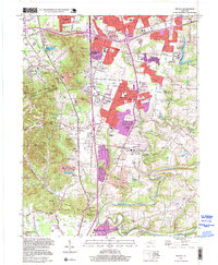
(2)- 1993 Map of Valley Station, 1996 Print
 1993 Valley Station1996 Print · USGSSouth of Louisville in the early nineties, the suburban growth of Valley Station meets the steep knobs of the Jefferson County Memorial Forest. Genealogists can locate numerous family burial sites like Bethany Mem Cem and Risinger Cem tucked among landmarks like Potato Knob.
 - 1997 Map of Brooks, 1999 Print
 1997 Brooks1999 Print · USGSThe Jefferson and Bullitt County line near the turn of the millennium shows a landscape of suburban growth and industrial heritage. Researchers can trace family history at Ball Cem and Quick Cem or explore the rail corridor near Hubers (Kenlite Sta).
End of results
Showing maps 1-2 of 2
Top cities near Hollyvilla
- Louisville historical maps
- Jeffersonville historical maps
- New Albany historical maps
- Jeffersontown historical maps
- Radcliff historical maps
- Clarksville historical maps
See more
Frequently asked questions
- What are the different types of historical maps available for Hollyvilla?
- What is the oldest map of Hollyvilla?
- Where can I purchase historical maps of Hollyvilla for my home or office?
- Where can I download high-res historical maps of Hollyvilla?
- Are there historical topographic maps available for Hollyvilla?
- Is there historical aerial imagery available for Hollyvilla?
- Where are historical maps of Hollyvilla sourced from?