
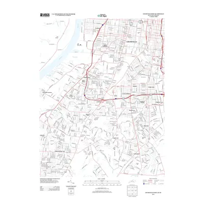
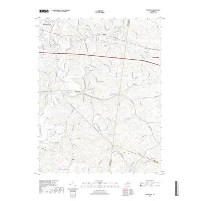
1993 Map of Valley Station
USGS Topo · Published 1996About this map
Valley Station and the suburban reaches of Prairie Village mark the transition from the Louisville metropolitan area into the steep, dissection-prone knobs of the south. The northern edge of the map is defined by residential expansion near Waverly Hills and industrial infrastructure like the Sewage Disposal plant and various substations. As the terrain rises into the Jefferson County Memorial Forest, the landscape shifts abruptly from organized street grids to winding ridge roads such as Mitchell Hill Road and Holsclaw Hill Road.
Find a feature on this map
82 named features on this map. Tap any name to fly to it.
Don’t see what you’re looking for? This feature index may not catch every label — zoom into the map to look around manually.
Map Details
Editions of this 1993 Valley Station Map
This is the sole edition of this map. No revisions or reprints were ever made.
Historical Maps of Louisville Through Time
48 maps found

1909 Kosmosdale
Jefferson County, KY

1912 Kosmosdale
Jefferson County, KY

1950 Kosmosdale
Jefferson County, KY

1951 Fisherville
Jefferson County, KY

1951 Louisville East
Jefferson County, KY

1951 Valley Station
Jefferson County, KY

1953 Madison East
Jefferson County, KY

1955 Louisville East
Jefferson County, KY

1955 Louisville West
Jefferson County, KY

1955 Valley Station
Jefferson County, KY

1960 Fisherville
Jefferson County, KY

1960 Louisville East
Jefferson County, KY

1960 Louisville West
Jefferson County, KY

1960 Valley Station
Jefferson County, KY

1965 Louisville East
Jefferson County, KY

1965 Louisville West
Jefferson County, KY

1981 Kosmosdale
Jefferson County, KY

1982 Fisherville
Jefferson County, KY

1982 Louisville East
Jefferson County, KY

1982 Valley Station
Jefferson County, KY

1983 Louisville West
Jefferson County, KY
1993 Valley Station
Jefferson County, KY

1998 Louisville West
Jefferson County, KY

2010 Fisherville
Jefferson County, KY

2010 Louisville East
Jefferson County, KY

2010 Louisville West
Jefferson County, KY

2010 Valley Station
Jefferson County, KY

2011 Kosmosdale
Jefferson County, KY

2013 Fisherville
Jefferson County, KY

2013 Kosmosdale
Jefferson County, KY

2013 Louisville East
Jefferson County, KY
2013 Louisville West
Jefferson County, KY

2013 Valley Station
Jefferson County, KY
2016 Fisherville
Jefferson County, KY

2016 Kosmosdale
Jefferson County, KY

2016 Louisville East
Jefferson County, KY
2016 Louisville West
Jefferson County, KY
2016 Valley Station
Jefferson County, KY
2019 Fisherville
Jefferson County, KY
2019 Kosmosdale
Jefferson County, KY
2019 Louisville East
Jefferson County, KY

2019 Louisville West
Jefferson County, KY
2019 Valley Station
Jefferson County, KY

2022 Fisherville
Jefferson County, KY

2022 Kosmosdale
Jefferson County, KY

2022 Louisville East
Jefferson County, KY

2022 Louisville West
Jefferson County, KY

2022 Valley Station
Jefferson County, KY