1950s Maps of Jessamine County, Kentucky
Explore 12 historic maps of Jessamine County from the 1950s. These maps offer a rare glimpse into what life looked like during the 1950s — showing old roads, neighborhoods, homes, and landmarks that have changed or disappeared over time.
Whether you're researching your family's past, planning a metal detecting trip, or studying how Jessamine County's landscape evolved across the 1950s, these high-resolution maps are a powerful tool for exploring the history of this region.
- Focus on a specific era: All maps on this page are from the 1950s, giving you a focused view of this time period.
- See what’s changed: Compare century-old streets, trails, and buildings to today's modern landscape using overlays and satellite layers.
- Research with precision: Use these maps for genealogy, historical research, land use analysis, or educational projects.
- View, download, or print: Maps are fully viewable online in high resolution, and can be downloaded or printed for your own records.
Start exploring Jessamine County's history through authentic maps from the 1950s. This is your window into the past.
Jessamine County, KY maps
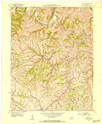
(12)- 1952 Map of Keene, 1953 Print
 1952 Keene1953 Print · USGSThe rolling Bluegrass region near the Jessamine and Woodford county lines is captured here in the early fifties. Genealogists and historians can trace the rural communities of Keene and Dixon Town, or locate landmarks like Ebenezer Cem and Clover Bottom Ch.3 unique versions available
 - 1952 Map of Valley View, 1953 Print
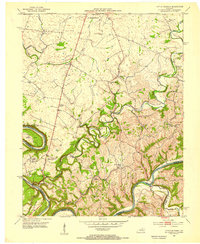
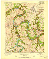
 1952 Valley View1953 Print · USGSThe Kentucky River meanders through the Madison and Jessamine county lines in the early fifties, anchored by the river landing at Valley View. Genealogists and local historians can trace rural schoolhouses like Newby Sch and several country churches, including Taylors Chapel and Antioch Ch.3 unique versions available
 - 1952 Map of Little Hickman, 1953 Print
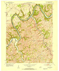
 1952 Little Hickman1953 Print · USGSJessamine County and the winding Kentucky River are captured here in the early fifties, documenting a landscape of tight-knit rural communities. Genealogists and historians can locate family landmarks like Roberts Chapel, Daniel Boones Cave, and the Camp Nelson National Cem.6 unique versions available
 - 1952 Map of Nicholasville, 1953 Print
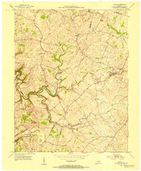
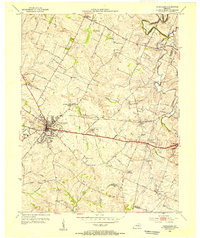
 1952 Nicholasville1953 Print · USGSThe Bluegrass heartland of Jessamine County comes alive in the early fifties, documenting a landscape of rural schools and rail-side settlements. Researchers can trace family roots through landmarks like Providence Ch, Lyons Sch, and the winding path of Hickman Creek.
 - 1952 Map of Buckeye, 1953 Print
 1952 Buckeye1953 Print · USGSGarrard County's high ridges and river bends are captured here in the early fifties, showing a rural landscape of crossroads hamlets and family farmsteads. Researchers can locate community centers like Teatersville and Bourne or trace rural churches such as Mt Hebron Ch.
 - 1952 Map of Coletown, 1953 Print
 1952 Coletown1953 Print · USGSFayette and Jessamine counties are captured here in the early fifties, showing a rural landscape defined by historic pikes and the winding Kentucky River. Researchers can trace old family sites and crossroads communities like Coletown, Jonestown, and the Eldridge Cem.
 - 1952 Map of Wilmore, 1953 Print
 1952 Wilmore1953 Print · USGSThe Jessamine County landscape near the Kentucky River is captured in the early fifties, showing the area's transition into the mid-century era. Genealogists and historians can locate established property patterns near Wilmore and the historic grounds of Shakertown.3 unique versions available
 - 1954 Map of Versailles, 1955 Print
 1954 Versailles1955 Print · USGSMid-century Versailles and Woodford County are captured here during a period of steady growth and local industrial activity. Researchers can trace family-named sites and vanished institutions like Hunter Town, Simmons High Sch, and the Phosphate Strip Mine.
 - 1956 Map of Louisville, 1971 Print
 1956 Louisville1971 Print · USGSThe Ohio River valley and the Kentucky Bluegrass are captured here during a period of rapid mid-century growth and industrial activity. Genealogists and historians can trace rail-centered towns and military land use at Fort Knox and the Jefferson Proving Ground.2 unique versions available
 - 1957 Map of Winchester, 1968 Print
 1957 Winchester1968 Print · USGSCentral Kentucky's landscape in the mid-twentieth century features the sprawling Fort Knox and the early parkway system. Genealogists and historians can trace rail lines like the Southern Railway and find landmarks from Bernheim Forest to Pilot Knob.3 unique versions available
 - 1959 Map of Coletown, 1960 Print
 1959 Coletown1960 Print · USGSFayette County at the close of the 1950s shows the growing city of Lexington expanding south toward the Kentucky River. Genealogists and local historians can locate several family landmarks and community centers including Walnut Hill Ch, Shelby Sch, and the Eldridge Cem.
 - 1959 Map of Nicholasville, 1960 Print
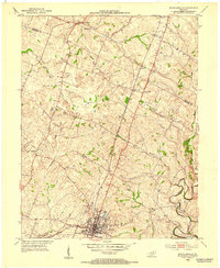
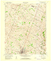 1959 Nicholasville1960 Print · USGSJessamine County's rolling farmland and the growing town of Nicholasville are captured here during the late fifties. Genealogists and local historians can trace the paths of Hickman Creek, locate the County High Sch, or find family sites near Union Mills.
End of results
Showing maps 1-12 of 12
Top cities of Jessamine County
Frequently asked questions
- What are the different types of historical maps available for Jessamine County?
- What is the oldest map of Jessamine County?
- Where can I purchase historical maps of Jessamine County for my home or office?
- Where can I download high-res historical maps of Jessamine County?
- Are there historical topographic maps available for Jessamine County?
- Is there historical aerial imagery available for Jessamine County?
- Where are historical maps of Jessamine County sourced from?