1990s Maps of Nealy, Kentucky
Explore 1 historic maps of Nealy from the 1990s. These maps offer a rare glimpse into what life looked like during the 1990s — showing old roads, neighborhoods, homes, and landmarks that have changed or disappeared over time.
Whether you're researching your family's past, planning a metal detecting trip, or studying how Nealy's landscape evolved across the 1990s, these high-resolution maps are a powerful tool for exploring the history of this region.
- Focus on a specific era: All maps on this page are from the 1990s, giving you a focused view of this time period.
- See what’s changed: Compare century-old streets, trails, and buildings to today's modern landscape using overlays and satellite layers.
- Research with precision: Use these maps for genealogy, historical research, land use analysis, or educational projects.
- View, download, or print: Maps are fully viewable online in high resolution, and can be downloaded or printed for your own records.
Start exploring Nealy's history through authentic maps from the 1990s. This is your window into the past.
Nealy, KY maps
(1)- 1992 Map of Kite
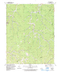 1992 Kite1992 Print · USGSKnott County's narrow hollers and coal-rich ridges are captured in the early nineties as they appeared before modern large-scale redevelopment. Genealogists and local historians can trace family locations near Pippa Passes, Topmost, and Providence Ch amidst an active landscape of Mines and oil wells.
End of results
Showing maps 1-1 of 1
Top cities near Nealy
- Jenkins historical maps
- Whitesburg historical maps
- Wheelwright historical maps
- Fleming-Neon historical maps
- Hindman historical maps
- Pippa Passes historical maps
See more
Frequently asked questions
- What are the different types of historical maps available for Nealy?
- What is the oldest map of Nealy?
- Where can I purchase historical maps of Nealy for my home or office?
- Where can I download high-res historical maps of Nealy?
- Are there historical topographic maps available for Nealy?
- Is there historical aerial imagery available for Nealy?
- Where are historical maps of Nealy sourced from?