1950s Maps of Louisa, Kentucky
Explore 5 historic maps of Louisa from the 1950s. These maps offer a rare glimpse into what life looked like during the 1950s — showing old roads, neighborhoods, homes, and landmarks that have changed or disappeared over time.
Whether you're researching your family's past, planning a metal detecting trip, or studying how Louisa's landscape evolved across the 1950s, these high-resolution maps are a powerful tool for exploring the history of this region.
- Focus on a specific era: All maps on this page are from the 1950s, giving you a focused view of this time period.
- See what’s changed: Compare century-old streets, trails, and buildings to today's modern landscape using overlays and satellite layers.
- Research with precision: Use these maps for genealogy, historical research, land use analysis, or educational projects.
- View, download, or print: Maps are fully viewable online in high resolution, and can be downloaded or printed for your own records.
Start exploring Louisa's history through authentic maps from the 1950s. This is your window into the past.
Louisa, KY maps
(5)- 1953 Map of Prichard, 1954 Print
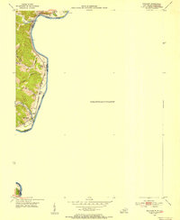 1953 Prichard1954 Print · USGSThe Big Sandy River corridor comes into focus in the early 1950s as a vital transportation link between Kentucky and West Virginia. Genealogists and rail historians can trace the paths of the Norfolk and Western railroad and locate local landmarks like Buchanan Chapel and Catalpa.2 unique versions available
 - 1953 Map of Louisa, 1955 Print
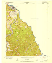 1953 Louisa1955 Print · USGSLawrence County at the mid-century shows a landscape shaped by the confluence of the Big Sandy River and the Tug Fork. Genealogists can trace family names through numerous burial sites and rural churches like Elizabeth Jarrell Ch, Chapman Ch, and the Preece Cem.
 - 1953 Map of Adams, 1955 Print
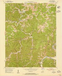 1953 Adams1955 Print · USGSLawrence County's coal and oil country comes into focus in the early fifties, showing a landscape shaped by narrow hollows and ridge-top settlements. Researchers can trace family locations near Evergreen, find rural landmarks like Blackburn Sch, and locate the Strip Mines along the Chesapeake and Ohio rail line.2 unique versions available
 - 1953 Map of Fallsburg, 1955 Print
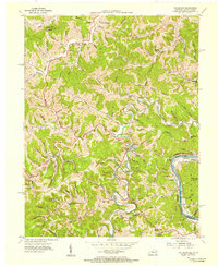 1953 Fallsburg1955 Print · USGSLawrence County, Kentucky, is shown in the early fifties as a landscape defined by its deep hollows and creek-side settlements. Genealogists can locate family landmarks like Garret Chapel, Dennis Sch, and the scattered communities of Yatesville and Five Forks.2 unique versions available
 - 1957 Map of Huntington, 1966 Print
 1957 Huntington1966 Print · USGSThe industrial heart of the Ohio River valley is captured here in the mid-sixties, showing the growth of Huntington and Ashland. Researchers can trace the extensive rail networks of the Chesapeake and Ohio RR and locate sites like the Chief Cornstalk Hunting Ground.3 unique versions available
End of results
Showing maps 1-5 of 5
Top cities near Louisa
Frequently asked questions
- What are the different types of historical maps available for Louisa?
- What is the oldest map of Louisa?
- Where can I purchase historical maps of Louisa for my home or office?
- Where can I download high-res historical maps of Louisa?
- Are there historical topographic maps available for Louisa?
- Is there historical aerial imagery available for Louisa?
- Where are historical maps of Louisa sourced from?