1900s (20th Century) Maps of Wilbur, Kentucky
Explore 8 historic maps of Wilbur from the 1900s (20th Century). These maps offer a rare glimpse into what life looked like during the 1900s — showing old roads, neighborhoods, homes, and landmarks that have changed or disappeared over time.
Whether you're researching your family's past, planning a metal detecting trip, or studying how Wilbur's landscape evolved across the 1900s, these high-resolution maps are a powerful tool for exploring the history of this region.
- Focus on a specific era: All maps on this page are from the 1900s, giving you a focused view of this time period.
- See what’s changed: Compare century-old streets, trails, and buildings to today's modern landscape using overlays and satellite layers.
- Research with precision: Use these maps for genealogy, historical research, land use analysis, or educational projects.
- View, download, or print: Maps are fully viewable online in high resolution, and can be downloaded or printed for your own records.
Start exploring Wilbur's history through authentic maps from the 1900s. This is your window into the past.
Wilbur, KY maps
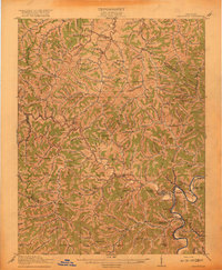
(8)- 1915 Map of Paintsville
 1915 Paintsville1915 Print · USGSEastern Kentucky during the first World War is captured here as the river-and-rail economy takes hold. Genealogists can trace family names through dozens of rural school districts and communities like Flatgap, Van Lear, and Staffordsville.
 - 1917 Map of Paintsville
 1917 Paintsville1917 Print · USGSEastern Kentucky during the first World War is meticulously documented here, showing the densely packed hollows of Johnson County. Genealogists can trace family roots through numerous numbered schools and rural settlements like Oil Springs, Flat Gap, and Hager Hill PO Johnson Sta.3 unique versions available
 - 1954 Map of Sitka, 1955 Print
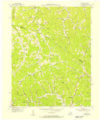 1954 Sitka1955 Print · USGSJohnson County’s hills and hollows are captured here during the mid-fifties, showing the rural way of life before modernization altered the landscape. Genealogists and historians can locate old post offices like Kerz and Sitka, plus numerous country schools including the Nancy Castle Memorial School.2 unique versions available
 - 1957 Map of Jenkins, 1974 Print
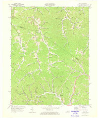
 1957 Jenkins1974 Print · USGSThe Cumberland Plateau in the mid-twentieth century reveals a complex landscape of winding river valleys and deep-seated industry. Genealogists and historians can trace the development of Hazard, Jenkins, and Pikeville alongside extensive Numerous Oil and Gas Fields and the routes of the Chesapeake & Ohio Railway.
 - 1960 Map of Jenkins
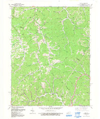
 1960 Jenkins1960 Print · USGSEastern Kentucky and the West Virginia borderlands are captured at a mid-century peak of the coal and rail era. Trace the industrial corridors of the Chesapeake and Ohio RR through mountain hubs like Hazard and Jenkins.
 - 1971 Map of Sitka, 1973 Print
 1971 Sitka1973 Print · USGSThe hollows of Johnson and Lawrence Counties were a hub of energy production in the early seventies. Genealogists and historians can trace family locations near Sitka, Stambaugh, and Davisville, or locate specific sites like Sugar Grove Ch and the Sparks Cem.2 unique versions available
 - 1982 Map of Williamson, 1983 Print
 1982 Williamson1983 Print · USGSThe Central Appalachian coalfields of West Virginia and Kentucky come into sharp focus here during the early eighties. Genealogists and researchers can trace the valley rail networks of the Norfolk and Western RR through Matewan, Williamson, and Blackberry City.
 - 1992 Map of Sitka
 1992 Sitka1992 Print · USGSThe borderlands of Johnson and Lawrence counties come into focus in the early nineties, revealing a landscape shaped by narrow valleys and energy extraction. Trace family roots at Pack and Chandler Cem, locate old Gas Wells, or find the former Lookout Tower near Winifred.
End of results
Showing maps 1-8 of 8
Top cities near Wilbur
- Paintsville historical maps
- Louisa historical maps
- Van Lear historical maps
- Fort Gay historical maps
- West Van Lear historical maps
- Blaine historical maps
Frequently asked questions
- What are the different types of historical maps available for Wilbur?
- What is the oldest map of Wilbur?
- Where can I purchase historical maps of Wilbur for my home or office?
- Where can I download high-res historical maps of Wilbur?
- Are there historical topographic maps available for Wilbur?
- Is there historical aerial imagery available for Wilbur?
- Where are historical maps of Wilbur sourced from?