1950s Maps of Whitesburg, Kentucky
Explore 3 historic maps of Whitesburg from the 1950s. These maps offer a rare glimpse into what life looked like during the 1950s — showing old roads, neighborhoods, homes, and landmarks that have changed or disappeared over time.
Whether you're researching your family's past, planning a metal detecting trip, or studying how Whitesburg's landscape evolved across the 1950s, these high-resolution maps are a powerful tool for exploring the history of this region.
- Focus on a specific era: All maps on this page are from the 1950s, giving you a focused view of this time period.
- See what’s changed: Compare century-old streets, trails, and buildings to today's modern landscape using overlays and satellite layers.
- Research with precision: Use these maps for genealogy, historical research, land use analysis, or educational projects.
- View, download, or print: Maps are fully viewable online in high resolution, and can be downloaded or printed for your own records.
Start exploring Whitesburg's history through authentic maps from the 1950s. This is your window into the past.
Whitesburg, KY maps
(3)- 1954 Map of Mayking, 1956 Print
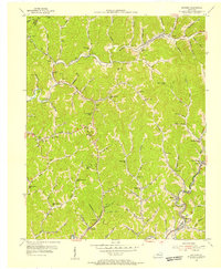 1954 Mayking1956 Print · USGSThe mountain hollows of Letcher County are captured here in the mid-1950s, a period when coal company data helped map these steep-walled valleys. Genealogists can trace family names through landmarks like Camp Branch Chapel, Upper Colly Sch, and Sergent.3 unique versions available
 - 1954 Map of Whitesburg, 1956 Print
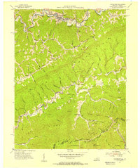 1954 Whitesburg1956 Print · USGSLetcher County at the mid-century mark shows a landscape of deep valleys and mountain ridges shaped by the coal and rail industries. Genealogists can trace family landmarks and rural institutions like Big Cowan Ch, Boggs Cem, and the Parsons Sch near the Virginia line.4 unique versions available
 - 1957 Map of Jenkins, 1974 Print
 1957 Jenkins1974 Print · USGSThe Cumberland Plateau in the mid-twentieth century reveals a complex landscape of winding river valleys and deep-seated industry. Genealogists and historians can trace the development of Hazard, Jenkins, and Pikeville alongside extensive Numerous Oil and Gas Fields and the routes of the Chesapeake & Ohio Railway.
End of results
Showing maps 1-3 of 3
Top cities near Whitesburg
- Norton historical maps
- Wise historical maps
- Cumberland historical maps
- Jenkins historical maps
- Appalachia historical maps
- Pound historical maps
See more
Frequently asked questions
- What are the different types of historical maps available for Whitesburg?
- What is the oldest map of Whitesburg?
- Where can I purchase historical maps of Whitesburg for my home or office?
- Where can I download high-res historical maps of Whitesburg?
- Are there historical topographic maps available for Whitesburg?
- Is there historical aerial imagery available for Whitesburg?
- Where are historical maps of Whitesburg sourced from?