1920s Maps of Grand Rivers, Kentucky
Explore 2 historic maps of Grand Rivers from the 1920s. These maps offer a rare glimpse into what life looked like during the 1920s — showing old roads, neighborhoods, homes, and landmarks that have changed or disappeared over time.
Whether you're researching your family's past, planning a metal detecting trip, or studying how Grand Rivers's landscape evolved across the 1920s, these high-resolution maps are a powerful tool for exploring the history of this region.
- Focus on a specific era: All maps on this page are from the 1920s, giving you a focused view of this time period.
- See what’s changed: Compare century-old streets, trails, and buildings to today's modern landscape using overlays and satellite layers.
- Research with precision: Use these maps for genealogy, historical research, land use analysis, or educational projects.
- View, download, or print: Maps are fully viewable online in high resolution, and can be downloaded or printed for your own records.
Start exploring Grand Rivers's history through authentic maps from the 1920s. This is your window into the past.
Grand Rivers, KY maps
(2)- 1928 Map of Eddyville
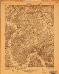 1928 Eddyville1928 Print · USGSWestern Kentucky's river valleys and mining districts are captured here in the late twenties before modern dams reshaped the Cumberland. Trace the old ferry crossings, family-run stops like Shelby's Store, and vanished school sites like Cherry Sch and Wilson Sch.
 - 1929 Map of Smithland
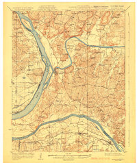 1929 Smithland1929 Print · USGSThe convergence of the Ohio, Tennessee, and Cumberland Rivers defines this late 1920s survey of the Kentucky-Illinois border. Genealogists and researchers can trace riverside life through Haddox Ferry, Smithland, and vanished schoolhouses like Yellowbird Sch.3 unique versions available
End of results
Showing maps 1-2 of 2
Top cities near Grand Rivers
- Benton historical maps
- Calvert City historical maps
- Eddyville historical maps
- Kuttawa historical maps
- Smithland historical maps
- Fredonia historical maps
Frequently asked questions
- What are the different types of historical maps available for Grand Rivers?
- What is the oldest map of Grand Rivers?
- Where can I purchase historical maps of Grand Rivers for my home or office?
- Where can I download high-res historical maps of Grand Rivers?
- Are there historical topographic maps available for Grand Rivers?
- Is there historical aerial imagery available for Grand Rivers?
- Where are historical maps of Grand Rivers sourced from?