Old Maps of Lyon County, Kentucky
Explore 92 old maps of Lyon County, spanning from 1908 to today. These high-resolution historic maps reveal how streets, neighborhoods, landmarks, and natural features evolved over time — perfect for genealogy, metal detecting, research, and local history exploration.
What you can do with these maps:
- See how Lyon County changed over time: Compare historical maps to modern-day views to trace roads, homesites, rail lines & more.
- View detailed metadata: Each map includes creators, publishers, year, scale, and archive source.
- Overlay maps with satellite & LiDAR: Visualize the past alongside modern tools to explore terrain & human change.
- Trusted historical sources: Maps sourced from the USGS, Library of Congress, and other archives.
- Access maps your way: View online, download high-res files, or order prints for personal or research use.
Start exploring old maps of Lyon County to uncover forgotten places, hidden landmarks, and the deep history beneath your feet.
Lyon County, KY maps
(92)- 1908 Map of Princeton, 1957 Print
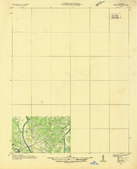
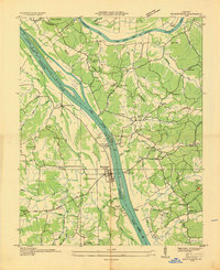
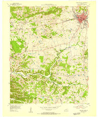
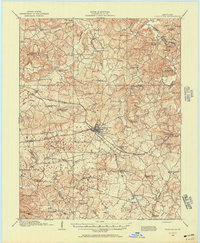 1908 Princeton1957 Print · USGSWestern Kentucky at the dawn of the twentieth century shows a landscape tied together by rail lines and rural schools. Genealogists can trace family footprints across dozens of local landmarks like Heathen Hill School, Otter Pond, and Briarfield Church.
 - 1910 Map of Princeton
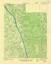
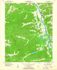
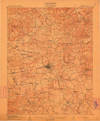 1910 Princeton1910 Print · USGSCaldwell County was a bustling rail hub at the turn of the century, centered on the strategic junction at Princeton. Genealogists can trace rural family roots through a dense network of country schools and churches like Heathen Hill School and Caldwell Chapel.5 unique versions available
 - 1928 Map of Eddyville
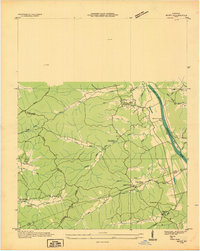
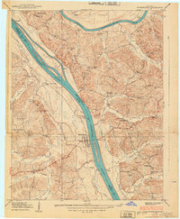
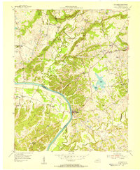
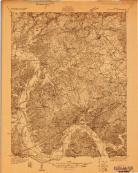 1928 Eddyville1928 Print · USGSWestern Kentucky's river valleys and mining districts are captured here in the late twenties before modern dams reshaped the Cumberland. Trace the old ferry crossings, family-run stops like Shelby's Store, and vanished school sites like Cherry Sch and Wilson Sch.
 - 1931 Map of Eddyville
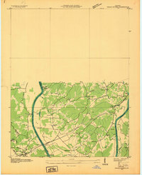
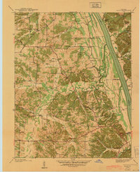
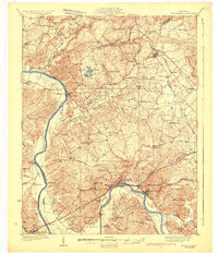 1931 Eddyville1931 Print · USGSWestern Kentucky life along the winding Cumberland River is captured here in the late twenties, before the landscape was altered by massive dam projects. Genealogists and historians can trace family roots through dozens of rural landmarks like Shelby's Store, the Nancy Hanks Mine, and Williams Chapel Sch.
 - 1936 Map of Eddyville
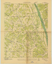
 1936 Eddyville1936 Print · USGSWestern Kentucky's river valleys appear here in the mid-1930s, showing the narrow land between the Tennessee and Cumberland rivers before the creation of major reservoirs. Genealogists can locate family landmarks like Sevenee Furnace Ch, Poplar Creek Sch, and the riverside Eureka Ferry.
 - 1936 Map of Mont
 1936 Mont1936 Print · USGSThe Tennessee and Cumberland river basins meet here in the 1930s, showing a landscape of rural post offices and iron-industry remnants. Genealogists can locate family landmarks like Hillman Store, Woods Chapel, and the Fulton Sch.
 - 1936 Map of Grand Rivers
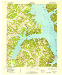
 1936 Grand Rivers1936 Print · USGSGrand Rivers sits at a strategic Kentucky crossroads in the mid-1930s, documenting the narrow land between two great river systems. Genealogists and local historians can trace the early layout of Grand Rivers and the Lyon and Livingston County line near the Cumberland River.
 - 1936 Map of Hiatt
 1936 Hiatt1936 Print · USGSThe Tennessee River corridor in the mid-1930s appears here before the formation of Kentucky Lake forever altered the local shoreline. Genealogists can locate family landmarks like Barnett Cem, rural centers like Faughns Store, and schools such as Collie Sch or Aurora Sch.
 - 1936 Map of Birmingham
 1936 Birmingham1936 Print · USGSThe Tennessee and Cumberland rivers converge in the mid-1930s, showing the riverfront town of Birmingham before the creation of Kentucky Lake. Genealogists and historians can trace numerous family burial sites like Birmingham Cem and rural centers such as Yale Sch and the Birmingham Ferry.
 - 1936 Map of Golden Pond
 1936 Golden Pond1936 Print · USGSWestern Kentucky’s river-locked interior is captured here in the mid-1930s, just before the creation of the great lakes. Local researchers can trace family roots at Birmingham or Fenton, and locate industrial landmarks like the Center Furnace and Star Lime Works.
 - 1938 Map of Birmingham
 1938 Birmingham1938 Print · USGSThe Tennessee and Cumberland Rivers converge in Lyon County just before the regional landscape was transformed by dam projects. Genealogists can trace family footprints at Birmingham, find rural landmarks like Star Lime Works PO, or locate Harvard Ch and Birmingham Cem.
 - 1940 Map of Hiatt
 1940 Hiatt1940 Print · USGSThe Tennessee River valley is shown just before the landscape was transformed by damming. Genealogists can trace family landmarks like Faughn Cem, Inmans Store, and riverfront sites at Ironton Landing.
 - 1949 Map of Paducah
 1949 Paducah1949 Print · USGSThe confluence of the Ohio, Mississippi, Tennessee, and Cumberland rivers at the close of the 1940s reveals a region bound by water and rail. Researchers can trace historic river landings, timberlands in the Shawnee National Forest, and the coal-mining infrastructure around West Frankfort and Herrin.2 unique versions available
 - 1950 Map of Paducah
 1950 Paducah1950 Print · USGSThe confluence of the great midwestern rivers defines this mid-century landscape at the intersection of Illinois, Kentucky, and Missouri. Genealogists and historians can trace the rail-and-river economy through the hubs of Paducah, Cairo, and Metropolis or locate family roots near the Wildcat Hills.
 - 1950 Map of Mont, 1953 Print
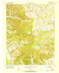
 1950 Mont1953 Print · USGSThe Between the Rivers country of Western Kentucky is documented here in the mid-twentieth century, just before its major federal transformation. Genealogists and historians can trace family sites like Woodson Chapel, Henderson Chapel Cem, and industrial remnants including the Center Furnace (Ruins).2 unique versions available
 - 1953 Map of Lamasco, 1954 Print
 1953 Lamasco1954 Print · USGSWestern Kentucky's rural landscape is captured here in the early fifties, just as the traditional river-and-road network remained largely intact. Researchers can trace family history through dozens of landmarks like Trigg Furnace Sch, Siloam Ch, and Parker Cem.2 unique versions available
 - 1954 Map of Evansville
 1954 Evansville1954 Print · USGSThe Ohio River borderlands between Indiana and Kentucky appear here during a period of robust industrial and military growth. Genealogists and researchers can trace the rail corridors of the Illinois Central and find landmarks like US Lock and Dam No 48 or Camp Breckinridge.
 - 1954 Map of Paducah
 1954 Paducah1954 Print · USGSSouthern Illinois and Western Kentucky intersect at the great river confluences during this mid-century era of rail and river industry. Genealogists and historians can trace family roots and commerce through river towns like Cairo, Metropolis, and Golconda, or along the tracks of the Illinois Central Railroad.2 unique versions available
 - 1954 Map of Eddyville, 1955 Print
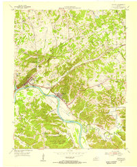 1954 Eddyville1955 Print · USGSWestern Kentucky river life is captured here in the mid-fifties, just before massive reservoir projects reshaped the valley. Researchers can trace the original riverfronts of Eddyville and Kuttawa, identifying landmarks like the State Penitentiary and the Illinois Central rail line.
 - 1954 Map of Fredonia, 1955 Print
 1954 Fredonia1955 Print · USGSMid-century Caldwell County centers on the fluorite mining hub of Fredonia as it appeared in the fifties. Genealogists and historians can locate family landmarks such as Campbell Cem, the community at Mexico, and local institutions like New Bethel Ch.2 unique versions available
 - 1954 Map of Princeton West, 1955 Print
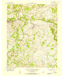
 1954 Princeton West1955 Print · USGSCaldwell County at the mid-century mark centers on the growing hub of Princeton and the busy ILLINOIS CENTRAL rail line. Researchers can trace rural lineages through numerous local landmarks like Friendship Ch, Dotson Sch, and Caldwell Cem.
 - 1954 Map of Dycusburg, 1955 Print
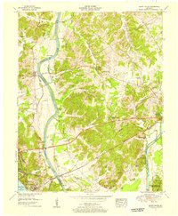
 1954 Dycusburg1955 Print · USGSThe Cumberland River loops through the western Kentucky fluorspar district during the mid-fifties, when small-scale mining shaped the local economy. Researchers can locate active operations like the Nancy Hanks Mine and rural landmarks such as Shelbys Store and Groves Chapel.2 unique versions available
 - 1955 Map of Fairdealing, 1956 Print
 1955 Fairdealing1956 Print · USGSMarshall County and the Tennessee River shoreline are captured here in the mid-fifties as the region adapted to the new reservoir. Genealogists and local historians can locate many family landmarks, such as Pleasant Hope Church, the Eggner Ferry Bridge, and Fairdealing.3 unique versions available
 - 1955 Map of Grand Rivers, 1956 Print
 1955 Grand Rivers1956 Print · USGSThe Land Between the Lakes region appears here in the mid-fifties, showing the intersection of river trade and modern reservoir development. Genealogists and historians can trace family landings such as Doom Landing, old churches like Suwanee Furnace Church, and the McPhail School.
 - 1955 Map of Birmingham Point, 1956 Print
 1955 Birmingham Point1956 Print · USGSBetween the Rivers in the mid-fifties, this area shows the dramatic transformation of the landscape following the creation of Kentucky Lake. Genealogists and local historians can locate family landmarks like the Birmingham Cem, Nickell Cem, and the Oakland Sch.2 unique versions available
Showing maps 1-25 of 92
Top cities of Lyon County
Frequently asked questions
- What are the different types of historical maps available for Lyon County?
- What is the oldest map of Lyon County?
- Where can I purchase historical maps of Lyon County for my home or office?
- Where can I download high-res historical maps of Lyon County?
- Are there historical topographic maps available for Lyon County?
- Is there historical aerial imagery available for Lyon County?
- Where are historical maps of Lyon County sourced from?