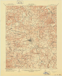
1908 Map of Princeton
USGS Topo · Published 1957About this map
Princeton serves as the central hub for several critical transit lines in the early twentieth century, with the Illinois Central and the Evansville and Hopkinsville Line converging at the town center. The surrounding landscape is characterized by a high density of rural schoolhouses and neighborhood churches, indicating a well-distributed agrarian population. From the Good Spring School in the northwest to the Bellbuckle School in the southeast, the map documents dozens of local community centers including the White Sulphur Church and Caldwell Chapel. Natural features like the Tradewater River and Eddy Creek define the drainage of this territory. The mapping of small settlements such as Crider, Dulaney, and Saratoga provides a detailed look at the rail-dependent economy and local social geography of Western Kentucky before the mid-century modernizations.
Find a feature on this map
61 named features on this map. Tap any name to fly to it.
Don’t see what you’re looking for? This feature index may not catch every label — zoom into the map to look around manually.
Map Details
Editions of this 1908 Princeton Map
This is the sole edition of this map. No revisions or reprints were ever made.