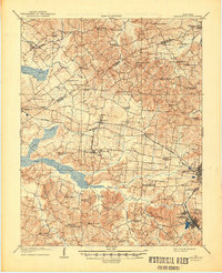
1907 Map of Earlington
USGS Topo · Published 1907About this map
Madisonville and Earlington anchor the coal-country landscape of Western Kentucky during a period of significant industrial and agricultural activity. The area is defined by a dense network of country schools and rural churches, including Ramsey School, Foxwell School, and the Mt Carmel Church, reflecting a closely-knit rural population. The Louisville and Nashville railroad cuts through the heart of the region, providing a critical artery for the transport of local resources alongside the Illinois Central tracks to the north.
Find a feature on this map
37 named features on this map. Tap any name to fly to it.
Don’t see what you’re looking for? This feature index may not catch every label — zoom into the map to look around manually.
Map Details
Editions of this 1907 Earlington Map
This is the sole edition of this map. No revisions or reprints were ever made.
Historical Maps of Madisonville Through Time
3 maps found