1900s (20th Century) Maps of Cambridge Shores, Kentucky
Explore 8 historic maps of Cambridge Shores from the 1900s (20th Century). These maps offer a rare glimpse into what life looked like during the 1900s — showing old roads, neighborhoods, homes, and landmarks that have changed or disappeared over time.
Whether you're researching your family's past, planning a metal detecting trip, or studying how Cambridge Shores's landscape evolved across the 1900s, these high-resolution maps are a powerful tool for exploring the history of this region.
- Focus on a specific era: All maps on this page are from the 1900s, giving you a focused view of this time period.
- See what’s changed: Compare century-old streets, trails, and buildings to today's modern landscape using overlays and satellite layers.
- Research with precision: Use these maps for genealogy, historical research, land use analysis, or educational projects.
- View, download, or print: Maps are fully viewable online in high resolution, and can be downloaded or printed for your own records.
Start exploring Cambridge Shores's history through authentic maps from the 1900s. This is your window into the past.
Cambridge Shores, KY maps
(8)- 1936 Map of Birmingham
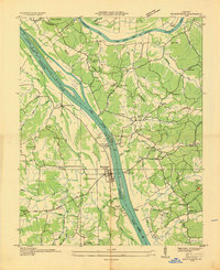 1936 Birmingham1936 Print · USGSThe Tennessee and Cumberland rivers converge in the mid-1930s, showing the riverfront town of Birmingham before the creation of Kentucky Lake. Genealogists and historians can trace numerous family burial sites like Birmingham Cem and rural centers such as Yale Sch and the Birmingham Ferry.
 - 1936 Map of Golden Pond
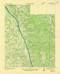 1936 Golden Pond1936 Print · USGSWestern Kentucky’s river-locked interior is captured here in the mid-1930s, just before the creation of the great lakes. Local researchers can trace family roots at Birmingham or Fenton, and locate industrial landmarks like the Center Furnace and Star Lime Works.
 - 1938 Map of Birmingham
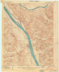 1938 Birmingham1938 Print · USGSThe Tennessee and Cumberland Rivers converge in Lyon County just before the regional landscape was transformed by dam projects. Genealogists can trace family footprints at Birmingham, find rural landmarks like Star Lime Works PO, or locate Harvard Ch and Birmingham Cem.
 - 1955 Map of Birmingham Point, 1956 Print
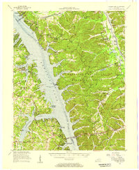
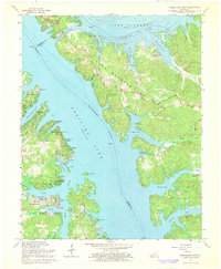
 1955 Birmingham Point1956 Print · USGSBetween the Rivers in the mid-fifties, this area shows the dramatic transformation of the landscape following the creation of Kentucky Lake. Genealogists and local historians can locate family landmarks like the Birmingham Cem, Nickell Cem, and the Oakland Sch.2 unique versions available
 - 1955 Map of Golden Pond, 1957 Print
 1955 Golden Pond1957 Print · USGSIn the mid-1950s, the peninsula between the Tennessee and Cumberland rivers was a landscape of deep hollows and new reservoirs. Trace family roots and local history through landmarks like Birmingham Cem, the ruins of Center Furnace, and Paradise Ch.
 - 1956 Map of Dyersburg, 1960 Print
 1956 Dyersburg1960 Print · USGSThe Four Rivers region comes alive in the mid-fifties, capturing the intricate borderlands of Tennessee, Kentucky, and Missouri. Genealogists and historians can trace the rail-and-river networks connecting Dyersburg, Caruthersville, and the shoreline of Reelfoot Lake.4 unique versions available
 - 1967 Map of Birmingham Point, 1968 Print
 1967 Birmingham Point1968 Print · USGSIn the late sixties, this area between the newly formed Kentucky Lake and Lake Barkley reveals a landscape transformed by water. Researchers can trace the original location of Birmingham, find family burial grounds like Demumbers Cem, and follow the route of The Trace.3 unique versions available
 - 1986 Map of Murray
 1986 Murray1986 Print · USGSWestern Kentucky in the mid-1980s reveals a landscape defined by the Tennessee and Cumberland rivers. Genealogists and historians can trace rail-town development along the Illinois Central Gulf RR and find family-named locations like Dukedom and Water Valley.2 unique versions available
End of results
Showing maps 1-8 of 8
Top cities near Cambridge Shores
- Benton historical maps
- Calvert City historical maps
- Eddyville historical maps
- Kuttawa historical maps
- Hardin historical maps
- Smithland historical maps
See more
Frequently asked questions
- What are the different types of historical maps available for Cambridge Shores?
- What is the oldest map of Cambridge Shores?
- Where can I purchase historical maps of Cambridge Shores for my home or office?
- Where can I download high-res historical maps of Cambridge Shores?
- Are there historical topographic maps available for Cambridge Shores?
- Is there historical aerial imagery available for Cambridge Shores?
- Where are historical maps of Cambridge Shores sourced from?