1990s Maps of Martin County, Kentucky
Explore 10 historic maps of Martin County from the 1990s. These maps offer a rare glimpse into what life looked like during the 1990s — showing old roads, neighborhoods, homes, and landmarks that have changed or disappeared over time.
Whether you're researching your family's past, planning a metal detecting trip, or studying how Martin County's landscape evolved across the 1990s, these high-resolution maps are a powerful tool for exploring the history of this region.
- Focus on a specific era: All maps on this page are from the 1990s, giving you a focused view of this time period.
- See what’s changed: Compare century-old streets, trails, and buildings to today's modern landscape using overlays and satellite layers.
- Research with precision: Use these maps for genealogy, historical research, land use analysis, or educational projects.
- View, download, or print: Maps are fully viewable online in high resolution, and can be downloaded or printed for your own records.
Start exploring Martin County's history through authentic maps from the 1990s. This is your window into the past.
Martin County, KY maps
(10)- 1992 Map of Milo
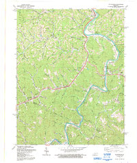
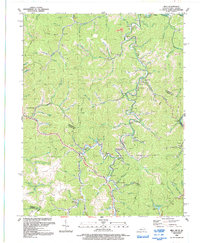 1992 Milo1992 Print · USGSMartin County and the winding Tug Fork are seen here in the early nineties, showing a landscape shaped by coal and gas. Genealogists can trace family names at Stidham, Peach Orchard, and New Friendship Ch.
 - 1992 Map of Kermit
 1992 Kermit1992 Print · USGSCoal and rail define this border region along the Tug Fork in the nineties. Researchers can trace the industrial footprint of the Strip Mine and Norfolk and Western railway alongside local landmarks like Warfield Sch and Gospel Light Ch.
 - 1992 Map of Offutt
 1992 Offutt1992 Print · USGSThe Levisa Fork valley in eastern Kentucky is shown here at the start of the 1990s, capturing a landscape of narrow hollows and industrial coal country. Genealogists can trace family landmarks and local community sites like the Ward Cem, Wells Chapel, and the historic mining hub of Van Lear.
 - 1992 Map of Lancer
 1992 Lancer1992 Print · USGSFloyd County during the early nineties shows a landscape defined by the winding waters of Dewey Lake and the active Levisa Fork river valley. Researchers can trace family sites at Mayo Cem and The Old Log Ch or locate old rail stops along the CSX Transportation line.
 - 1992 Map of Thomas
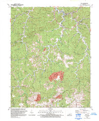
 1992 Thomas1992 Print · USGSThe rugged coal country of Eastern Kentucky is captured here during the early nineties, showing a landscape defined by hollows and heavy industry. Genealogists and local historians can locate rural landmarks such as Big Branch Ch, the settlement of McCombs, and the industrial infrastructure around Aldridge.
 - 1992 Map of Richardson
 1992 Richardson1992 Print · USGSEastern Kentucky's river valleys and coal-rich hills are documented here in the early 1990s, near the Lawrence and Johnson county line. Researchers can locate remote family cemeteries and rural landmarks like Borders Chapel, Lowmansville, and the riverside community of Richardson.
 - 1992 Map of Varney
 1992 Varney1992 Print · USGSEastern Kentucky's coal country and rural hollows are shown in the 1990s as mining and small mountain communities shaped the land. Researchers can trace family roots at Piso, Varney, and landmarks like Francis Cem or Apple Orchard Ch.
 - 1992 Map of Inez
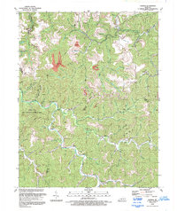
 1992 Inez1992 Print · USGSMartin County in the early 1990s shows a landscape of deep hollows where traditional mountain communities meet large-scale industrial mining. Genealogists can locate numerous family cemeteries and local landmarks like Davella Ch, Charity Chapel, and the community of Tomahawk.
 - 1992 Map of Williamson
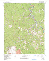
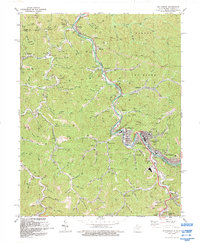 1992 Williamson1992 Print · USGSThe industrial heart of Mingo County is captured here in the early nineties, centered on the river-and-rail hub of Williamson. Genealogists and historians can trace the development of border towns like Nolan, Goodman, and Belfry along the Tug Fork.
 - 1997 Map of Naugatuck, 2003 Print
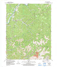
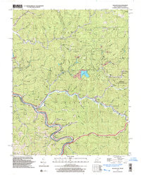 1997 Naugatuck2003 Print · USGSThe Tug River borderlands of Mingo County appear in detail here during the late nineties, showing the winding valleys of the West Virginia-Kentucky line. Researchers can trace family history through local sites like Parsley Bottom, Waldron Cem, and Mouth of Long Branch Sch.
End of results
Showing maps 1-10 of 10
Top cities of Martin County
Frequently asked questions
- What are the different types of historical maps available for Martin County?
- What is the oldest map of Martin County?
- Where can I purchase historical maps of Martin County for my home or office?
- Where can I download high-res historical maps of Martin County?
- Are there historical topographic maps available for Martin County?
- Is there historical aerial imagery available for Martin County?
- Where are historical maps of Martin County sourced from?