1940s Maps of Oakdale, Kentucky
Explore 2 historic maps of Oakdale from the 1940s. These maps offer a rare glimpse into what life looked like during the 1940s — showing old roads, neighborhoods, homes, and landmarks that have changed or disappeared over time.
Whether you're researching your family's past, planning a metal detecting trip, or studying how Oakdale's landscape evolved across the 1940s, these high-resolution maps are a powerful tool for exploring the history of this region.
- Focus on a specific era: All maps on this page are from the 1940s, giving you a focused view of this time period.
- See what’s changed: Compare century-old streets, trails, and buildings to today's modern landscape using overlays and satellite layers.
- Research with precision: Use these maps for genealogy, historical research, land use analysis, or educational projects.
- View, download, or print: Maps are fully viewable online in high resolution, and can be downloaded or printed for your own records.
Start exploring Oakdale's history through authentic maps from the 1940s. This is your window into the past.
Oakdale, KY maps
(2)- 1940 Map of Paducah, 1958 Print
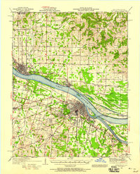 1940 Paducah1958 Print · USGSAcross the river from Illinois at the start of the 1940s, this area captures Paducah and Metropolis at a peak of rail and river activity. Researchers can trace the Illinois Central RR lines, locate family markers at Veyer Cemetery, and find rural landmarks like Klondike Sch and Palestine Ch.
 - 1949 Map of Paducah
 1949 Paducah1949 Print · USGSThe confluence of the Ohio, Mississippi, Tennessee, and Cumberland rivers at the close of the 1940s reveals a region bound by water and rail. Researchers can trace historic river landings, timberlands in the Shawnee National Forest, and the coal-mining infrastructure around West Frankfort and Herrin.2 unique versions available
End of results
Showing maps 1-2 of 2
Top cities near Oakdale
- Paducah historical maps
- Metropolis historical maps
- Reidland historical maps
- Benton historical maps
- Calvert City historical maps
- Brookport historical maps
See more
Frequently asked questions
- What are the different types of historical maps available for Oakdale?
- What is the oldest map of Oakdale?
- Where can I purchase historical maps of Oakdale for my home or office?
- Where can I download high-res historical maps of Oakdale?
- Are there historical topographic maps available for Oakdale?
- Is there historical aerial imagery available for Oakdale?
- Where are historical maps of Oakdale sourced from?