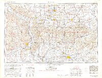
1940 Map of Paducah
USGS Topo · Published 1958About this map
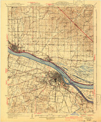
Paducah serves as the industrial and transit hub of this riverine landscape, where the confluence of the Ohio River, Tennessee River, and Clarks River creates a complex network of waterways and islands like Owens Island and Cuba Towhead. The era's transportation infrastructure is clearly defined by the Illinois Central RR and the Nashville Chattanooga and St Louis RR, which support the regional economy alongside the West Paducah PO. North of the river, the Illinois side features the town of Metropolis and the adjacent Massac State Park, while the rural hinterlands are densely marked with local institutions such as Palestine Ch, High Point Sch, and the County Sanitarium. The map documents a period of transition, with cultural details revised in 1940 using aerial photography to capture the growing footprint of settlements like Lone Oak, Reidland, and Woodlawn against the older farming landscape of Black Bottom.
Find a feature on this map
90 named features on this map. Tap any name to fly to it.
Don’t see what you’re looking for? This feature index may not catch every label — zoom into the map to look around manually.
Map Details
Editions of this 1940 Paducah Map
This is the sole edition of this map. No revisions or reprints were ever made.
Historical Maps of Paducah Through Time
12 maps found

1926 Paducah
McCracken County, KY
1929 Paducah
McCracken County, KY
1936 Paducah
McCracken County, KY
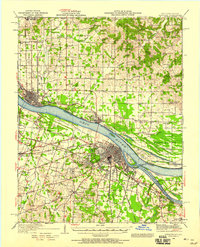
1940 Paducah
McCracken County, KY
1949 Paducah
McCracken County, KY

1950 Paducah
McCracken County, KY
1954 Paducah
McCracken County, KY
1961 Paducah
McCracken County, KY
1964 Paducah
McCracken County, KY

1984 Paducah
McCracken County, KY

1986 Paducah
McCracken County, KY

1987 Paducah
McCracken County, KY