Old Maps of Mercer County, Kentucky for Genealogy
Trace your family roots with 80 historic maps of Mercer County. These high-res maps reveal old neighborhoods, homesites, landmarks, and streets — helping you uncover where your ancestors lived and how the area evolved over time.
- Explore historic neighborhoods: Identify where your relatives may have lived in the 1800s or 1900s.
- Compare maps over time: Trace the changes in streets, buildings, and landmarks for multi-generational research.
- Perfect for genealogy & ancestry research: Used by family historians and researchers to map out lineage and migration.
These maps are an incredible resource for exploring your personal connection to Mercer County's past.
Mercer County, KY maps
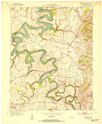
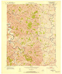
(80)- 1905 Map of Harrodsburg
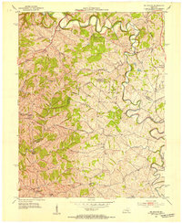
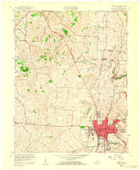
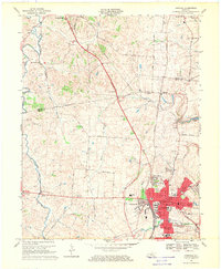
 1905 Harrodsburg1905 Print · USGSCentral Kentucky's Bluegrass region is captured here in the early twentieth century, showing a landscape defined by the deep gorges of the Kentucky River. Researchers can trace the era's vital rail networks and river commerce through features like Lock No 7 and the Louisville and Nashville RR.3 unique versions available
 - 1950 Map of Bryantsville, 1953 Print
 1950 Bryantsville1953 Print · USGSGarrard County and the winding Dix River are shown in the early fifties at the meeting of three counties. Local researchers can trace the Wilderness Trail and locate family landmarks like Robinson Reed Cem or the community of Bryantsville.
 - 1952 Map of Perryville, 1953 Print
 1952 Perryville1953 Print · USGSCentral Kentucky's rural landscape is captured here in the early 1950s, centered on the Chaplin River. Genealogists can trace family landmarks like Patterson Cem, Black Sch, and the grounds of Perryville Battlefield State Park.2 unique versions available
 - 1952 Map of Danville, 1953 Print
 1952 Danville1953 Print · USGSDanville and the surrounding Bluegrass countryside are shown in the early fifties as the region's institutional and transit hubs were firmly established. Genealogists can locate family landmarks like Salt River Cem, Faulkners Lane Ch, and small rail stops like Burgin.
 - 1952 Map of Harrodsburg, 1953 Print
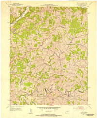
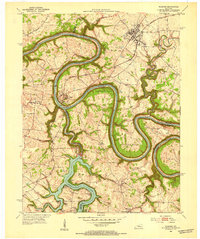
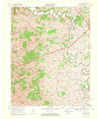
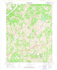
 1952 Harrodsburg1953 Print · USGSMercer County's historic core and the surrounding Bluegrass countryside are shown here in the early fifties. Local historians can trace family roots through landmarks like McAfee Sch and New Providence Cem, or explore the grounds of Fort Harrod.
 - 1952 Map of Cornishville, 1953 Print
 1952 Cornishville1953 Print · USGSMercer County's rural river valleys are captured here in the early fifties, showing the tightly wound meanders of the Chaplin River. Genealogists and local historians can trace family locations near Cornishville, Bohon, and Oakland Cem.2 unique versions available
 - 1952 Map of Ashbrook, 1953 Print
 1952 Ashbrook1953 Print · USGSAnderson County's rural heart is captured here in the early fifties, showing a landscape of high ridges and winding creek bottoms. Genealogists can trace family footprints at Ashbrook, Henrys Chapel, or Western Sch among the hills of Baxter Ridge.
 - 1952 Map of Bryantsville, 1953 Print
 1952 Bryantsville1953 Print · USGSGarrard County in the early fifties shows a landscape shaped by the winding Herrington Lake and the historic Wilderness Trail. Researchers can trace the layout of Bryantsville, the grounds of Camp Dick Robinson, and the State Hospital.3 unique versions available
 - 1952 Map of Salvisa, 1953 Print
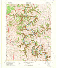
 1952 Salvisa1953 Print · USGSCentral Kentucky's river-cut uplands are mapped here in the early fifties, showing the deeply entrenched meanders of the Kentucky River. Local historians can trace family sites like Morris Cem and rural centers such as Salvisa, Mortonsville, and Hillsborough Ch.
 - 1952 Map of Mc Brayer, 1953 Print
 1952 Mc Brayer1953 Print · USGSThe Salt River valley in Mercer and Anderson counties comes into focus during the early fifties, showing a rural landscape of ridges and winding creeks. Genealogists can trace family sites like Bond-McCoy Cem or locate the community hubs of Mc Brayer and Goshen Ch.
 - 1952 Map of Wilmore, 1953 Print
 1952 Wilmore1953 Print · USGSThe Jessamine County landscape near the Kentucky River is captured in the early fifties, showing the area's transition into the mid-century era. Genealogists and historians can locate established property patterns near Wilmore and the historic grounds of Shakertown.3 unique versions available
 - 1953 Map of Mackville, 1954 Print
 1953 Mackville1954 Print · USGSCentral Kentucky's rural landscape is captured here in the early fifties, showing the farming communities at the junction of four counties. Genealogists can trace family names through landmarks like Cocanougher Cem, Pottsville, and Beech Grove Ch.2 unique versions available
 - 1953 Map of Cardwell, 1954 Print
 1953 Cardwell1954 Print · USGSCentral Kentucky's rural landscape is captured here in the early fifties, showing the winding Chaplin River at the border of Washington and Mercer Counties. Researchers can locate many family burial grounds and country crossroads like Tatham Springs, Mt Zion Ch, and the Pinkston Sch.2 unique versions available
 - 1957 Map of Winchester, 1968 Print
 1957 Winchester1968 Print · USGSCentral Kentucky's landscape in the mid-twentieth century features the sprawling Fort Knox and the early parkway system. Genealogists and historians can trace rail lines like the Southern Railway and find landmarks from Bernheim Forest to Pilot Knob.3 unique versions available
 - 1959 Map of Danville, 1960 Print
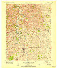
 1959 Danville1960 Print · USGSDanville and Harrodsburg anchor this late-fifties landscape as the region's rail and educational centers began to modernize. Genealogists and researchers can trace local heritage through landmarks like Centre College, the Mud Meetinghouse, and Pioneer Ch.
 - 1959 Map of Harrodsburg, 1960 Print
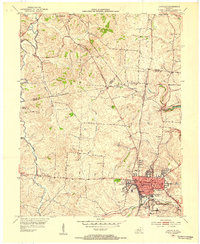
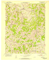
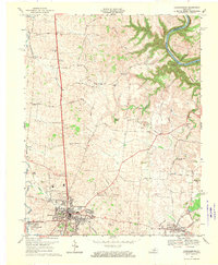
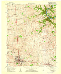 1959 Harrodsburg1960 Print · USGSMercer County at the end of the 1950s shows the growth of Harrodsburg and the surrounding rural settlements. Researchers can trace family sites near New Providence Ch, locate the old McAfee Sch, or find the Drive-in Theater as it stood mid-century.
 - 1960 Map of Winchester
 1960 Winchester1960 Print · USGSCentral Kentucky's diverse landscape is shown here at mid-century, from the bluegrass plains to the rugged Pottsville Escarpment. Genealogists and historians can trace the rail-and-river network connecting towns like Bardstown and Stanford alongside landmarks like Lake Cumberland.
 - 1967 Map of Mc Brayer, 1969 Print
 1967 Mc Brayer1969 Print · USGSAnderson and Mercer counties in the late sixties show a landscape in transition as modern parkways meet traditional river life. Genealogists and historians can trace family roots through rural landmarks like Dugansville, McBrayer, and several country churches like Kirkwood Ch.
 - 1967 Map of Salvisa, 1969 Print
 1967 Salvisa1969 Print · USGSThe Kentucky River meanders through the heart of bluegrass country in the late sixties, defining the borders of Mercer and Woodford counties. Genealogists can trace family names at Wilhoyt Cem and Morris Cem, or locate rural landmarks like Hillsborough Ch and the old Nonesuch Sch.2 unique versions available
 - 1967 Map of Danville, 1969 Print
 1967 Danville1969 Print · USGSDanville and its neighboring Mercer County communities are shown in the late sixties as the area transitioned into modern suburban growth. Genealogists can trace family landmarks like the Mud Meetinghouse, Salt River Cem, and Centre College.3 unique versions available
 - 1967 Map of Harrodsburg, 1970 Print
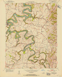
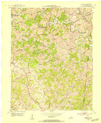
 1967 Harrodsburg1970 Print · USGSMercer County is captured here in the late sixties, centered on the growing town of Harrodsburg and the Kentucky River. Researchers can trace family homesteads near New Providence Ch, Burgin, and the river landing at Mundys Landing.3 unique versions available
 - 1972 Map of Ashbrook, 1973 Print
 1972 Ashbrook1973 Print · USGSAnderson and Washington counties are captured here in the early 1970s as the Blue Grass Parkway reshaped the rural landscape. Researchers can trace historic local hubs like Ashbrook, Sinai, and Johnsonville alongside old schools like Western Sch.3 unique versions available
 - 1981 Map of Elizabethtown, 1983 Print
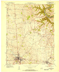
 1981 Elizabethtown1983 Print · USGSCentral Kentucky in the early eighties shows a landscape of military installations, state parks, and historic sites. Genealogists and historians can trace rail lines like the Louisville and Nashville or locate sites like Lebanon National Cemetery and the Lincoln Memorial National Historic Site.
 - 1986 Map of Harrodsburg
 1986 Harrodsburg1986 Print · USGSCentral Kentucky in the mid-eighties reveals a landscape defined by the winding Kentucky River and the bustling county seats of the Bluegrass. Genealogists and historians can trace the evolution of Harrodsburg, Danville, and Nicholasville alongside the Lexington Blue Grass Army Depot.
 - 1991 Map of Harrodsburg
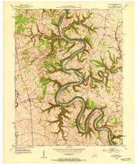
 1991 Harrodsburg1991 Print · USGSThe heart of the Bluegrass region comes alive in the late twentieth century, showing the deep river gorges and limestone uplands of central Kentucky. Genealogists and local historians can locate Shakertown, the sprawling Lexington Blue Grass Army Depot, and Berea College.
Showing maps 1-25 of 80
Top cities of Mercer County
Frequently asked questions
- What are the different types of historical maps available for Mercer County?
- What is the oldest map of Mercer County?
- Where can I purchase historical maps of Mercer County for my home or office?
- Where can I download high-res historical maps of Mercer County?
- Are there historical topographic maps available for Mercer County?
- Is there historical aerial imagery available for Mercer County?
- Where are historical maps of Mercer County sourced from?