1950s Maps of Harrodsburg, Kentucky
Explore 6 historic maps of Harrodsburg from the 1950s. These maps offer a rare glimpse into what life looked like during the 1950s — showing old roads, neighborhoods, homes, and landmarks that have changed or disappeared over time.
Whether you're researching your family's past, planning a metal detecting trip, or studying how Harrodsburg's landscape evolved across the 1950s, these high-resolution maps are a powerful tool for exploring the history of this region.
- Focus on a specific era: All maps on this page are from the 1950s, giving you a focused view of this time period.
- See what’s changed: Compare century-old streets, trails, and buildings to today's modern landscape using overlays and satellite layers.
- Research with precision: Use these maps for genealogy, historical research, land use analysis, or educational projects.
- View, download, or print: Maps are fully viewable online in high resolution, and can be downloaded or printed for your own records.
Start exploring Harrodsburg's history through authentic maps from the 1950s. This is your window into the past.
Harrodsburg, KY maps
(6)- 1952 Map of Danville, 1953 Print
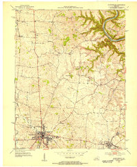
 1952 Danville1953 Print · USGSDanville and the surrounding Bluegrass countryside are shown in the early fifties as the region's institutional and transit hubs were firmly established. Genealogists can locate family landmarks like Salt River Cem, Faulkners Lane Ch, and small rail stops like Burgin.
 - 1952 Map of Harrodsburg, 1953 Print
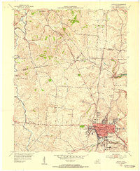
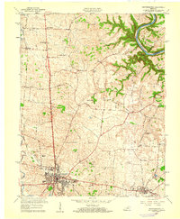
 1952 Harrodsburg1953 Print · USGSMercer County's historic core and the surrounding Bluegrass countryside are shown here in the early fifties. Local historians can trace family roots through landmarks like McAfee Sch and New Providence Cem, or explore the grounds of Fort Harrod.
 - 1952 Map of Cornishville, 1953 Print
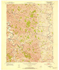 1952 Cornishville1953 Print · USGSMercer County's rural river valleys are captured here in the early fifties, showing the tightly wound meanders of the Chaplin River. Genealogists and local historians can trace family locations near Cornishville, Bohon, and Oakland Cem.2 unique versions available
 - 1957 Map of Winchester, 1968 Print
 1957 Winchester1968 Print · USGSCentral Kentucky's landscape in the mid-twentieth century features the sprawling Fort Knox and the early parkway system. Genealogists and historians can trace rail lines like the Southern Railway and find landmarks from Bernheim Forest to Pilot Knob.3 unique versions available
 - 1959 Map of Danville, 1960 Print
 1959 Danville1960 Print · USGSDanville and Harrodsburg anchor this late-fifties landscape as the region's rail and educational centers began to modernize. Genealogists and researchers can trace local heritage through landmarks like Centre College, the Mud Meetinghouse, and Pioneer Ch.
 - 1959 Map of Harrodsburg, 1960 Print
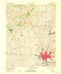
 1959 Harrodsburg1960 Print · USGSMercer County at the end of the 1950s shows the growth of Harrodsburg and the surrounding rural settlements. Researchers can trace family sites near New Providence Ch, locate the old McAfee Sch, or find the Drive-in Theater as it stood mid-century.
End of results
Showing maps 1-6 of 6
Top cities near Harrodsburg
- Lexington historical maps
- Nicholasville historical maps
- Danville historical maps
- Wilmore historical maps
- Stanford historical maps
- Junction City historical maps
See more
Frequently asked questions
- What are the different types of historical maps available for Harrodsburg?
- What is the oldest map of Harrodsburg?
- Where can I purchase historical maps of Harrodsburg for my home or office?
- Where can I download high-res historical maps of Harrodsburg?
- Are there historical topographic maps available for Harrodsburg?
- Is there historical aerial imagery available for Harrodsburg?
- Where are historical maps of Harrodsburg sourced from?