1900-1909 Maps of Ralph, Kentucky
Explore 2 historic maps of Ralph from 1900-1909. These maps offer a rare glimpse into what life looked like during the 1900s — showing old roads, neighborhoods, homes, and landmarks that have changed or disappeared over time.
Whether you're researching your family's past, planning a metal detecting trip, or studying how Ralph's landscape evolved across the 1900s, these high-resolution maps are a powerful tool for exploring the history of this region.
- Focus on a specific era: All maps on this page are from the 1900s, giving you a focused view of this time period.
- See what’s changed: Compare century-old streets, trails, and buildings to today's modern landscape using overlays and satellite layers.
- Research with precision: Use these maps for genealogy, historical research, land use analysis, or educational projects.
- View, download, or print: Maps are fully viewable online in high resolution, and can be downloaded or printed for your own records.
Start exploring Ralph's history through authentic maps from the 1900s. This is your window into the past.
Ralph, KY maps
(2)- 1907 Map of Whitesville, 1962 Print
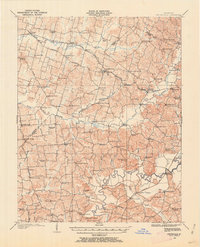 1907 Whitesville1962 Print · USGSDaviess and Ohio counties are captured here in the early 1900s, showcasing a rural landscape of crossroads settlements and river fords. Genealogists can locate specific family-named landmarks and community hubs like Hewlett's Store, Tanglewood School, and Little Zion Church.
 - 1909 Map of Whitesville
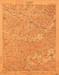 1909 Whitesville1909 Print · USGSKentucky's rural interior comes into focus here during the early 1900s, showing a landscape of small farming communities and river crossings. Genealogists can trace family roots through dozens of local landmarks like Whalen PO, St Thomas Church, and Berry School.2 unique versions available
End of results
Showing maps 1-2 of 2
Top cities near Ralph
- Owensboro historical maps
- Beaver Dam historical maps
- Hartford historical maps
- Cloverport historical maps
- Whitesville historical maps
- Fordsville historical maps
See more
Frequently asked questions
- What are the different types of historical maps available for Ralph?
- What is the oldest map of Ralph?
- Where can I purchase historical maps of Ralph for my home or office?
- Where can I download high-res historical maps of Ralph?
- Are there historical topographic maps available for Ralph?
- Is there historical aerial imagery available for Ralph?
- Where are historical maps of Ralph sourced from?