1940s Maps of Oldham Acres, Kentucky
Explore 1 historic maps of Oldham Acres from the 1940s. These maps offer a rare glimpse into what life looked like during the 1940s — showing old roads, neighborhoods, homes, and landmarks that have changed or disappeared over time.
Whether you're researching your family's past, planning a metal detecting trip, or studying how Oldham Acres's landscape evolved across the 1940s, these high-resolution maps are a powerful tool for exploring the history of this region.
- Focus on a specific era: All maps on this page are from the 1940s, giving you a focused view of this time period.
- See what’s changed: Compare century-old streets, trails, and buildings to today's modern landscape using overlays and satellite layers.
- Research with precision: Use these maps for genealogy, historical research, land use analysis, or educational projects.
- View, download, or print: Maps are fully viewable online in high resolution, and can be downloaded or printed for your own records.
Start exploring Oldham Acres's history through authentic maps from the 1940s. This is your window into the past.
Oldham Acres, KY maps
(1)- 1948 Map of Owen
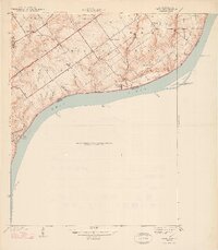 1948 Owen1948 Print · USGSThe Indiana shoreline of the Ohio River is captured here in the late thirties, just as the local landscape was beginning to shift for the war effort. Genealogists can locate family-named landmarks and institutions like Runyantown, Beech Grove Sch, and Rose Island Park.2 unique versions available
End of results
Showing maps 1-1 of 1
Top cities near Oldham Acres
- Louisville historical maps
- Jeffersonville historical maps
- New Albany historical maps
- Jeffersontown historical maps
- Clarksville historical maps
- Shively historical maps
See more
Frequently asked questions
- What are the different types of historical maps available for Oldham Acres?
- What is the oldest map of Oldham Acres?
- Where can I purchase historical maps of Oldham Acres for my home or office?
- Where can I download high-res historical maps of Oldham Acres?
- Are there historical topographic maps available for Oldham Acres?
- Is there historical aerial imagery available for Oldham Acres?
- Where are historical maps of Oldham Acres sourced from?