Old Maps of Owen County, Kentucky
Explore 98 old maps of Owen County, spanning from 1906 to today. These high-resolution historic maps reveal how streets, neighborhoods, landmarks, and natural features evolved over time — perfect for genealogy, metal detecting, research, and local history exploration.
What you can do with these maps:
- See how Owen County changed over time: Compare historical maps to modern-day views to trace roads, homesites, rail lines & more.
- View detailed metadata: Each map includes creators, publishers, year, scale, and archive source.
- Overlay maps with satellite & LiDAR: Visualize the past alongside modern tools to explore terrain & human change.
- Trusted historical sources: Maps sourced from the USGS, Library of Congress, and other archives.
- Access maps your way: View online, download high-res files, or order prints for personal or research use.
Start exploring old maps of Owen County to uncover forgotten places, hidden landmarks, and the deep history beneath your feet.
Owen County, KY maps
(98)- 1906 Map of Lockport
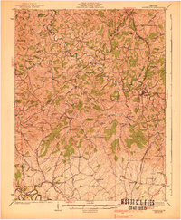
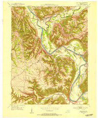
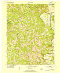
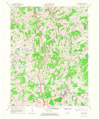
 1906 Lockport1906 Print · USGSOwen and Franklin Counties are surveyed here during the first decade of the century, following the dramatic bends of the Kentucky River. Researchers can trace the river-based economy through Lock & Dam No 1 and old crossings like Manfords Ferry.2 unique versions available
 - 1908 Map of Lockport
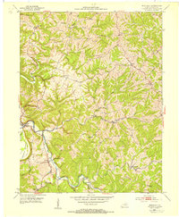
 1908 Lockport1908 Print · USGSLife along the Kentucky River in the early twentieth century centered on the water and the rich flats of the river bottoms. Genealogists can trace family footprints through numerous river crossings like Harpers Ferry and rural landmarks such as Tackitts Mill or the Falling Rock School.3 unique versions available
 - 1939 Map of Sadieville
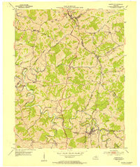
 1939 Sadieville1939 Print · USGSScott and Owen Counties are captured in the late 1930s as agricultural life centered on the Southern Railway and a dense network of country schools. Genealogists can locate family landmarks like Stamping Ground, Burroak Sch, and the Pleasant Hill Ch.2 unique versions available
 - 1943 Map of Vevay South
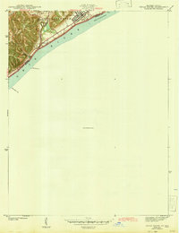 1943 Vevay South1943 Print · USGSThe Indiana side of the Ohio River is captured in the early 1940s, showing the riverside town of Vevay and its surrounding hills. Genealogists can trace family landmarks like Potato Bug Hill, the Bridge Sch, and the County Infirmary.
 - 1950 Map of New Liberty, 1952 Print
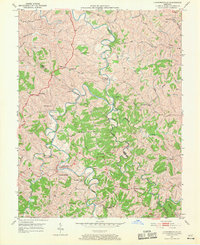
 1950 New Liberty1952 Print · USGSOwen County at mid-century shows a landscape of deep creek valleys and high ridges anchored by the Kentucky River. Genealogists can locate numerous family and lodge landmarks, including the I O O F Cem, White Chapel Sch, and Squiresville.4 unique versions available
 - 1950 Map of Glencoe, 1952 Print
 1950 Glencoe1952 Print · USGSThe rural borders of Gallatin, Owen, and Grant Counties come alive in the early fifties, centered on the railroad hub of Glencoe. Genealogists can trace family roots through numerous local sites like the I O O F Cem, Slab Lick Sch, and Pleasant Home Ch.2 unique versions available
 - 1950 Map of Owenton, 1952 Print
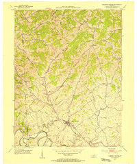
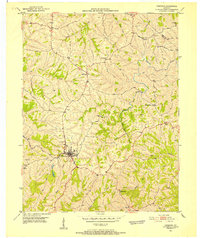 1950 Owenton1952 Print · USGSMid-century Owen County is a landscape of ridge-top settlements and deep creek valleys during the height of its rural post-war era. Genealogists can trace family lines through numerous landmarks like the Duvall and Steger Cem, Sweet Owen, and Mt Carmel Ch.4 unique versions available
 - 1950 Map of Lawrenceville, 1970 Print
 1950 Lawrenceville1970 Print · USGSThe Grant and Owen County line follows the deep meanders of the river in the 1950s. Genealogists can trace family landmarks and rural life at Lusbys Mill, the Lingenfelter Cemetery, and small country congregations like Musselshoals Church.
 - 1951 Map of Sanders, 1953 Print
 1951 Sanders1953 Print · USGSNorthern Kentucky in the early fifties was defined by the steam and steel of the Louisville and Nashville railroad as it wound through the Eagle Creek valley. Genealogists can locate family landmarks like Furnish Cem, Drury Chapel, and the remote Park Ridge Sch.
 - 1952 Map of Vevay South, 1954 Print
 1952 Vevay South1954 Print · USGSThe Ohio River valley at the Indiana-Kentucky border was a landscape of riverfront hubs and isolated hill settlements in the early fifties. Genealogists and historians can trace family plots at O'Neal Cem or Stafford Cem and locate rural landmarks like Marvin Chapel and the Easterday settlement.2 unique versions available
 - 1952 Map of Worthville, 1954 Print
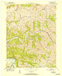
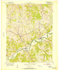
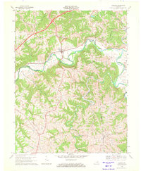
 1952 Worthville1954 Print · USGSThe Kentucky River valley in the early 1950s shows a landscape of sharp ridges and deep creek bottoms at the junction of three counties. Genealogists can locate family-named landmarks like Emily Run and Gullion Run or the riverside community of Worthville.3 unique versions available
 - 1953 Map of Monterey, 1954 Print
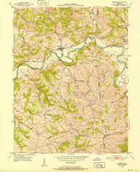
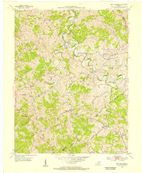
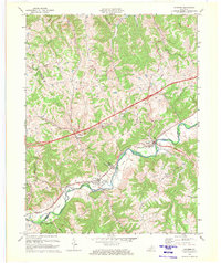
 1953 Monterey1954 Print · USGSIn the early 1950s, this Owen County region was a landscape of ridge-top settlements and creek-side congregations. Genealogists and local historians can trace the foundations of Monterey and locate family landmarks like Webster Cem or Greenup Fork Ch.3 unique versions available
 - 1953 Map of Gratz, 1954 Print
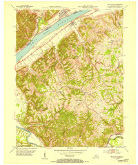
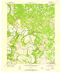
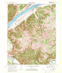
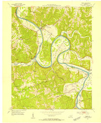 1953 Gratz1954 Print · USGSThe Kentucky River valley at the Henry and Owen county line is captured here in the early fifties, showcasing a river-centric way of life. Genealogists and local historians can locate Lock No 2, the Cemetery Hill Ch, and the town of Gratz as they appeared mid-century.3 unique versions available
 - 1953 Map of Sadieville, 1954 Print
 1953 Sadieville1954 Print · USGSNorthern Scott County during the early 1950s was a landscape of deep creek valleys and ridgeline roads centered on the Southern rail line. Researchers can locate family landmarks such as Odd Fellows Cem and rural centers like Stonewall or Hinton.
 - 1953 Map of Polsgrove, 1955 Print
 1953 Polsgrove1955 Print · USGSNorthern Kentucky's river valleys and ridge-top settlements are meticulously detailed in this early 1950s survey. Researchers can trace family roots at Harpers Ferry, locate the Bald Knob High Sch, and find local landmarks like Ottusville or Mt Carmel Ch.4 unique versions available
 - 1953 Map of Stamping Ground, 1955 Print
 1953 Stamping Ground1955 Print · USGSThe rural landscape of Scott and Owen counties in the early fifties is defined by small crossroads hamlets and the path of the Frankfort and Cincinnati railroad. Genealogists can trace family footprints through several local burial sites including Minorsville Cem, Riddle Cem, and Cedar Grove Cem.3 unique versions available
 - 1953 Map of New Columbus, 1955 Print
 1953 New Columbus1955 Print · USGSOwen County in the early fifties is mapped here in detail, showing a landscape defined by the winding Eagle Creek and rural hamlets. Researchers can trace family history through numerous remote sites like Hudson Abbot Cem, New Columbus, and Caney Creek Ch.3 unique versions available
 - 1954 Map of Switzer, 1955 Print
 1954 Switzer1955 Print · USGSThe river valleys of Franklin and Owen Counties appear in detail during the mid-fifties as the landscape transitions from the Kentucky River to Elkhorn Creek. Researchers can trace rural community centers like Peaks Mill and Elmville, or locate family landmarks such as Tacketts Mill and Carr Cem.4 unique versions available
 - 1956 Map of Louisville, 1971 Print
 1956 Louisville1971 Print · USGSThe Ohio River valley and the Kentucky Bluegrass are captured here during a period of rapid mid-century growth and industrial activity. Genealogists and historians can trace rail-centered towns and military land use at Fort Knox and the Jefferson Proving Ground.2 unique versions available
 - 1964 Map of Louisville
 1964 Louisville1964 Print · USGSThe Ohio River valley and Kentucky Bluegrass are captured in the mid-1960s, showing a region balanced between industrial growth and its agrarian roots. Genealogists and historians can trace the development of county seats like Shelbyville and Paris, or locate established institutions such as Georgetown College and Bernheim Forest.
 - 1965 Map of Sadieville, 1966 Print
 1965 Sadieville1966 Print · USGSNorth Central Kentucky sits at a crossroads in the mid-sixties as the newly built Interstate 75 carves through the rural landscape. Researchers can trace historic family sites and early infrastructure including the Southern Railway, Zion Hill Ch, and Sadieville.2 unique versions available
 - 1967 Map of Vevay South, 1969 Print
 1967 Vevay South1969 Print · USGSThe Ohio River borderlands between Kentucky and Indiana are captured here in the late sixties, showcasing a landscape of riverside industry and steep ridges. Genealogists can trace family names and landmarks from the riverfronts of Vevay and Ghent to inland sites like Sharon Ch and Eagle Station.3 unique versions available
 - 1969 Map of Glencoe, 1971 Print
 1969 Glencoe1971 Print · USGSThe Eagle Creek valley in the late sixties shows a landscape of deep meanders and rural Kentucky settlements along the Gallatin and Owen county lines. Genealogists and local historians can trace family-named landmarks like Oakland Ch, the small town of Glencoe, and the Louisville and Nashville rail corridor.
 - 1969 Map of Sanders, 1972 Print
 1969 Sanders1972 Print · USGSNorthern Kentucky at the end of the sixties is defined here by the winding Eagle Creek valley and the Louisville and Nashville railroad. Genealogists can trace family names and sites around Sanders, Sparta, and Bramlette Ch.2 unique versions available
 - 1986 Map of Lexington
 1986 Lexington1986 Print · USGSCentral Kentucky’s Bluegrass region is captured in the mid-eighties as urban centers like Lexington and Frankfort expand alongside deep-rooted rural hubs. Researchers can trace historic rail lines like the Southern Railway and find landmarks such as the Lexington Blue Grass Army Depot and Tacketts Mill.
Showing maps 1-25 of 98
Top cities of Owen County
Frequently asked questions
- What are the different types of historical maps available for Owen County?
- What is the oldest map of Owen County?
- Where can I purchase historical maps of Owen County for my home or office?
- Where can I download high-res historical maps of Owen County?
- Are there historical topographic maps available for Owen County?
- Is there historical aerial imagery available for Owen County?
- Where are historical maps of Owen County sourced from?