1990s Maps of Pike County, Kentucky
Explore 13 historic maps of Pike County from the 1990s. These maps offer a rare glimpse into what life looked like during the 1990s — showing old roads, neighborhoods, homes, and landmarks that have changed or disappeared over time.
Whether you're researching your family's past, planning a metal detecting trip, or studying how Pike County's landscape evolved across the 1990s, these high-resolution maps are a powerful tool for exploring the history of this region.
- Focus on a specific era: All maps on this page are from the 1990s, giving you a focused view of this time period.
- See what’s changed: Compare century-old streets, trails, and buildings to today's modern landscape using overlays and satellite layers.
- Research with precision: Use these maps for genealogy, historical research, land use analysis, or educational projects.
- View, download, or print: Maps are fully viewable online in high resolution, and can be downloaded or printed for your own records.
Start exploring Pike County's history through authentic maps from the 1990s. This is your window into the past.
Pike County, KY maps
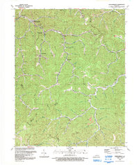
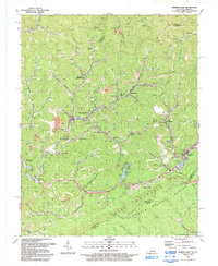
(13)- 1992 Map of Jenkins East
 1992 Jenkins East1992 Print · USGSThe Kentucky-Virginia borderlands in the early nineties show a landscape defined by mountain gaps and the extractive industry of the Cumberland Plateau. Genealogists can locate family landmarks like Haddon Cemetery and Mill Creek School alongside the numerous gas wells and strip mines that shaped the local economy.
 - 1992 Map of Dorton
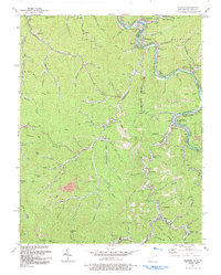
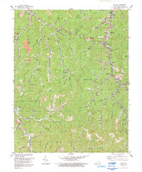
 1992 Dorton1992 Print · USGSPike County's coal-country hollows are captured here in the early nineties as mining and rail dominate the landscape. Trace local family history through the Newsome Memorial Cem and settlements like Virgie, Jonancy, and Dorton.
 - 1992 Map of Wheelwright
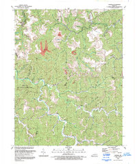
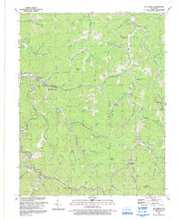
 1992 Wheelwright1992 Print · USGSEastern Kentucky's coal country comes into focus in the early nineties, revealing the deep-hollow settlements and industrial works of the Floyd and Pike county lines. Trace family roots and local history near Wheelwright, the Amy Little Cem, and the Mines of Weeksbury.
 - 1992 Map of Matewan
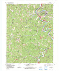
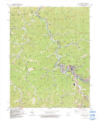
 1992 Matewan1992 Print · USGSThe Tug Fork border between West Virginia and Kentucky is shown here in the early nineties, revealing a dense landscape of coal hollows and river towns. Researchers can trace the heritage of Matewan and Blackberry City alongside landmarks like Blackberry Sch and the Delorme Post Office.
 - 1992 Map of Thomas
 1992 Thomas1992 Print · USGSThe rugged coal country of Eastern Kentucky is captured here during the early nineties, showing a landscape defined by hollows and heavy industry. Genealogists and local historians can locate rural landmarks such as Big Branch Ch, the settlement of McCombs, and the industrial infrastructure around Aldridge.
 - 1992 Map of Pikeville
 1992 Pikeville1992 Print · USGSPike County's coal country comes into sharp focus during the early nineties as the river and rail network supports a growing Pikeville. Genealogists and historians can trace family-named hollows and settlements like Kewanee, Little Dixie, and the Johnson Memorial Cem.
 - 1992 Map of Meta
 1992 Meta1992 Print · USGSPike County's coal country and narrow creek valleys come into focus in the early nineties, centered on the communities of Meta and Zebulon. Researchers can trace the legacy of resource extraction and local genealogy through numerous Mines, family-named hollows like Deskin Branch, and the Salem Ch.
 - 1992 Map of Jenkins West
 1992 Jenkins West1992 Print · USGSLetcher County coal country in the early nineties reveals a dense network of mountain settlements and headwaters. Trace family roots and local history through McRoberts, Hemphill, and churches like Moores Chapel or St George Ch.
 - 1992 Map of Broad Bottom
 1992 Broad Bottom1992 Print · USGSThe Levisa Fork valley shows its industrial character in the early nineties, with coal operations looming over a busy transport corridor. Trace family landmarks and rail stops from Blair Town and Coal Run to the Big Shoal Sta.
 - 1992 Map of Varney
 1992 Varney1992 Print · USGSEastern Kentucky's coal country and rural hollows are shown in the 1990s as mining and small mountain communities shaped the land. Researchers can trace family roots at Piso, Varney, and landmarks like Francis Cem or Apple Orchard Ch.
 - 1992 Map of Belfry
 1992 Belfry1992 Print · USGSPike County's coal country comes into focus in the early nineties as mining towns trace the path of Pond Creek. Researchers can locate family sites like Stump Cem or trace the industrial infrastructure of the Norfolk and Western RR and local mine dumps.
 - 1992 Map of Mc Dowell
 1992 Mc Dowell1992 Print · USGSThe coal country of Floyd County comes into focus in the early 1990s, showing the deep connection between the winding hollows and the regional mining economy. Researchers can trace local genealogy and industry through labels for Grethel PO, the Little Nancy Sch, and the CSX Transportation railroad.
 - 1992 Map of Williamson
 1992 Williamson1992 Print · USGSThe industrial heart of Mingo County is captured here in the early nineties, centered on the river-and-rail hub of Williamson. Genealogists and historians can trace the development of border towns like Nolan, Goodman, and Belfry along the Tug Fork.
End of results
Showing maps 1-13 of 13
Top cities of Pike County
Frequently asked questions
- What are the different types of historical maps available for Pike County?
- What is the oldest map of Pike County?
- Where can I purchase historical maps of Pike County for my home or office?
- Where can I download high-res historical maps of Pike County?
- Are there historical topographic maps available for Pike County?
- Is there historical aerial imagery available for Pike County?
- Where are historical maps of Pike County sourced from?