1900s (20th Century) Maps of Stanton, Kentucky
Explore 7 historic maps of Stanton from the 1900s (20th Century). These maps offer a rare glimpse into what life looked like during the 1900s — showing old roads, neighborhoods, homes, and landmarks that have changed or disappeared over time.
Whether you're researching your family's past, planning a metal detecting trip, or studying how Stanton's landscape evolved across the 1900s, these high-resolution maps are a powerful tool for exploring the history of this region.
- Focus on a specific era: All maps on this page are from the 1900s, giving you a focused view of this time period.
- See what’s changed: Compare century-old streets, trails, and buildings to today's modern landscape using overlays and satellite layers.
- Research with precision: Use these maps for genealogy, historical research, land use analysis, or educational projects.
- View, download, or print: Maps are fully viewable online in high resolution, and can be downloaded or printed for your own records.
Start exploring Stanton's history through authentic maps from the 1900s. This is your window into the past.
Stanton, KY maps
(7)- 1952 Map of Clay City, 1953 Print
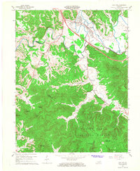
 1952 Clay City1953 Print · USGSThe Red River valley and the foothills of the Cumberland plateau are captured here in the early fifties. Genealogists can trace family names at Vaughns Mill, McKinney Cemetery, and rural landmarks like the Marbleyard School.
 - 1952 Map of Stanton, 1953 Print
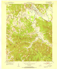
 1952 Stanton1953 Print · USGSPowell County's river valley and mountain ridges are captured in the early fifties as they were shaped by rural industry and timber. Genealogists can locate family landmarks like the Arthur Cem, Morris Creek Ch, and the school at Furnace.
 - 1957 Map of Jenkins, 1974 Print
 1957 Jenkins1974 Print · USGSThe Cumberland Plateau in the mid-twentieth century reveals a complex landscape of winding river valleys and deep-seated industry. Genealogists and historians can trace the development of Hazard, Jenkins, and Pikeville alongside extensive Numerous Oil and Gas Fields and the routes of the Chesapeake & Ohio Railway.
 - 1960 Map of Jenkins
 1960 Jenkins1960 Print · USGSEastern Kentucky and the West Virginia borderlands are captured at a mid-century peak of the coal and rail era. Trace the industrial corridors of the Chesapeake and Ohio RR through mountain hubs like Hazard and Jenkins.
 - 1966 Map of Stanton, 1968 Print
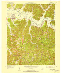
 1966 Stanton1968 Print · USGSThe Red River valley in the mid-sixties shows a landscape transitioning between its pioneer industrial past and modern infrastructure. Genealogists and historians can trace family-named landmarks like Rogers Chapel, the Estill Furnace Ruins, and small settlements such as Furnace or Rosslyn.3 unique versions available
 - 1966 Map of Clay City, 1968 Print
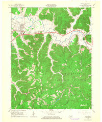
 1966 Clay City1968 Print · USGSClay City and the Red River valley are shown in the mid-sixties as the new Mountain Parkway began reshaping the local landscape. Researchers can trace rural lineages through sites like Vaughns Mill, the Cottage Furnace Ruins, and the Eaton Cem.2 unique versions available
 - 1982 Map of Irvine, 1983 Print
 1982 Irvine1983 Print · USGSEastern Kentucky's hill country is mapped here in the early eighties, showcasing the complex river valleys and ridge-top settlements of the Cumberland Plateau. Researchers can trace historic rail lines like the Louisville & Nashville RR or locate rural communities such as Beattyville and Slade.
End of results
Showing maps 1-7 of 7
Top cities near Stanton
- Mount Sterling historical maps
- Irvine historical maps
- Jeffersonville historical maps
- Clay City historical maps
- Camargo historical maps
- Ravenna historical maps
See more
Frequently asked questions
- What are the different types of historical maps available for Stanton?
- What is the oldest map of Stanton?
- Where can I purchase historical maps of Stanton for my home or office?
- Where can I download high-res historical maps of Stanton?
- Are there historical topographic maps available for Stanton?
- Is there historical aerial imagery available for Stanton?
- Where are historical maps of Stanton sourced from?