1970s Maps of Jamestown, Kentucky
Explore 2 historic maps of Jamestown from the 1970s. These maps offer a rare glimpse into what life looked like during the 1970s — showing old roads, neighborhoods, homes, and landmarks that have changed or disappeared over time.
Whether you're researching your family's past, planning a metal detecting trip, or studying how Jamestown's landscape evolved across the 1970s, these high-resolution maps are a powerful tool for exploring the history of this region.
- Focus on a specific era: All maps on this page are from the 1970s, giving you a focused view of this time period.
- See what’s changed: Compare century-old streets, trails, and buildings to today's modern landscape using overlays and satellite layers.
- Research with precision: Use these maps for genealogy, historical research, land use analysis, or educational projects.
- View, download, or print: Maps are fully viewable online in high resolution, and can be downloaded or printed for your own records.
Start exploring Jamestown's history through authentic maps from the 1970s. This is your window into the past.
Jamestown, KY maps
(2)- 1973 Map of Russell Springs, 1974 Print
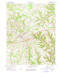 1973 Russell Springs1974 Print · USGSRussell County and the Adair County line are captured here in the early seventies as the region balanced its rural roots with new infrastructure. Genealogists can trace family landmarks like Mt Hope Ch, Hillcrest Cem, and the old settlements of Sano and Humble.
 - 1978 Map of Jamestown, 1979 Print
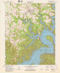 1978 Jamestown1979 Print · USGSLake Cumberland is shown in the late seventies as a mature recreational hub, with its winding shoreline defining the local topography. Trace family-owned landmarks and rural life near Sewellton and Freedom, or locate old sites like Lawless Cem and Concord Ch.
End of results
Showing maps 1-2 of 2
Top cities near Jamestown
Frequently asked questions
- What are the different types of historical maps available for Jamestown?
- What is the oldest map of Jamestown?
- Where can I purchase historical maps of Jamestown for my home or office?
- Where can I download high-res historical maps of Jamestown?
- Are there historical topographic maps available for Jamestown?
- Is there historical aerial imagery available for Jamestown?
- Where are historical maps of Jamestown sourced from?