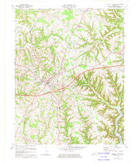
1900s (20th Century) Maps of Jamestown, Kentucky
Explore 10 historic maps of Jamestown from the 1900s (20th Century). These maps offer a rare glimpse into what life looked like during the 1900s — showing old roads, neighborhoods, homes, and landmarks that have changed or disappeared over time.
Whether you're researching your family's past, planning a metal detecting trip, or studying how Jamestown's landscape evolved across the 1900s, these high-resolution maps are a powerful tool for exploring the history of this region.
- Focus on a specific era: All maps on this page are from the 1900s, giving you a focused view of this time period.
- See what’s changed: Compare century-old streets, trails, and buildings to today's modern landscape using overlays and satellite layers.
- Research with precision: Use these maps for genealogy, historical research, land use analysis, or educational projects.
- View, download, or print: Maps are fully viewable online in high resolution, and can be downloaded or printed for your own records.
Start exploring Jamestown's history through authentic maps from the 1900s. This is your window into the past.
Jamestown, KY maps
(10)- 1953 Map of Jamestown, 1955 Print
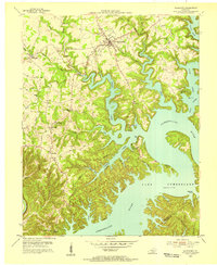 1953 Jamestown1955 Print · USGSThe Russell County uplands meet the newly formed reservoir in the early fifties, showing a landscape reshaped by the water. Trace family roots in Freedom, Sewellton, and Rowena, or locate remote landmarks like Worldridge Sch and Belle Chapel.2 unique versions available
 - 1954 Map of Russell Springs, 1955 Print
 1954 Russell Springs1955 Print · USGSThe Russell Springs area in the mid-fifties shows a rural landscape adapting to the new shoreline of Lake Cumberland. Local researchers can trace family roots through numerous landmarks like Webbs Cross Roads, Central High Sch, and Beckham Ridge Ch.2 unique versions available
 - 1956 Map of Corbin, 1966 Print
 1956 Corbin1966 Print · USGSThe Kentucky and Tennessee borderlands are captured here in the mid-fifties, showing the region's shift toward modern interstate travel and reservoir development. Genealogists and historians can trace old community lines near Albany and Monticello or locate early rail junctions along the Southern and Tennessee Central lines.3 unique versions available
 - 1957 Map of Winchester, 1968 Print
 1957 Winchester1968 Print · USGSCentral Kentucky's landscape in the mid-twentieth century features the sprawling Fort Knox and the early parkway system. Genealogists and historians can trace rail lines like the Southern Railway and find landmarks from Bernheim Forest to Pilot Knob.3 unique versions available
 - 1958 Map of Corbin
 1958 Corbin1958 Print · USGSThe Upper Cumberland borderlands appear in the late 1950s as massive reservoirs and early atomic-era growth reshape the region. Trace family roots and vanished landmarks near Lake Cumberland, Oak Ridge, and the Cumberland National Forest.
 - 1960 Map of Winchester
 1960 Winchester1960 Print · USGSCentral Kentucky's diverse landscape is shown here at mid-century, from the bluegrass plains to the rugged Pottsville Escarpment. Genealogists and historians can trace the rail-and-river network connecting towns like Bardstown and Stanford alongside landmarks like Lake Cumberland.
 - 1973 Map of Russell Springs, 1974 Print
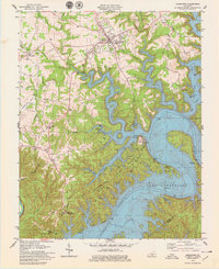
 1973 Russell Springs1974 Print · USGSRussell County and the Adair County line are captured here in the early seventies as the region balanced its rural roots with new infrastructure. Genealogists can trace family landmarks like Mt Hope Ch, Hillcrest Cem, and the old settlements of Sano and Humble.
 - 1978 Map of Jamestown, 1979 Print
 1978 Jamestown1979 Print · USGSLake Cumberland is shown in the late seventies as a mature recreational hub, with its winding shoreline defining the local topography. Trace family-owned landmarks and rural life near Sewellton and Freedom, or locate old sites like Lawless Cem and Concord Ch.
 - 1985 Map of Tompkinsville, 1986 Print
 1985 Tompkinsville1986 Print · USGSThe Kentucky-Tennessee borderlands come into focus in the mid-1980s, showcasing a landscape of river-fed valleys and rural crossroads. Genealogists and local historians can trace family locations from Glasgow and Edmonton to the distinctively named Eighty Eight, Bugtussle, and Akersville.2 unique versions available
 - 1986 Map of Campbellsville
 1986 Campbellsville1986 Print · USGSCentral Kentucky in the mid-eighties was a landscape of deep river valleys and high ridges. Genealogists can trace family holdings near rural settlements like Phillipsburg or locate landmarks such as Mt Gilead Ch and the Magnolia Gas Storage Field.2 unique versions available
End of results
Showing maps 1-10 of 10
Top cities near Jamestown
Frequently asked questions
- What are the different types of historical maps available for Jamestown?
- What is the oldest map of Jamestown?
- Where can I purchase historical maps of Jamestown for my home or office?
- Where can I download high-res historical maps of Jamestown?
- Are there historical topographic maps available for Jamestown?
- Is there historical aerial imagery available for Jamestown?
- Where are historical maps of Jamestown sourced from?